
Nuaillé-sur-Boutonne
| Nuaillé-sur-Boutonne | ||
|---|---|---|
|
||
| region | Nouvelle-Aquitaine | |
| Department | Charente-Maritime | |
| Arrondissement | Saint-Jean-d'Angély | |
| Canton | Matha | |
| Community association | Vals de Saintonge | |
| Coordinates | 46 ° 1 ′ N , 0 ° 26 ′ W | |
| height | 21-69 m | |
| surface | 10.48 km 2 | |
| Residents | 198 (January 1, 2017) | |
| Population density | 19 inhabitants / km 2 | |
| Post Code | 17470 | |
| INSEE code | 17268 | |
 Town hall (Mairie) of Nuaillé-sur-Boutonne |
||

Nuaillé-sur-Boutonne is a French municipality with 198 inhabitants (as of January 1 2017) in the Charente-Maritime in the region Nouvelle-Aquitaine (before 2016: Poitou-Charentes ); it belongs to the arrondissement Saint-Jean-d'Angély and is part of the canton Matha (until 2015: canton Aulnay ). The inhabitants are called Nuailléens .
geography
Nuaillé-sur-Boutonne is located about 60 kilometers east-southeast of La Rochelle in the Saintonge . Nuaillé-sur-Boutonne is surrounded by the neighboring communities of Saint-Georges-de-Longuepierre in the north, Aulnay in the east, Paillé in the south and southeast, Les Églises-d'Argenteuil in the south, Saint-Pardoult in the southwest and Saint-Pierre-de -l'Isle to the west and northwest.
Population development
| year | 1962 | 1968 | 1975 | 1982 | 1990 | 1999 | 2006 | 2013 |
| Residents | 274 | 244 | 233 | 202 | 196 | 178 | 190 | 209 |
| Source: Cassini and INSEE | ||||||||
Attractions
See also: List of Monuments historiques in Nuaillé-sur-Boutonne
- Notre-Dame church from the 12th century, monument historique since 1984
- Notre-Dame priory of Oulmes, mentioned in 1326
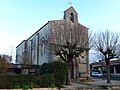
Notre-Dame church

Notre-Dame priory of Oulmes


literature
- Le Patrimoine des Communes de la Charente-Maritime. Flohic Editions, Volume 1, Paris 2002, ISBN 2-84234-129-5 , pp. 130-131.