
Les Nouillers
| Les Nouillers | ||
|---|---|---|
|
||
| region | Nouvelle-Aquitaine | |
| Department | Charente-Maritime | |
| Arrondissement | Saint-Jean-d'Angély | |
| Canton | Saint-Jean-d'Angély | |
| Community association | Vals de Saintonge | |
| Coordinates | 45 ° 56 ′ N , 0 ° 40 ′ W | |
| height | 2-64 m | |
| surface | 24.15 km 2 | |
| Residents | 698 (January 1, 2017) | |
| Population density | 29 inhabitants / km 2 | |
| Post Code | 17380 | |
| INSEE code | 17266 | |
 Town hall (Mairie) of Les Nouillers |
||

Les Nouillers is a French municipality with 698 inhabitants (as of January 1 2017) in the Charente-Maritime in the region Nouvelle-Aquitaine (before 2016: Poitou-Charentes ); it belongs to the arrondissement of Saint-Jean-d'Angély and the canton of Saint-Jean-d'Angély (until 2015: canton of Saint-Savinien ). The inhabitants are called Novelariens .
geography
Les Nouillers is about 45 kilometers southeast of La Rochelle . Les Nouillers is surrounded by the neighboring communities of Torxé in the north, Voissay in the east and northeast, Bignay in the east and southeast, Taillant in the southeast, Saint-Savinien in the south, Archingeay in the west and Tonnay-Boutonne in the northwest.
Population development
| year | 1962 | 1968 | 1975 | 1982 | 1990 | 1999 | 2006 | 2013 |
| Residents | 642 | 593 | 534 | 618 | 607 | 611 | 623 | 655 |
| Source: Cassini and INSEE | ||||||||
Attractions
See also: List of Monuments historiques in Les Nouillers
- Saint-Pierre church from the 12th century, monument historique
- Bois-Charmant Castle from the 16th century
- Former windmill
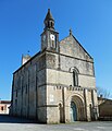
Saint-Pierre church

Bois-Charmant Castle

Former windmill


literature
- Le Patrimoine des Communes de la Charente-Maritime. Flohic Editions, Volume 2, Paris 2002, ISBN 2-84234-129-5 , pp. 966-967.