
Archingeay
| Archingeay | ||
|---|---|---|
|
||
| region | Nouvelle-Aquitaine | |
| Department | Charente-Maritime | |
| Arrondissement | Saint-Jean-d'Angély | |
| Canton | Saint-Jean-d'Angély | |
| Community association | Vals de Saintonge | |
| Coordinates | 45 ° 56 ′ N , 0 ° 42 ′ W | |
| height | 2-47 m | |
| surface | 16.61 km 2 | |
| Residents | 671 (January 1, 2017) | |
| Population density | 40 inhabitants / km 2 | |
| Post Code | 17380 | |
| INSEE code | 17017 | |
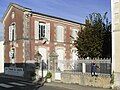
 Archingeay Town Hall (Mairie) |
||

Archingeay is a French municipality with 671 inhabitants (as of January 1 2017) in the Charente-Maritime in the region Nouvelle-Aquitaine (before 2016: Poitou-Charentes ); it belongs to the arrondissement of Saint-Jean-d'Angély and is part of the canton of Saint-Jean-d'Angély (until 2015: canton of Saint-Savinien ). The inhabitants are called Arcantois .
geography
Archingeay is located about 55 kilometers southeast of La Rochelle in the Saintonge . Archingeay is surrounded by the neighboring communities of Tonnay-Boutonne in the north, Les Nouillers in the east, Saint-Savinien in the south, Champdolent in the southwest and Puy-du-Lac in the west and northwest.
Population development
| year | 1962 | 1968 | 1975 | 1982 | 1990 | 1999 | 2006 | 2013 |
| Residents | 603 | 536 | 504 | 527 | 539 | 519 | 597 | 694 |
| Source: Cassini and INSEE | ||||||||
Attractions
See also: List of Monuments historiques in Archingeay
- Saint-Martin church from the 12th century
- Museum Treasures of Lisette (Tresors de Lisette) with exhibits from the Belle Epoque

Saint Martin Church
Museum Tresors de Lisette


literature
- Le Patrimoine des Communes de la Charente-Maritime. Flohic Editions, Volume 2, Paris 2002, ISBN 2-84234-129-5 , pp. 958-959.