
Mazeray
| Mazeray | ||
|---|---|---|
|
||
| region | Nouvelle-Aquitaine | |
| Department | Charente-Maritime | |
| Arrondissement | Saint-Jean-d'Angély | |
| Canton | Saint-Jean-d'Angély | |
| Community association | Vals de Saintonge | |
| Coordinates | 45 ° 54 ′ N , 0 ° 34 ′ W | |
| height | 15-101 m | |
| surface | 19.38 km 2 | |
| Residents | 959 (January 1, 2017) | |
| Population density | 49 inhabitants / km 2 | |
| Post Code | 17400 | |
| INSEE code | 17226 | |
_mairie,_monument_aux_morts,_salle_polyvalente.JPG) Mazeray Town Hall (Mairie) |
||

Mazeray is a French municipality with 959 inhabitants (as of January 1 2017) in the Charente-Maritime in the region Nouvelle-Aquitaine (before 2016: Poitou-Charentes ); it belongs to the arrondissement of Saint-Jean-d'Angély and is part of the canton of Saint-Jean-d'Angély . The inhabitants are called Macériens .
geography
Mazeray is located about 42 kilometers east-southeast of La Rochelle in the Saintonge . Mazeray is surrounded by the neighboring communities of Ternant in the north, Saint-Jean-d'Angély in the east and northeast, Asnières-la-Giraud in the east, Saint-Hilaire-de-Villefranche in the south, Fenioux in the southwest and Bignay in the west.
The A10 autoroute runs through the municipality .
In the municipality is the Circuit du Puy de Poursay , a motocross track on which the world championship title was determined in the past.
Population development
| year | 1962 | 1968 | 1975 | 1982 | 1990 | 1999 | 2006 | 2017 |
| Residents | 589 | 558 | 580 | 707 | 762 | 779 | 881 | 959 |
| Sources: Cassini and INSEE | ||||||||
Attractions
- Nativité-de-la-Vierge church from the 12th century, alterations from the 14th century
- Beaufief Castle from the 16th century, renovations up to the 18th century, since 1973 Monument historique
See also: List of Monuments historiques in Mazeray

Nativité-de-la-Vierge church
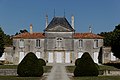
Beaufief Castle
_%C3%A9glise_de_la_Nativit%C3%A9_de_la_Sainte-Vierge_PA00104800.JPG)

literature
- Le Patrimoine des Communes de la Charente-Maritime. Flohic Editions, Volume 2, Paris 2002, ISBN 2-84234-129-5 , pp. 876-877.