
Annepont
| Annepont | ||
|---|---|---|
|
||
| region | Nouvelle-Aquitaine | |
| Department | Charente-Maritime | |
| Arrondissement | Saint-Jean-d'Angély | |
| Canton | Saint-Jean-d'Angély | |
| Community association | Vals de Saintonge | |
| Coordinates | 45 ° 55 ′ N , 0 ° 48 ′ W | |
| height | 1-35 m | |
| surface | 8.81 km 2 | |
| Residents | 377 (January 1, 2017) | |
| Population density | 43 inhabitants / km 2 | |
| Post Code | 17350 | |
| INSEE code | 17011 | |
 Annepont Town Hall (Mairie) |
||

Annepont is a French municipality with 377 inhabitants (as of January 1 2017) in the Charente-Maritime in the region Nouvelle-Aquitaine (before 2016: Poitou-Charentes ); it belongs to the arrondissement of Saint-Jean-d'Angély and the canton of Saint-Jean-d'Angély (until 2015: canton of Saint-Savinien ). The inhabitants are called Annepontois .
geography
Annepont is about 50 kilometers southeast of La Rochelle . Annepont is surrounded by the neighboring communities of Taillebourg in the north, south and west, La Frédière in the north-east and Juicq in the east.
Population development
| year | 1962 | 1968 | 1975 | 1982 | 1990 | 1999 | 2006 | 2017 |
| Residents | 216 | 184 | 177 | 220 | 208 | 267 | 276 | 377 |
| Sources: Cassini and INSEE | ||||||||
Attractions
- Saint-André church from the 12th century, monument historique since 1907
- House Maine-Moreau, Monument historique since 1949
- Watermill
See also: List of Monuments historiques in Annepont
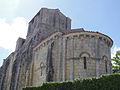
Saint-André church

Maine-Moreau house
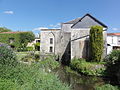
Watermill
_%C3%89glise_Saint-Andr%C3%A9_PA00104592_chevet.JPG)

_moulin_%C3%A0_eau.JPG)
literature
- Le Patrimoine des Communes de la Charente-Maritime. Flohic Editions, Volume 2, Paris 2002, ISBN 2-84234-129-5 , p. 957.
Web links
Commons : Annepont - collection of images, videos and audio files