Algiers
|
مدينة الجزائر Madinat al-Jaza'ir دزاير Dzayer ⴷⵣⴰⵢⴻⵔ ⵜⴰⵎⴰⵏⴻⵖⵜ Dzayer tamaneɣt Algiers |
||
|---|---|---|
|
|
||
| Coordinates | 36 ° 46 ' N , 3 ° 3' E | |
| Symbols | ||
|
||
| Basic data | ||
| Country | Algeria | |
| Algiers | ||
| ISO 3166-2 | DZ-16 | |
| height | 10 m | |
| surface | 273 km² | |
| Metropolitan area | 865 km² | |
| resident | 2,159,051 | |
| Metropolitan area | 3,456,701 (January 1, 2008) | |
| density | 7,908.6 Ew. / km² | |
| Metropolitan area | 3,996.2 Ew. / km² | |
| Postal code | (CEP) 16000-16132 | |
| politics | ||
| Wali | Youcef Cherfa | |
| Others | ||
|
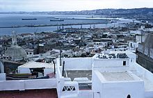
View of Algiers (2005)
|
||
Algiers ([ ˈalʒiːɐ̯ ]; Arabic مدينة الجزائر Madīnat al-Jazā'ir , Algerian Arabic دزاير Dzayer , Berber ⴷⵣⴰⵢⴻⵔ ⵜⴰⵎⴰⵏⴻⵖⵜ Dzayer tamaneɣt [ dzæˈjer ], French Alger ) is the capital of Algeria . The largest city in the country and its namesake is an industrial city, transport hub and cultural center with universities, numerous institutes, galleries and museums. Located on the west side of a bay of the Mediterranean, the city is nicknamed Alger la blanche because of the glittering white buildings rising from the sea.
2.2 million people live in the urban settlement area of the core city (high density of buildings and closed locality). The province of Algiers with a total of 57 municipalities has 3.5 million inhabitants (2008). In the last few decades a larger suburban belt has formed around the city. 6.3 million people (2008) live in the metropolitan region , which extends far beyond the borders of the province. In addition to the province, Algiers is actually only called the municipality (around 150,000 inhabitants) that encompasses the city center.
The image of the older quarters of Algiers is shaped by the Kasbah with the Kechava Mosque built in 1612 , a castle from the 16th century, the Great Mosque from the 11th century and buildings from the French colonial period (1830–1962). In 1992 the old town (also called the Kasbah ) was declared a World Heritage Site by UNESCO .
etymology
The name goes back to the Arabic al-Jazā'ir ("the islands") and refers to four islands on which the city was founded. These became part of the mainland in the 16th century.
geography
Geographical location
Algiers is located in the province of the same name in the western part of a bay of the Mediterranean Sea , on the mountain slopes of the Algerian Sahel (Sahel algérois), a foothill of the Atlas Mountains .
The steeply rising Tell Atlas with the Algerian capital rises behind the narrow, bay-rich edge of the Mediterranean coast . The mountain range, divided by basins, longitudinal and transverse valleys, reaches an altitude of 2,308 meters east of Algiers in the wild gorges of Kabylia . On its south side, the Tell Atlas falls to the Schotts highlands (391 meters to well over 1,000 meters above sea level), which has numerous drainless, marshy salt lakes, the so-called Schotts , inside .
The mostly short continuous rivers in the coastal region can turn into torrential rivers due to heavy rains. In the vicinity of Algiers, on the sufficiently irrigated north side of the Tell Atlas , grow Mediterranean shrubs such as maquis , Aleppo pines , cork oaks and holm oaks and (over 1,600 meters) Atlas cedars ; There are still contiguous forest areas in Kabylia.
The province has an area of 865 square kilometers. Of this, 273 square kilometers (32 percent) belong to the core city (high density of buildings and closed locality), 592 square kilometers (68 percent) consist of suburbs and areas with a rural settlement structure. The urban settlement area has an extension of about 30 kilometers.
geology
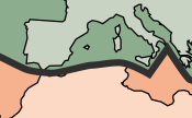
The Algerian capital, Algiers, is located in an earthquake-prone zone. In terms of plate tectonics , the Atlas Mountains form the boundary between the Eurasian Plate in the north and the African Plate in the south. If these two plates rub against each other, earthquakes can occur. The records of strong earthquakes in the region around the capital Algiers go back to the 14th century.
Severe earthquakes struck Algiers on January 2, 1365 and March 10, 1673. In an earthquake on February 3, 1716, around 20,000 people died in the region around Algiers. An earthquake in the city of Blida , southwest of the capital, claimed around 7,000 lives on March 2, 1825. The city was completely destroyed. Only a few decades later, on January 2nd, 1867, Blida was destroyed again by an earthquake.
In the city of Ech Cheliff , west of the Algerian capital, around 5,000 people died in an earthquake with a magnitude of 7.3 on the Richter scale on October 10, 1980. A 6.8 magnitude earthquake on May 21, 2003 in the city of Zemmouri east of Algiers claimed around 2,000 lives.
City structure
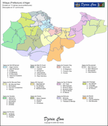
The province of Algiers (of which the core city of Algiers takes about a third) is divided into 13 districts (Daïras) and 57 municipalities (Communes), one of which is the municipality of Alger-Center (about 150,000 inhabitants).
- Daïra from Bab El Oued: Bab El-Oued, Casbah, Bologhine, Hammamet, Oued Koriche, Rais Hamidou
- Daïra of Baraki: Baraki, Les Eucalyptus, Sidi Moussa
- Daïra by Bir Mourad: Raïs, Bir Mourad Raïs, Birkhadem, Gué de Constantine, Saoula
- Daïra from Birtouta: Birtouta, Ouled Chebel, Tessala El Merdja
- Daïra from Bouzareah: Ben Aknoun, Beni Messous, Bouzareah, Dely Brahim
- Daïra of Chéraga: Aïn Benian, Chéraga, Ouled Fayet, El Achour
- Daïra from Dar El Beïda: Aïn Taya, Bab Ezzouar, Bordj El Bahri, Bordj El Kiffan, Dar El Beïda, El Marsa
- Daïra of Draria: Baba Hassen, Douera, Draria, Khraïssia
- Daïra von El Harrach: Bachdjerrah, El Harrach, Oued Smar, Mohammadia
- Daïra by Hussein Dey: Bourouba, El Magharia, Hussein Dey, Kouba
- Daïra of Rouïba: H'raoua, Reghaïa, Rouïba
- Daïra by Sidi M'Hamed: Algiers Center, Sidi M'Hamed, El Biar, El Madania, El Mouradia, Hamma-Anassers, Hydra
- Daïra of Zeralda: Mahelma, Rahmania, Souidania, Staouali, Zeralda
climate
Algiers is located in the Mediterranean climate zone with warm and dry summers and cool and rainy winters. The annual average temperature is 18.2 ° Celsius. The warmest month is August with an average of 25.2 ° Celsius, the coldest months January and February with an average of 12.2 to 12.6 ° Celsius. Sea breezes cool off on hot days. In winter there are frequent storms with heavy rains.
On November 9, 2001, 672 people died in heavy storms in Algiers and 1,500 families were made homeless. Heavy rains had triggered mud and debris avalanches that tore away lightly built houses in the poor neighborhoods on the hills of the Algerian capital. With 120 millimeters of rain within one day, more precipitation fell than in the rest of the month.
The average annual rainfall is 598 mm. Most of the precipitation falls between November and February with an average of 72.7 to 91.0 mm, the least between June and August with an average of 4.5 to 8.5 mm.
| Algiers | ||||||||||||||||||||||||||||||||||||||||||||||||
|---|---|---|---|---|---|---|---|---|---|---|---|---|---|---|---|---|---|---|---|---|---|---|---|---|---|---|---|---|---|---|---|---|---|---|---|---|---|---|---|---|---|---|---|---|---|---|---|---|
| Climate diagram | ||||||||||||||||||||||||||||||||||||||||||||||||
| ||||||||||||||||||||||||||||||||||||||||||||||||
|
Average monthly temperatures and rainfall for Algiers
Source: wetterkontor.de
|
|||||||||||||||||||||||||||||||||||||||||||||||||||||||||||||||||||||||||||||||||||||||||||||||||||||||||||||||||||||||||||||||||||||||||||||||||||||||||||||||||||||||||||||||||||||||||||||||||||
story
City foundation
Around 1200 BC The Phoenicians settled the area of today's city. They founded a trading post on the Bay of Algiers and named it Icosim . After the Punic Wars ended , the settlement came in 146 BC. Under the supremacy of the kings of Mauritania. As Icosium , it belonged to the Roman province of Mauretania Caesariensis since 42 AD and was a base of the Mauritanian fleet (Classis Mauretanica) .
In 429 the Vandals under King Geiseric conquered the place. From 533 the city was part of the Byzantine Empire until it was destroyed by Arab forces in 681. In 950 Buluggin ibn Ziri , ruler of the Berber dynasty of the Zirids , founded another settlement on the coast. Over the next five centuries, the place was taken several times by European, Arab and Berber troops, but did not achieve great supra-regional importance.
Barbarian state
In the 16th century, after the reconquest of Granada in 1492 by the Spanish Queen Isabella I of Castile and King Ferdinand II. Of Aragon made Muslim pirates ( corsairs ), many of whom had fled from Spain Moors were, Algiers, Tunis , Tripoli and Morocco to their base. From here they waged an asymmetrical guerrilla war against the merchant shipping of the Christian Mediterranean powers. You acted here from a bundle of motives. These were political, Islamic, religious and material in nature. These areas, known as barbarian states (barbarians = barbarians or Berbers ), waged a bitter struggle against the Christian Mediterranean powers, especially their shipping and coasts, and enslaved their victims. At that time, up to 40% of the population of Algiers were enslaved Europeans.
The most famous corsair leader was Khair ad-Din Barbarossa . After conquering Algiers, he submitted himself and his territory to the Ottoman Sultan in 1518 , who in this way became overlord of North Africa (with the exception of Morocco) and won a powerful fleet. Algiers was formally a province of the Ottoman Empire and the seat of the Deys , the sultan's governor, but became de facto independent from the middle of the 17th century. Most of the city's population lived from piracy .
The state of war with the Western States were piracy formal legitimization of the usual war privateering . The attempts of the European powers to conquer the city and to put a stop to piracy failed. In 1541 Charles V , Holy Roman Emperor and King of Spain , sent his troops against Algiers. He failed just like the Danes in 1770 and Spain with his army in 1775.
In 1805, Jérôme Bonaparte succeeded on behalf of his brother Napoleon in ransoming a large number of Italian prisoners. The propaganda motivated action was rather counterproductive in the struggle of the European Mediterranean neighbors against piracy (and ultimately revealed once more France's weakness in naval warfare).

Even a British squadron of 19 warships under the command of Edward Pellew , supported by 11 Dutch frigates under the command of Theodorus Frederik van Capellen , failed to conquer the city on August 27, 1816. However, by destroying his fleet and bombing his capital and its fortifications the next day, the armed forces forced the Dey Omar of Algiers to a treaty that led to the release of the Christian slaves and the repayment of ransom money already paid.
With the strengthening of the Christian seafaring powers, especially Great Britain, France and the Netherlands, piracy against Christian trade in the Mediterranean increasingly lost its importance. Commercial trade with Europe, especially France, increased in the 18th and 19th centuries. The piracy of the corsairs came to an end with the battle of Navarino on October 20, 1827, when the warships of the barbarians allied with the Ottoman Empire were destroyed.
One of the largest employers in Algiers before the French conquest were the mosques. Four to seven percent of the urban male population worked in mosques.
French conquest and domination
On April 29, 1827, the Dey of Algiers, Hussain III. , the French consul Pierre Deval at an audience several times with the fly whisk after the consul had refused Deys' request with an insulting remark to repay the loan he had granted to Napoleon Bonaparte during the Italian campaign in 1796 .
For the Bourbons ruling France , this was an attack on the honor of their country. And so the French King Charles X used this incident as an excuse to declare war on the Dey. On June 16, 1827, a three-year blockade of the port of Algiers began.
This step was primarily due to the domestic political situation in France, which forced the king to draw public attention to the real danger posed by the North African corsairs.
The decisive military strike against Algiers did not take place until 1830, when King Charles X was politically at an end. The conquest of Algiers on July 5, 1830 could no longer stop the July Revolution in France, but in the following decades this military success was described as a measure in the fight against the Islamic threat to the Christian neighbors of the Mediterranean. The population of Algiers decreased by around 30,000 people due to killing or displacement.
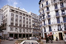
In 1830, Algiers became the capital of the French colony and, in 1848, with the February Revolution, it also became the capital of the department of Algiers. In the second half of the 19th century, many Europeans, mainly French, but also of Italian, Spanish and Maltese origins, came to the city. These moved mainly to the suburbs, while the local population concentrated more in the kasbah. Several residential areas for Europeans were built, which still shape the image of the city today, including the two-kilometer-long boulevard in the harbor district.
The anti-Semitic riots in France spread to Algeria's French in the course of the Dreyfus affair . In 1898, the naturalized Italian Max Régis , born in Sétif , editor-in-chief of the magazine L'Antijuif , who served anti-Semitism among the Algerian French with a monothematic program, was elected mayor with an overwhelming majority. In the elections in May 1898, four anti-Semitic MPs for Algeria also entered the French Chamber of Deputies . With Edouard Drumont , who won 11,557 votes, and Charles Marchal , Algiers sent two anti-Semitic MPs to Paris. After provocations against public order, however, Régis was removed from office a little later. However, Régis managed to get some anti-Semitically motivated personnel decisions through in two meetings of the city council.
With the development of the local economy, the population increased rapidly. In 1896 130,726 people lived in the city, of whom 63,755 were French and 24,970 were other Europeans. In addition, 30,777 Muslims and 11,224 Jews lived in Algiers. After the First World War (1914–1918), the Muslim population grew considerably through natural growth and rural exodus.
Second World War
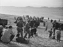
During the Second World War, Algeria belonged to France not occupied by Germany under the collaboration regime of Henri Philippe Pétain . On November 7, 1942, US and British soldiers landed together with French resistance fighters as part of Operation Torch in Algiers and other cities in North Africa.
As early as the early morning hours of November 8th, 400 resistance fighters , supported by a US Vice Consul, arrested the majority of the Vichy military and civil authorities in Algiers and took key positions including the switchboard, the radio station, the governor's palace, the prefecture, the headquarters of the staff, the headquarters of the 19th Corps of Vichy French troops and the coastal artillery of Sidi Ferruch.
Admiral François Darlan , commander-in-chief of the Vichy troops, and other officers were captured by young French patriots of the Resistance during the "coup of November 8, 1942", but were then freed again by the Guard Mobile. The poorly equipped Resistance fighters withstood the attacks of the Vichy troops for 15 hours, which made it possible for the Allies to encircle the city.
The US and British soldiers occupied Algiers that evening without much resistance and accepted Darlan's surrender. Fighting only took place in the port of Algiers, where two British destroyers tried to drop some US soldiers directly on the dock to prevent the Vichy government soldiers from destroying port facilities and sinking ships. Algiers was the capital of Free France until the liberation of Paris .
Algerian war
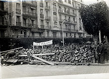
Between January and October 1957, during the Algerian War, the Battle of Algiers took place , a military conflict in which the French army and the Algerian nationalist rebel organization FLN faced each other in Algiers. It was part of the Algerian War and was an important element of the French pacification strategy in relation to Algeria.
There were attacks, kidnappings and murders by the FLN group around Yacef Saâdi , but also mass arrests with enforced disappearances , systematic torture and deportations by the French paratroopers ("Paras") under Jacques Massu of the Foreign Legion and by lynching troops from the Pied noir . Although the Battle of Algiers in January to September 1957 was tantamount to a military defeat for the FLN, the Algerian rebel organization also achieved a political victory. The systematic use of torture had discredited France internationally and was perceived as scandalous by large parts of the French public. In 1962 Algeria became independent and Algiers became the seat of the country's government. In the spring of 1962 there was still fierce fighting between the French army and the French nationalist terrorist group Organization de l'Armée Secrète (OAS) . After Algeria's independence, the OAS blew up the Algiers library. After independence, the 1.4 million pied noirs, who made up 13% of the total population, left the country.
independence
In October 1988 serious unrest broke out in Algiers and other cities in the country, which led to the abandonment of the FLN's monopoly of power. The causes were, among other things, high unemployment and the housing shortage. A democratization was launched and a new democratic constitution , the separation of party and state, parliamentary accountability, pluralism , political freedoms and guarantees of human rights envisaged created.
The economic decline around 1990 led to the rise of the Islamist movement. After the emerging victory of the Islamic Salvation Front (Front islamique du salut / FIS) in the parliamentary elections in 1991/1992, the elections were canceled. In March 1992 the order to dissolve the FIS followed, which then called for armed struggle.
The civil war between militant Islamists and the Algerian government has killed tens of thousands of people in Algiers and across the country. On August 26, 1992, an attack by guerrillas who detonated a bomb in Algiers airport left nine people dead and 128 injured. Young people in particular were disappointed that the FIS had abandoned the liberalization it sought . Their hopelessness resulted in their relapse into Islamist radicalization ; their only remaining and therefore proven hold.
On September 30, 2005, Algerian voters, including most of the residents of Algiers, voted for national reconciliation. In a referendum on the “Charte pour la paix et la réconciliation nationale”, 97 percent of voters approved the Abdelaziz Bouteflika government's plan . This means an amnesty for many Islamist extremists. But attacks continue even after the vote.
On April 11, 2007, 33 people died in two bomb attacks in Algiers. One explosion occurred near the official residence of the Algerian Prime Minister Abdelaziz Belkhadem , and another bomb exploded outside a police station in the suburb of Bab Ezzouar. The organization "al-Qaida of the Islamic Maghreb", which emerged on January 25, 2007 from the radical Islamist group Salafist Group for Preaching and Struggle (GSPC), took responsibility for the attacks.
According to the Algerian Interior Minister Yazid Zerhouni, at least 26 people were killed in bomb attacks on December 11, 2007 on the building of the refugee aid organization UNHCR in the Hydra district and near the Supreme Court in the neighboring Ben Akoun district. The “al-Qaida of the Islamic Maghreb” also claimed responsibility for these attacks.
In 2011, large sections of the population protested in Algiers. The unrest in Algeria 2010–2012 was directed primarily against the rise in basic food prices .
Population development

The city's population grew from around 30,000 in 1838 to around 97,000 in 1899 in the 19th century. Growth accelerated in the 20th century. In 1906 around 138,000 people were still living in Algiers, by 2008 it was 2.2 million. The province of Algiers has 3.5 million inhabitants, the metropolitan region 6.3 million (2008).
Mainly Arabs and various Berber tribes , some of which are Arabized, live in the capital . However, it must be noted that these ethnic groups have merged more and more in the last few decades, so that it is now difficult to assign an Algerian to a certain tribe, because more and more have Arab and Berber roots. The number of Europeans fell to a few thousand after independence.
The high rate of emigration is mainly due to a lack of job opportunities and growing population pressure; numerous capitals live abroad, many of them in France. Around 34 percent of the population was under 15 years old in 2003, life expectancy in 2003 was 71 years.
The following overview shows the development of the population of the core city (excluding the suburbs).
|
|
politics
City government
The province of Algiers is divided into counties and municipalities. It is ruled by a governor ( Wālī ) who is appointed by the country's president and reports to the Ministry of the Interior. Since 1996 the Wali of Algiers has held the rank of minister. It is supported by an executive council.
Each of the municipalities, including Algiers, is governed by a municipal people's assembly (Assemblée Populaire Communale, APC), which is elected for four years. She is responsible for the local administration as well as the areas of economy, finance and culture. The people's assembly elects a local executive council and its president. All councilors, including the president, report to the Ministry of the Interior.
Town twinning
Algiers has partnerships with the following cities.
Culture and sights
language
The official language is Arabic . In addition, French plays an important role as an educational, commercial and lingua franca. State television stations broadcast news and documentaries in French in Algiers. The written language is either French or Standard Arabic , although there is a government initiative to use Standard Arabic. Most of the population in the Algerian capital speaks Arabic as their mother tongue.
Religions
The state religion in Algeria is Sunni Islam . According to official statistics, around 99% of the population are followers of this religion. Only a small minority, mostly foreigners living in the city, but also a few Algerians, are shaped by Christianity or Judaism . However, this tiny minority lives their faith very discreetly.
The region's Roman Catholic Church is headed by the Archbishop of Algiers . The diocese was established as a diocese on August 10, 1838 and raised to an archbishopric on July 25, 1866 . Suffragan dioceses are the Diocese of Constantine and the Diocese of Oran .
The 54,927 square kilometer archdiocese had around 50,000 believers in 1970 and 35,000 in 1980. Today there are only 1,500 Catholics left, with a population of nine million people in this region. The departure of the French occupation led to a profound restructuring in the archdiocese, as in the other dioceses of Algeria.
In the wake of the civil war that broke out in 1992 between the government and the Islamist Salvation Front (FIS), which did not shy away from mass murders among its own people, many people turned to Christianity. A law that came into force on March 28, 2006 places proselytizing under heavy penalties.
Museums
In the modern part of the city there is an opera and many museums. The Musée Le Bardo houses ethnographic collections of fossils, tools and weapons from the Paleolithic and Neolithic, as well as costumes and jewelry from all over the country. The National Museum of Fine Arts has an exhibition of modern French and Algerian painting, including works by Bachir Yellès , M'hamed Issiakhem and the miniaturist Mohammed Racim .
The Museum of Classical Antiquities and Islamic Art houses a collection of Roman glass art and mosaics, embroidery from the Turkish colonial era, as well as Moorish ceramics and wooden sculptures from the 11th to 15th centuries.
Buildings
- Algiers
The old town ( Kasbah ) with its winding alleys , which was mainly built in the Ottoman era and is a UNESCO World Heritage Site, is worth seeing . There are numerous mosques, many palaces from Moorish times and the citadel from the 16th century.
The mausoleum of Sufi saint Sidi Abdarahman (1384–1469) is located in the city cemetery and is a popular pilgrimage destination, especially for women who express their wishes here.
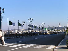
From the port, steps and streets lead up to the Boulevard Che Guevara (formerly Boulevard de la République ), a 2000 meter long terrace with ornamental railings. It was built between 1860 and 1866 according to plans by Morton Peto. The terrace rests on a double row of about 350 arches.
On this boulevard are the palatial buildings of the bank, the post office and the Palace of Justice, at the end of it the Place de la Kasbah (formerly Place de Gouvernement ), and at the same the archbishop's palace, an older Moorish building, and the mosque, completed in 1660 Djamâa el Djedid .
An equestrian statue of Duke Ferdinand Philippe d'Orléans, designed by Charles Marochetti, has stood on the former Place de Gouvernement since 1845 . After independence, the statue was transported to France in 1963 and erected in the municipality of Neuilly-sur-Seine near Paris in 1981 .
To the west of the Boulevard Che Guevara is the National Theater, and in the immediate vicinity is the former Winter Palace of the Governor and the Catholic Cathedral. The Basilica of Our Lady of Africa , accessible by cable car , is located in the Z'ghara district and was completed in 1872.
The Monument of the Martyr ( Maquam E'chahid ) was built in 1984. The 90 meter high structure consists of three palm trees that rest on an extensive esplanade, where the "eternal flame" is located. It is dedicated to the memory of the victims of the struggles for national liberation.
The great mosque of Algiers , inaugurated in November 2020, is considered the third largest mosque in the world.
- Tipasa
Tipasa, a ruined city that was declared a UNESCO World Heritage Site in 1982, is around 50 kilometers west of Algiers . The place was founded by the Phoenicians and expanded by the Romans under Emperor Claudius to a Roman military colony, later it became a municipality .
You can see the ruins of three churches: the Great Basilica and the Basilica of Alexander on the western hill and the Basilica of St. Salsa on the eastern hill. Two cemeteries, the baths, the theater, an amphitheater and the nymphaeum have also been preserved.
The course of the city walls can be clearly seen and at the foot of the eastern hill are the remains of the ancient port. The basilicas are surrounded by cemeteries full of numerous stone coffins decorated with mosaics.
freetime and recreation
About 20 kilometers to the west of Algiers are seaside resorts such as Sidi Fredj (ex-Sidi Ferruch), Palm Beach, Douaouda, Zéralda and Club des Pins (state residence). They are equipped with tourist complexes, Algerian and foreign restaurants, souvenir shops and monitored beaches. The opening of large hotel complexes such as “Hilton”, “El-Aurassi” and “El Djazair” is planned.
Algiers also has the country's first water park. It is located east of the city and has an area of two hectares. There are swimming pools for adults and children as well as a go-kart track, among other things. An expansion by a 1.5 hectare water park is planned. In the east of the city there is also the Botanical Garden ( El-Hamma ) with a zoo and amusement park. It was laid out in 1832 according to plans by A. Hardy. Numerous exotic plants and gardens can be seen on the 80 hectare site.
Sports
Several Algiers football clubs play in the country's first division.
Founded in 1962, CR Belouizdad is one of the most successful football clubs in Algeria with six championships. In addition, the Algerian Cup was won five times in seven finals. The league cup was won in 2000 and the Championnat du Maghreb was won in 1970 and 1971 . The Stade du 20 août 1955 , the venue for the home games, can seat 20,000 spectators.
The USM Algiers club, founded in 1937, has won five national championship titles in its history and won the Algerian Cup seven times in 15 finals. In 1997 and 2003 the club was also in the semi-finals of the CAF Champions League . USM Algiers' venue, the Omar Hammadi Stadium , has a seating capacity of 17,000.
The NA Hussein Dey club, founded in 1947, won the Algerian championship in 1967. In addition, a cup victory was achieved in four finals. In 1978 you were in the final of the African Cup Winners' Cup. The game is played in the Zioui stadium in front of up to 15,000 spectators in yellow and red.
Other football clubs in the capital are MC Algiers , Paradou AC , USM El Harrach , RC Kouba , JHD Algiers , OM Ruisseau and DNC Algiers .
Nouria Mérah-Benida , born in Algiers, is one of four Algerian athletes who have won a gold medal at the Olympic Games . At the XXVII. At the 2000 Summer Olympics in Sydney , Australia , she won the 1500 meter run in front of the two Romanians Violeta Szekely (silver) and Gabriela Szabo (bronze).
From July 11 to 23, 2007, Algiers hosted the 9th African Games , the sports games for the nations of the African continent. Athletes from 53 countries took part in the competitions in Stade 5 Juillet with a capacity of 66,000 . Medals were awarded in 338 disciplines and 22 sports. The 3rd Pan-African Games from July 13-28, 1978 also took place in Algiers.
gastronomy
The restaurants in the Algerian capital offer guests numerous local and international specialties. Typical foods for traditional Algiers cuisine are fish , seafood , sheep and lamb , various vegetables, dates , almonds, olives, grapes and fruit. The dishes are mainly seasoned with cumin, nutmeg, cinnamon and saffron . Fresh peppermint, parsley or coriander are also used .
A main course usually consists of roasted meat (mostly lamb or beef) or fish with couscous (steamed durum wheat semolina) and a vegetable sauce. It is mainly refined with harissa , a hot sauce. Typical dishes are also shakshuba, a stew made from peppers, tomatoes and onions with eggs, and tajine , a stew with lamb. At the food stalls in Algiers you can buy merguez (spicy lamb sausages) and filled baguettes , among other things .
trade
There is a wide range of leather goods, Berber carpets, copper and brass items, local clothing and jewelry in the numerous markets and shops in Algiers. Lacquered wicker, pottery and stoneware are sold from the Sahara. Bargaining is common in the markets and in the smaller shops. Rue Didouche Mourad is one of the main shopping streets.
In the Algerian capital there are two state arts and crafts centers with fixed prices, one of which is located at the airport. The shops usually open from Saturday to Thursday between 8:00 a.m. and 12:00 p.m. and between 2:00 p.m. and 7:00 p.m. The banks open from Sunday to Thursday between 8:00 a.m. and 5:00 p.m.
Economy and Infrastructure
business
Algiers is the most important industrial city in Algeria. Important branches of production are the leather and textile industries, the processing of petroleum and the manufacture of motor vehicles and metal goods. The capital is the seat of the country's largest stock exchange, the Bourse d'Alger.
Intensive agricultural use takes place in the vicinity of the city. Most of the arable and permanent cultivated land is privately owned. The most important agricultural products are cereals, sugar beets, potatoes, legumes, tomatoes, olives, dates, figs, tobacco, wine and citrus fruits. Early vegetables are grown in plastic film greenhouses for export.
After gaining independence, the nationalization of some economic sectors began. Since the early 1980s, however, efforts have been made to liberalize the economy and promote the private sector.
Problems are caused by the inadequate infrastructure and the extremely large housing shortage caused by the rural exodus. The electricity and water supply are in a desolate state. The city has insufficient disposal and purification capacities for sewage, exhaust gases and waste.
There are only a few sewage treatment plants that are often out of order. The wastewater from industry and private households runs unfiltered into the Mediterranean. The water supply of the rivers in the Algerian capital consists of hygienically questionable wastewater, some of which is used for irrigation in agriculture.
In addition to the infectious diseases that are spread due to inadequate hygienic conditions, there are also respiratory and skin diseases due to the toxic emissions from many industrial companies and motor vehicle traffic. Particular problems arise from the often direct neighborhood of poorer residential areas and industry. The air pollution and urban sprawl historically significant areas destroy many cultural monuments Algiers.
traffic
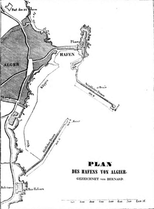
The city is the country's most important transport hub with roads, railways and Algiers Airport . Because of its strategically favorable location and the modern port, it is a center for the export and import of goods and a port of call for refueling ships.
There is an international railway line to Tunisia. Algiers is connected to the east-west motorway . Roads connect Algiers with Tunisia, Libya, Niger, Mali and Mauritania. The border crossing to Morocco is closed. You can take the ferry from the Algerian capital to Spain, France and Italy.
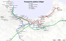
In 2009, an S-Bahn system was opened in Algiers with a speed of 160 kilometers per hour. For this purpose, 64 four-part electric multiple units of the type FLIRT were ordered from Stadler in Switzerland .
The Algiers metro opened on October 31, 2011. The first section of the metro is nine kilometers long and has ten stations. The line runs from the south to the north, then the metro follows the coastline to the west. The line connects Aïn Allah with De Constantine Gué via El-Biar in the city center of Algiers with Aïn Naadja. A further expansion to a total of three lines is planned.
A network of the Algiers tramway complementing the subway was partially put into operation on 8 May 2011 on an 8-kilometer section of the route. An eastern, 30-kilometer-long line is under construction from the city center to Ain Taya and El Kiffan Bordj with 30 stops, as well as a western line between the town of Bab El Oued and Ain Benian (17 kilometers, 20 stations).
Trams operated in the city between 1890 and 1969. Even trolleybuses drove from 1 July 1934-1974 in the Algerian capital.
There are also five cable cars to make it easier to negotiate the sometimes very steep slopes.
media
The Algerian capital is the country's media and publishing center. Almost all of the major radio and television broadcasters and publishers in Algeria are based in Algiers. The city is the seat of the country's official news agency, Algérie Presse Service (APS), founded in 1961. All major foreign news agencies have offices in Algiers, including Agence France-Presse (AFP), Associated Press (AP) and Reuters .
The daily newspapers appearing in the capital with the highest circulation (more than 100,000 copies sold across the country each) are: Al-Moudjahid (founded: 1965, languages: Arabic and French), Al-Badil (founded: 1990, languages: Arabic and French), Le Matin (founded in 1990, language: French) and El Watan (founded in 1990, language: French). The weekly magazine published in Algiers with the highest circulation is Algérie Actualité (founded: 1965, language: French).
The capital is the seat of the state company Radiodiffusion et Télévision Algérienne (RTA). She is responsible for the control of radio and television programs. It is broadcast terrestrially and via satellite in Arabic, French and Tamazight .
education
The city is the seat of the Université d'Alger, which opened in 1909, the Université de Ben Aknoun, the Université de Bouzareah, the Université de la Formation Continue d'Alger, the Université des Sciences et de la Technologie Houari Boumediene and numerous research institutes, high and low Technical schools and libraries. Important schools in the capital are the Ecole Nationale des Travaux publics, the École nationale d'administration and the École normal supérieure des langues et Sciences humaines D'Alger.
Other important educational institutions in Algiers are: Faculté des Sciences Economiques et Sciences de Gestion, INES des sciences commerciales d'Alger, INES Oussoul Eddine d'Alger, Institut national agronomique, Institut National de Recherche Forestière, Institut national d'informatique, Institut Supérieur de the Gestion et de la Planification and Unité de recherche en aménagement du territoire.
There is general compulsory schooling for 6 to 15 year olds. The educational and training differences between men and women are still significant. Adult literacy programs and a higher school enrollment rate have resulted in a gradual decline in the illiteracy rate over the past few decades .
Personalities
The following persons were connected with or worked in Algiers:
- Albert Camus (1913-1960), French writer (1957 Nobel Prize in Literature)
- Camille Saint-Saëns (1835–1921), French composer
Movies
- Pépé le Moko - In the Dark of Algiers (1937), by Julien Duvivier , gangster film of documentary value about the Kasbah
- Algiers (1938), an Oscar-nominated remake of Pépé le Moko by John Cromwell
- La battaglia di Algeri - Battle of Algiers (1966), by Gillo Pontecorvo about the Algerian struggle for independence in Algiers
- Bab el Oued City - Farewell to Algiers (1994), by Merzak Allouache, snapshot of the Algiers of the incipient crisis
- Viva Laldjérie - Long live Algeria (2003), by Nadir Moknèche, portrait of three women in modern Algiers
See also
literature
- Ernle Bradford: The sultan's admiral: the life of Barbarossa . Hodder & Stoughton, London 1968, ISBN 0-340-02504-2
- Stephen Clissold: The Barbary Slaves . Rowman and Littlefield, 1977, ISBN 0-236-40084-3
- Geophysical Research Letters, Vol. 31, 2004: The 21 May 2003 Zemmouri (Algeria) earthquake Mw 6.8: Relocation and aftershock sequence analysis
- Ulrich Haarmann (ed.): History of the Arab world . Verlag CH Beck, Munich 1987, ISBN 3-406-31488-0
- Jörg Manfred Mössner : The international legal personality and the international law practice of the barbarian states (Algiers, Tripoli, Tunis 1518-1830) . Verlag Walter de Gruyter, Berlin 1968
- Bernhard Schmid : Algeria - Frontline State in Global War? Neoliberalism, Social Movements and Islamist Ideology in a North African Country . Unrast Verlag, Münster 2005, ISBN 3-89771-019-6
- Bernhard Schmid: Colonial Algeria . Unrast Verlag, Münster 2006, ISBN 3-89771-027-7
- John B. Wolf: The Barbary Coast: Algeria under the Turks . WW Norton & Co Ltd., New York 1979, ISBN 0-393-01205-0
Web links
- Goethe Institute Algiers
- Own illustration of the extremely large and powerful Statt Algiers so in Barbaria ligt , around 1720, Munich, Bayerische Staatsbibliothek - Einblatt XI, 670
Individual evidence
- ↑ World Gazetteer: Population figures in the core city ( Memento from January 6, 2013 in the web archive archive.today )
- ↑ World Gazetteer: Population figures of the province ( Memento from January 6, 2013 in the web archive archive.today )
- ↑ http://bevoelkerungsstatistik.de/wg.php?x=1200446930&men=gpro&lng=de&dat=80&geo=456390304&srt=npan&col=aohdq&msz=1500&geo=-1048846 (link not available)
- ↑ UNESCO: Entry of the Kasbah in the World Heritage List
- ^ K. Schlemmer: Geographical names. Dogma, 2012, ISBN 3-95454-628-0 , p. 10
- ↑ International Institute of Seismology and Earthquake Engineering: List of important earthquakes in Algeria
- ↑ Mediterranean Storms - The November 9-10, 2001 Algerian Flood - A Polar Low? ( Memento from October 8, 2015 in the Internet Archive ) EarthStation.de (Proceedings of the 4th EGS Plinius Conference held at Mallorca, Spain, October 2002)
- ^ Martin Rheinheimer: From Amrum to Algiers and Back: The Reintegration of a Renegade in the Eighteenth Century. Cambridge University , accessed June 4, 2021 .
- ↑ Cf. Baber Johansen: Contingency in a Sacred Law. Legal and Ethical Norms in the Muslim Fiqh . Leiden et al. 1999. pp. 72, 107-118.
- ↑ a b c d e f Walter Schicho: Handbook Africa - North and East Africa . tape 3/3 . Brandes & Apsel Verlag / Südwind, Frankfurt am Main 2004, ISBN 2-262-01494-9 , p. 79, 90 .
- ↑ a b c d e f Michel Abitbol: Le passé d'une discorde - Juifs et Arabes du VII e siècle à nos jours . Librairie Académique Perrin, Paris 1999, ISBN 2-262-01494-9 , pp. 275, 293 (population figures quoted from figures from the parliamentary commission of inquiry Pourquery de Boisserin from 1900).
- ↑ a b c d Michel Abitbol: Histoire des juifs . In: Marguerite de Marcillac (ed.): Collection tempus . 2nd Edition. No. 663 . Editions Perrin, Paris 2016, ISBN 978-2-262-06807-3 , pp. 613 f .
- ↑ la fusillade de la rue d'Isly à Alger ( Memento of August 4, 2012 in the web archive archive.today ), Ligue des droits de l'homme , March 2002
- ↑ Bernard A. Cook (Ed.): Europe since 1945. An encyclopedia, Vol. 1. Garland, New York 2001. P. 398 ff. ISBN 0-8153-1336-5 .
- ↑ Blast at Algiers Airport Kills 9 and Wounds 100 . New York Times, August 27, 1992
- ^ After attacks - search for assassins in Algiers . n-tv, April 12, 2007
- ↑ Focus: UN staff among the victims of the attack , December 11, 2007
- ↑ Al-Qaeda is committed to the double attack . Zeit Online , December 12, 2007
- ↑ aidlr.org: Algeria: Mission among Muslims is now a punishable offense ( memento of August 10, 2016 in the Internet Archive ), April 3, 2006
- ^ Notre Dame d'Afrique and Carmelite Convent, Algiers, Algeria . In: World Digital Library . 1899. Retrieved September 25, 2013.
- ↑ FAZ.net: Controversial long-range effect
- ↑ UNESCO: Entry of Tipasa in the World Heritage List
- ↑ FLIRT started in Algeria . ( Memento from January 19, 2012 in the Internet Archive ) stadlerrail.com, May 12, 2009; Retrieved January 24, 2011
- ↑ First metro line in the Algerian capital begins passenger service . Siemens, October 31, 2011.
- ^ Tramway d'Alger: Inauguration du 1er tronçon devant un parterre de responsables . Djazairess, May 8, 2011
- ^ Delivery of the first section of the Algiers tramway . Alstom, December 22, 2010


