Witzenhausen district
| coat of arms | Germany map | |
|---|---|---|

|
Coordinates: 51 ° 20 ' N , 9 ° 51' E |
|
| Basic data (as of 1973) | ||
| Existing period: | 1821-1973 | |
| State : | Hesse | |
| Administrative region : | kassel | |
| Administrative headquarters : | Witzenhausen | |
| Area : | 425.82 km 2 | |
| Residents: | 50,800 (Dec. 31, 1972) | |
| Population density : | 119 inhabitants per km 2 | |
| License plate : | WIZ | |
| Circle key : | 06 2 43 | |
| Circle structure: | 29 municipalities | |
The district Witzenhausen was a circle Witzenhausen to 1866 a Kurhessischer , then until 1945, a Prussian circle and then as a Hessian district until 1973 a lower territorial unity of the internal administration and from 1885 a municipal self-government body . From 1974, its former area forms the northern part of the Werra-Meißner district in northeastern Hesse and includes the cities of Witzenhausen , Bad Sooden-Allendorf , Großalmerode , Hessisch Lichtenau , the community of Neu-Eichenberg and the Kaufunger Wald estate. The seat of the district was the city of Witzenhausen.
geography
At the end of 1973 the district bordered in a clockwise direction in the northwest with the Göttingen district in Lower Saxony , the Heiligenstadt district in the Erfurt district of the GDR and the Hessian districts of Eschwege , Melsungen and Kassel .
history
Kurhessen
The district of Witzenhausen was established in 1821 by an electoral ordinance (§ 137) after the separation of the judiciary (§§ 36 ff. Of the ordinance) and administration (§§ 58 et seq. Of the ordinance) as a territorial unit of the Electorate of Hesse for internal administration former offices of Allendorf , Lichtenau , Ludwigstein , Großalmerode and Witzenhausen were formed. The ordinance on the new organization of state administration divided the national territory into four provinces, each province was again divided into circles (§ 1) ( Niederhessen into ten, Oberhessen , Fulda and Hanau into four each).
On January 1, 1837, the communities of Dudenrode , Kammerbach and Orferode moved from the Eschwege district to the Witzenhausen district.
Prussia - The district in the new administrative district of Kassel 1867
The electorate was defeated in the war between Prussia and the German Confederation ( German War , formerly also known as the Prussian-Austrian War). With the law of September 20, 1866, the electorate was united with the Prussian monarchy ( annexation ); the possession takes place on October 3rd, 1866. Since a new Prussian province with corresponding administrative districts was to emerge only “in the future”, the four provinces of the Electorate of Hesse initially continued to exist. But just a few months later, on February 22, 1867, the King of Prussia decreed: From the former Electorate of Hesse, the previously Bavarian territorial parts, District Office Gersfeld and District Court Orb without aura , from the previous Grand Ducal Hessian District of Vöhl , including the enclaves Eimelrod and Höringhausen , an administrative district is formed under the name "Administrative Region Kassel" .
The new (Prussian) administrative district of Kassel was divided into 23 districts, the previous Prussian civil commissioners for Kurhessen and Nassau thus became regional presidents in Kassel and Wiesbaden. The amalgamation of the two administrative districts in the province of Hessen-Nassau was completed on December 22, 1868; Eduard von Möller became the chief president based in Kassel .
After 1945: The new state of Hesse
A territorial exchange took place within the framework of the Wanfrieder Agreement on September 17, 1945:
- The four communities Asbach , Sickenberg , Vatterode and Weidenbach moved from the Witzenhausen district to the Worbis district in the Soviet occupation zone .
- The two communities Neuseesen and Werleshausen moved from the district of Worbis to the district of Witzenhausen.
At the beginning of the 1970s, the outer borders of the district changed several times:
- On December 1, 1970, the municipality of Wickenrode left the district and was incorporated into the municipality of Helsa-Wickenrode in the Kassel district.
- On December 31, 1971, the communities Harmuthsachsen and Hasselbach left the district and were incorporated into the community Waldkappel in the district of Eschwege.
- On August 1, 1972, the municipality of St. Ottilien left the district and was incorporated into the municipality of Helsa in the Kassel district.
As part of the regional reform , the districts of Eschwege and Witzenhausen were merged on January 1, 1974 to form the Werra-Meißner district .
Population development
| year | Residents | source |
|---|---|---|
| 1871 | 31,122 | |
| 1890 | 29,256 | |
| 1900 | 31,055 | |
| 1910 | 32,585 | |
| 1925 | 35,228 | |
| 1939 | 37,262 | |
| 1950 | 56,658 | |
| 1960 | 51,900 | |
| 1970 | 53,000 | |
| 1972 | 50,800 |
politics
District administrators
- 1821–1832 Karl Wilhelm Philipp Bockwitz (district councilor)
- 1856–1868 Wilhelm Uloth
- 1868–1875 Thomas Boch
- 1875–1884 Friedrich Bernstein
- 1884–1895 Bernhard von Schenck
- 1895–1917 Heino von Bischoffshausen
- 1917–1919 Hermann Wolf
- 1919–1928 Georg Thöne ( SPD )
- 1928–1932 Jean Groeniger
- 1932–1938 Ernst Beckmann ( DVP , from 1933 NSDAP )
- 1938–1945 Walter Gerber (NSDAP)
- 1946–1973 Wilhelm Brübach (SPD)
coat of arms
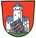
In the coat of arms was Ludwigstein displayed, which was integrated into the arms of the Werra-Meissner circle.
Communities
As of 1969
Until the first municipal mergers in 1970, the district of Witzenhausen consisted of 57 municipalities, four of which had city rights:
As of December 31, 1973
On February 1, 1971, the new municipality of Neu-Eichenberg was created through the merger of several municipalities . After a series of further parish mergers, there were still 29 parishes in the Witzenhausen district at the time of its dissolution on December 31, 1973:
|
|
|
|
Simultaneously with the dissolution of the district, numerous other incorporations took place on January 1, 1974. With Bad Sooden-Allendorf, Großalmerode, Hessisch Lichtenau, Neu-Eichenberg and Witzenhausen, five communities from the old district of Witzenhausen joined the new Werra-Meißner district.
License Plate
On July 1, 1956, the district was assigned the distinctive sign WIZ when the vehicle registration number that is still valid today was introduced . It was issued until December 31, 1973. Since September 16, 2013 it has been available again in the Werra-Meißner district due to the license plate liberalization .
literature
- Witzenhausen district . In: Hessischer Heimatbund (Hrsg.): Handbuch des Hessischer Heimatbundes . tape IV . JA Koch Buchdruckerei, Marburg ad Lahn 1971, p. 229 .
- Albrecht Eckhardt: Small territorial history of the district Witzenhausen. Part II . In: Werratalverein Eschwege e. V. (Ed.): The Werraland . Issue 3. Eschwege 1971, p. 38-43 .
- Ernst Baier, Cord Peppler-Lisbach, Volker Sahlfrank: The flora of the old district of Witzenhausen with the Meißner and Kaufunger forest . 2nd, supplemented and improved edition. Writings of the Werratal Association Witzenhausen, issue 39.Werratal Association (WTV) Witzenhausen, Witzenhausen 2005, ISBN 3-9807194-2-1
- W. Küther: Historical local dictionary of the district of Witzenhausen. (Historical local dictionary of the state of Hesse 1) Marburg 1973
Web links
- Witzenhausen district administrative history and the district administrators on the website territorial.de (Rolf Jehke), as of February 19, 2014.
- Werra-Meißner district
- City of Witzenhausen
- Law on the reorganization of the districts of Eschwege and Witzenhausen (GVBl. I 1973, 353)
Individual evidence
- ↑ Ordinance of June 29, 1821 on the restructuring of the previous state administration , in (collection of laws, ordinances, notices and other general orders for Kurhessen from the year 1821, court and orphanage printer, Cassel) kurhess GS 1821, p. 29 -62; also in: Wilhelm Möller and Karl Fuchs (eds.): Collection of the legal provisions still valid in the Electorate of Hesse from 1813 to 1860. Elwert'sche Universitäts-Buchhandlung, Marburg and Leipzig 1866, pp. 311–351
- ↑ Ordinance of November 5, 1836, concerning the change in some sub-court and district authority districts. In (collection of laws, ordinances, tenders and other general orders for Kurhessen from 1821, court and orphanage printing works, Cassel) kurhess GS 1836, p. 132
- ↑ Ulrich Reuling : Administrative division 1821-1955. (PDF) In: Historical Atlas of Hesse. Landesgeschichtliches Informationssystem Hessen (LAGIS), p. 176 , accessed on March 19, 2016 .
- ^ Law on the unification of the Kingdom of Hanover, the Electorate of Hesse, the Duchy of Nassau and the Free City of Frankfurt with the Prussian Monarchy of September 20, 1866, Collection of Laws for the Royal Prussian States ( Prussian GS) 1866 p. 555 f.
- ^ Patent for taking possession of the former Electorate of Hesse from October 3, 1866, Collection of Laws for the Royal Prussian States ( prussian GS), 1866, p. 594 ff.
- ↑ § 1 sentence 1 of the ordinance concerning the organization of the administrative authorities in the former Electorate of Hesse, in the former Duchy of Nassau, in the formerly free city of Frankfurt and in the previously Bavarian and Grand Ducal Hessian areas. From February 22, 1867 (Collection of Laws for the Royal Prussian States ( prussian GS), 1867 p. 273)
- ^ Federal Statistical Office (ed.): Historical municipality directory for the Federal Republic of Germany. Name, border and key number changes in municipalities, counties and administrative districts from May 27, 1970 to December 31, 1982 . W. Kohlhammer, Stuttgart / Mainz 1983, ISBN 3-17-003263-1 , p. 410 .
- ^ The municipalities and manor districts of the Hesse-Nassau province and their population in 1871
- ↑ a b c d e f g Michael Rademacher: German administrative history from the unification of the empire in 1871 to the reunification in 1990. witzenhausen.html. (Online material for the dissertation, Osnabrück 2006).
- ↑ Statistical Yearbook for the Federal Republic of Germany 1972
- ↑ Statistical Yearbook for the Federal Republic of Germany 1974
- ^ Eckhart G. Franz and Georg Rösch The district administrators in 150 years in the Gelnhausen district: Thomas Boch in 150 years in the Gelnhausen district - home yearbook of the Gelnhausen district - between Vogelsberg and Spessart 1971, Gelnhausen 1970, p. 38
- ↑ a b Werra-Meißner district. Historical local dictionary. In: Landesgeschichtliches Informationssystem Hessen (LAGIS).


