
Lawrence County, Illinois
 The Lawrence County Courthouse in Lawrenceville, listed on the NRHP since 2010 under number 10000992 |
|
| administration | |
|---|---|
| US state : | Illinois |
| Administrative headquarters : | Lawrenceville |
| Address of the administrative headquarters: |
County Courthouse 1100 State Street Lawrenceville, IL 62439-2341 |
| Foundation : | January 16, 1821 |
| Made up from: |
Crawford County Edwards County |
| Area code : | 001 618 |
| Demographics | |
| Residents : | 16,833 (2010) |
| Population density : | 17.5 inhabitants / km 2 |
| geography | |
| Total area : | 968 km² |
| Water surface : | 5 km² |
| map | |
 |
|
| Website : www.lawrencecountyillinois.com | |
The Lawrence County is a county in the US -amerikanischen State Illinois . In 2010 , the county had 16,833 residents and a population density of 17.5 people per square kilometer. The county seat is Lawrenceville .
geography
The county is located in southeast Illinois on the Wabash River , which forms the border with Indiana . It has an area of 968 square kilometers, of which five square kilometers are water. The following neighboring counties border Lawrence County:
| Crawford County | ||
| Richland County |
.svg)
|
Knox County, Indiana |
| Wabash County |
history

| Population development | |||
|---|---|---|---|
| Census | Residents | ± in% | |
| 1830 | 3668 | - | |
| 1840 | 7092 | 93.3% | |
| 1850 | 6121 | -13.7% | |
| 1860 | 9214 | 50.5% | |
| 1870 | 12,533 | 36% | |
| 1880 | 13,663 | 9% | |
| 1890 | 14.093 | 3.1% | |
| 1900 | 16,523 | 17.2% | |
| 1910 | 22,661 | 37.1% | |
| 1920 | 21,380 | -5.7% | |
| 1930 | 21,885 | 2.4% | |
| 1940 | 21,075 | -3.7% | |
| 1950 | 20,539 | -2.5% | |
| 1960 | 18,540 | -9.7% | |
| 1970 | 17,522 | -5.5% | |
| 1980 | 17,807 | 1.6% | |
| 1990 | 15,972 | -10.3% | |
| 2000 | 15,452 | -3.3% | |
| 2010 | 16,833 | 8.9% | |
| Before 1900 1900–1990 2000 2010 | |||
Lawrence County was formed on January 16, 1821 from parts of Edwards County and Crawford County. It was named after Captain James Lawrence , who became famous with the saying: "Don't give up the ship" in the British-American War of 1812 after he was fatally wounded.
The Wabash River was a popular route for the French to travel from Canada to the Mississippi River and on to the Gulf of Mexico in the late 17th and mid-18th centuries . The French secured this route through various military posts. In the Peace of Paris in 1783 the territory fell to the British.
On February 18, 1779, George Roger Clark and his soldiers crossed what would later become Lawrence County, crossed the Wabash River near St. Francisville and captured Fort Vincennes on February 25, 1779 . After the war of 1812, more settlers came from Ohio , Kentucky, and Indiana . In the following years a ferry was built across the Wabash River, roughly at the site of today's Lincoln River Bridge .
In March 1830 the then 21-year-old future President Abraham Lincoln crossed the Wabash River with his entire family in ox-drawn carts. Later, as a prosecutor, he made frequent visits to the county.
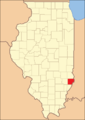
Territorial development
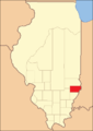
Lawrence County from its inception in 1821 to 1824

1824 to 1841
1841 until today


Demographic data
As of the 2010 census , there were 16,833 people in 5,818 households in Lawrence County. The population density was 17.5 inhabitants per square kilometer. Statistically, 2.18 people lived in each of the 5818 households.
The racial the population was composed of 88.5 percent white, 10.0 percent African American, 0.3 percent Native American, 0.3 percent Asian and other ethnic groups; 0.9 percent were descended from two or more races. Regardless of ethnicity, 3.5 percent of the population was Hispanic or Latino of any race.
19.2 percent of the population were under 18 years old, 65.2 percent were between 18 and 64 and 15.6 percent were 65 years or older. 43.9 percent of the population was female.
The median income for a household was 38,326 USD . The per capita income was $ 17,050. 16.2 percent of the population lived below the poverty line.
Lawrence County localities
1 - partially in Crawford County
structure
Lawrence County is divided into nine townships :
| Township | Population (2010) |
FIPS |
|---|---|---|
| Allison Township | 267 | 17-00906 |
| Bond Township | 685 | 17-07198 |
| Bridgeport Township | 2420 | 17-08199 |
| Christy Township | 3774 | 17-14299 |
| Denison Township | 1558 | 17-19395 |
| Lawrence Township | 6521 | 17-42379 |
| Lukin Township | 429 | 17-45200 |
| Petty Township | 729 | 17-59377 |
| Russell Township | 450 | 17-66378 |
See also
Individual evidence
- ↑ GNIS-ID: 424252. Retrieved on February 22, 2011 (English).
- ↑ a b c U.S. Census Bureau, State & County QuickFacts - Lawrence County, IL ( Memento of the original from July 13, 2011 on WebCite ) Info: The archive link was automatically inserted and not yet checked. Please check the original and archive link according to the instructions and then remove this notice. Retrieved December 16, 2012
- ↑ a b National Association of Counties.Retrieved December 16, 2012
- ^ US Census Bureau - Census of Population and Housing.Retrieved March 15, 2011
- ^ Extract from Census.gov.Retrieved February 15, 2011
- ↑ Missouri Census Data Center - Illinois ( page no longer available , search in web archives ) Info: The link was automatically marked as defective. Please check the link according to the instructions and then remove this notice. Retrieved December 16, 2012
Web links
List of counties in Illinois
Adams |
Alexander |
Bond |
Boone |
Brown |
Bureau |
Calhoun |
Carroll |
Cass |
Champaign |
Christian |
Clark |
Clay |
Clinton |
Coles |
Cook |
Crawford |
Cumberland |
DeKalb |
DeWitt |
Douglas |
DuPage |
Edgar |
Edwards |
Effingham |
Fayette |
Ford |
Franklin |
Fulton |
Gallatin |
Greene |
Grundy |
Hamilton |
Hancock |
Hardin |
Henderson |
Henry |
Iroquois |
Jackson |
Jasper |
Jefferson |
Jersey |
Jo Daviess |
Johnson |
Kane |
Kankakee |
Kendall |
Knox |
LaSalle |
Lake |
Lawrence |
Lee |
Livingston |
Logan |
Macon |
Macoupin |
Madison |
Marion |
Marshall |
Mason |
Massac |
McDonough |
McHenry |
McLean |
Menard |
Mercer |
Monroe |
Montgomery |
Morgan |
Moultrie |
Ogle |
Peoria |
Perry |
Piatt |
Pike |
Pope |
Pulaski |
Putnam |
Randolph |
Richland |
Rock Island |
Saline |
Sangamon |
Schuyler |
Scott |
Shelby |
St. Clair |
Strong |
Stephenson |
Tazewell |
Union |
Vermilion |
Wabash |
Warren |
Washington |
Wayne |
White |
Whiteside |
Will |
Williamson |
Winnebago |
Woodford
Coordinates: 38 ° 43 ′ N , 87 ° 44 ′ W