Mauregard (Seine-et-Marne)
| Mauregard | ||
|---|---|---|

|
|
|
| region | Île-de-France | |
| Department | Seine-et-Marne | |
| Arrondissement | Meaux | |
| Canton | Mitry-Mory | |
| Community association | Roissy Pays de France | |
| Coordinates | 48 ° 46 ' N , 3 ° 2' E | |
| height | 76-138 m | |
| surface | 8.76 km 2 | |
| Residents | 353 (January 1, 2017) | |
| Population density | 40 inhabitants / km 2 | |
| Post Code | 77990 | |
| INSEE code | 77282 | |
| Website | www.mauregard.fr | |
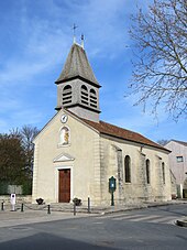
 View of Mauregard |
||
Mauregard is a French municipality with 353 inhabitants (as of January 1 2017) in the department of Seine-et-Marne in the region Ile-de-France . It belongs to the arrondissement of Meaux and the canton of Mitry-Mory (until 2015: canton of Dammartin-en-Goële ). The inhabitants are called the Mauregalois .
geography
Mauregard is about 26 kilometers northeast of Paris . Mauregard is surrounded by the neighboring municipalities of Chennevières-lès-Louvres in the north and north-west, Vémars in the north, Moussy-le-Neuf in the north-east, Moussy-le-Vieux in the east and north-east, Le Mesnil-Amelot in the east and south-east, Tremblay-en -France in the south, Roissy-en-France in the southwest and Épiais-lès-Louvres in the west.
The Charles de Gaulle Airport lies with its eastern half in the municipality.
Population development
| year | 1962 | 1968 | 1975 | 1982 | 1990 | 1999 | 2006 | 2013 |
| Residents | 171 | 163 | 198 | 208 | 226 | 237 | 256 | 335 |
| Source: Cassini and INSEE | ||||||||
Attractions
- Saint-Jean-Baptiste church, rebuilt in 1824
literature
- Le Patrimoine des Communes de la Seine-et-Marne. Flohic Editions, Volume 1, Paris 2001, ISBN 2-84234-100-7 , pp. 405-406.

