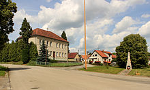
Okrouhlá Radouň
| Okrouhlá Radouň | ||||
|---|---|---|---|---|
|
||||
| Basic data | ||||
| State : |
|
|||
| Region : | Jihočeský kraj | |||
| District : | Jindřichův Hradec | |||
| Area : | 908 ha | |||
| Geographic location : | 49 ° 14 ' N , 15 ° 1' E | |||
| Height: | 625 m nm | |||
| Residents : | 197 (Jan. 1, 2019) | |||
| Postal code : | 378 42 | |||
| License plate : | C. | |||
| traffic | ||||
| Street: | Jindřichův Hradec - Horní Radouň | |||
| structure | ||||
| Status: | local community | |||
| Districts: | 1 | |||
| administration | ||||
| Mayor : | Zdeněk Leitner (as of 2018) | |||
| Address: | Okrouhlá Radouň 82 378 42 Nová Včelnice |
|||
| Municipality number: | 562475 | |||
| Website : | www.okrouhlaradoun.cz | |||
Okrouhlá Radouň (German Disk Radaun ) is a municipality in the Czech Republic with about 200 inhabitants. It is located twelve kilometers north of Jindřichův Hradec and belongs to the Okres Jindřichův Hradec .
geography
Okrouhlá Radouň is located in the south of the Bohemian-Moravian Highlands in the Radouňský potok valley. The 596 m high Kubalov rises north of the village.
Neighboring towns are Horní Radouň in the north, Dívčí Kopy and Hadravova Rosička in the northeast, Karlov and Nová Včelnice in the east, Lovětín in the southeast, Kostelní Radouň in the south and Najdek in the west.
history
The village was first mentioned as villa Raduny in 1389.
In 1782 320 people lived in the village. In the 1820s mining began on limonite , which was first processed in Chlum u Třeboně and later in Kamenice nad Lipou . On August 5, 1839, after a thunderstorm that lasted three hours, the place was flooded and the fish ponds overflowed. In 1860, Scheiben Radaun had 544 residents. In 1896 the volunteer fire brigade was founded .
In Okrouhlá Radouň, as in the neighboring towns of Lodhéřov and Najdek, mostly German-speaking residents lived. Fueled by Henlein's ideas , there were nationality conflicts in the village in 1938. On November 1, 1940, Scheiben Radaun was reclassified together with Kirchen Radaun to the Kamnitz an der Linde district .
After the dissolution of Okres Kamenice nad Lipou, the place came to Okres Jindřichův Hradec on July 1, 1960 . In the same year, Okrouhlá Radouň and Starý Bozděchov merged with Horní Radouň . In 1981 Okrouhlá Radouň received its own local committee again.
Today mining is still carried out on Králův vrch, southeast of the town. The mine at Kublov has been closed.
Community structure
No districts are shown for the municipality of Okrouhlá Radouň.
Attractions
- St. Wenceslas Chapel, built in 1874


