
Pierrepont (Meurthe-et-Moselle)
| Pierrepont | ||
|---|---|---|

|
|
|
| region | Grand Est | |
| Department | Meurthe-et-Moselle | |
| Arrondissement | Briey | |
| Canton | Mont-Saint-Martin | |
| Community association | Terre Lorraine du Longuyonnais | |
| Coordinates | 49 ° 25 ' N , 5 ° 43' E | |
| height | 227-336 m | |
| surface | 7.02 km 2 | |
| Residents | 870 (January 1, 2017) | |
| Population density | 124 inhabitants / km 2 | |
| Post Code | 54620 | |
| INSEE code | 54428 | |
 Mairie Pierrepont |
||

Pierrepont is a French commune with 870 inhabitants (as of January 1, 2017) in the Meurthe-et-Moselle department in the Grand Est region (until 2015 Lorraine ). It belongs to the arrondissement of Briey and the canton of Mont-Saint-Martin (until 2015: canton Longuyon ).
geography
The parish of Pierrepont is located on the Crusnes , a tributary of the Chiers , southeast of Longuyon and south of Longwy .
history
During the First World War , from 1915 to 1918 the military hospital and the cemetery were in Pierrepont, the training ground in the Doncourt forest and the crew quarters of the Rohrschen Sturm- und Lehr-Battalion in Beuveille .
Mainly the dead of the »Storm Battalion No. 5 (Rohr)« were buried in the German military cemetery. The monument, in the form of a lion guarding the dead, was erected during the war and was not removed afterwards.

Saint-Côme and Saint-Damien Church

Allied military cemetery

German military cemetery
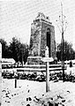
Close up of the monument


Population development
| year | 1962 | 1968 | 1975 | 1982 | 1990 | 1999 | 2007 | 2014 |
| Residents | 1,096 | 1,115 | 1,195 | 1,173 | 1,058 | 984 | 948 | 877 |
Web links
- Pierrepont on www.cc-2rivieres.fr (French)
Individual evidence
- ↑ Eberhard Graf von Schwerin: Royal Prussian Storm Battalion No. 5 (Rohr) (From Germany's great times; Volume 116) recorded after the memory with the help of the diary of Lieutenant Colonel a. D. Willi Rohr / Count v. Schwerin; Sporn, Zeulenroda 1939