
Plaisance (Aveyron)
|
Plaisance Plasença |
||
|---|---|---|
|
||
| region | Occitania | |
| Department | Aveyron | |
| Arrondissement | Millau | |
| Canton | Causses-Rougiers | |
| Community association | Saint Affricain, Roquefort, Sept Vallons | |
| Coordinates | 43 ° 56 ' N , 2 ° 33' E | |
| height | 229-647 m | |
| surface | 14 km 2 | |
| Residents | 221 (January 1, 2017) | |
| Population density | 16 inhabitants / km 2 | |
| Post Code | 12550 | |
| INSEE code | 12183 | |
 Town Hall (Mairie) of Plaisance |
||

Plaisance ( Occitan Plasença ) is a place and a municipality in the south of France with 221 inhabitants (as of January 1, 2017) in the Aveyron department in the Occitania region (before 2016 Midi-Pyrénées ). Coupiac belongs to the Arrondissement of Millau and the canton of Causses-Rougiers ( Saint-Sernin-sur-Rance until 2015 ). The inhabitants are called Plaisançais .
location
Plaisance is about 38 kilometers east of Albi in the southwest of the historic Rouergue province . Plaisance is surrounded by the neighboring municipalities of Coupiac in the north and east, Balaguier-sur-Rance in the south, Curvalle in the west and La Bastide-Solages in the north-west.
history
From 1833 to 1874 Plaisance was part of La Bastide-Solages.
Population development
| year | 1962 | 1968 | 1975 | 1982 | 1990 | 1999 | 2006 | 2013 |
| Residents | 403 | 318 | 280 | 282 | 228 | 228 | 230 | 201 |
| Source: Cassini and INSEE | ||||||||
Attractions
- Saint-Martin church, monument historique since 1929
- Saint-Eutrope crossroads, a historic monument since 1929
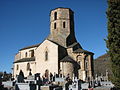
Saint Martin Church

Crossroads of Saint-Eutrope

