
KwaZulu-Natal
| KwaZulu-Natal | ||
|---|---|---|
  |
||
| Symbols | ||
|
||
|
Motto "Masisukume sakhe" |
||
| Basic data | ||
| Country | South Africa | |
| Capital | Pietermaritzburg | |
| surface | 94,361 km² | |
| Residents | 10,267,300 (2011) | |
| density | 109 inhabitants per km² | |
| ISO 3166-2 | ZA-KZN | |
| Website | www.kznonline.gov.za (English) | |
| politics | ||
| prime minister | Willie's Mchunu | |
| Political party | ANC | |

Coordinates: 28 ° 32 ' S , 30 ° 54' E
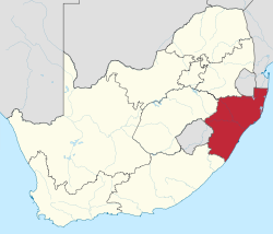
KwaZulu-Natal (Natal stressed on the second syllable) is a province on the east coast of South Africa . It borders in the north on Swaziland , Mozambique and Mpumalanga , in the south on the Eastern Cape , in the west on Lesotho and the Free State and in the east on the Indian Ocean . The province was created in 1994 from the merger of the former homeland KwaZulu and the former province of Natal . It encompasses the traditional settlement area of the Zulu and is the only province that has an ethnic group in its name.
geography

KwaZulu-Natal is called the garden province of South Africa. The landscape can be divided into three zones: flat coastal areas, hilly plains inland and two mountain zones: the Drakensberg in the west and the Lebomboberge in the north. The climate is generally warm and humid, but in the higher inland it can get very dry and quite cold in winter. There used to be tropical forests in the coastal strip - today sugar cane and tropical fruits are often planted here.
The sandy beaches on the north coast (north of Durban ) and on the south coast (south of Durban) with their warm water are popular holiday destinations for many residents and foreigners. Only a few larger bays offered the natural prerequisite for the construction of seaports .
Districts with the parishes
The province is divided into the following ten districts with 43 local parishes and one metropolitan municipality :
.svg)
| District / Metropolitan Municipality | Communities | |
|---|---|---|
| 1. | Amajuba | Dannhauser , eMadlangeni and Newcastle |
| 2. | Harry Gwala (formerly Sisonke ) | Dr Nkosazana Dlamini Zuma , Greater Kokstad , Ubuhlebezwe and Umzimkhulu |
| 3. | iLembe | KwaDukuza , Mandeni , Maphumulo and Ndwedwe |
| 4th | King Cetshwayo (formerly uThungulu ) | City of uMhlathuze , Mthonjaneni , Nkandla , uMfolozi and uMlalazi |
| 5. | Ugu | Ray Nkonyeni , uMdoni , uMuziwabantu and Umzumbe |
| 6th | umgungundlovu | Impendle , Mkhambathini , Mpofana , Msunduzi , Richmond , uMngeni and uMshwathi |
| 7th | uMkhanyakude | Big Five Hlabisa , Jozini , Mtubatuba and Umhlabuyalingana |
| 8th. | uMzinyathi | Endumeni , Msinga , Nquthu and Umvoti |
| 9. | uThukela | Alfred Duma , Inkosi Langalibalele and Okhahlamba |
| 10. | Zululand | AbaQulusi , eDumbe , Nongoma , Ulundi and uPhongolo |
| 11. | eThekwini | Metropolitan municipality |
Cities
- Durban was originally called Port Natal and existed when the Boers came to Natal in 1838. The city was later renamed after the British Governor d'Urban. Today Durban is the largest city in KwaZulu-Natal with a population of two million. Kloof and Hillcrest are in the vicinity .
- Pietermaritzburg was founded by the Boers in 1838 as the capital of their Republic Natalia . From 1994 to 2004 it shared the title of provincial capital with the traditional capital of Zululand , Ulundi .
Other cities are Newcastle , Dundee , Vryheid (Freedom) and Hluhluwe in the north of the province, Port Shepstone and Kokstad in the south.
politics


In the 2019 elections to the Provincial Legislature , the ANC remained the strongest party in KwaZulu-Natal. The Inkatha Freedom Party took on the role of the official opposition. The mandates are distributed as follows.
| Political party | Seats | +/- |
|---|---|---|
| African National Congress (ANC) | 44 | −8 |
| Inkatha Freedom Party (IFP) | 13 | +4 |
| Democratic Alliance (DA) | 11 | +1 |
| Economic Freedom Fighters (EFF) | 8th | +6 |
| National Freedom Party (NFP) | 1 | −5 |
| Minority Front (MF) | 1 | ± 0 |
| African Transformation Movement (ATM) | 1 | +1 |
| African Christian Democratic Party (ACDP) | 1 | +1 |
| total | 80 |
population

The Zulu make up the majority of the population . They speak isiZulu , a Bantu language. The tribes that lived in the area of today's province were united into one people by the Zulu king Shaka in the 19th century .
Although the Republic of Natalia was founded by Buren, today the English share predominates in the European minority in KwaZulu-Natal. The Boers continued to move inland after the United Kingdom annexed Natal in 1842 . As a result, many British immigrants settled in this fertile area.
The settlement efforts were particularly favored in the area around the Bay of Natal , today's Durban, where the port of Durban has gradually developed since the 19th century . The office of harbor master has been handed down here since 1840. An orderly development of today's port area did not begin until 1855.
Since the second half of the 19th century, numerous Indians were recruited as workers for the sugar cane plantations in South Africa. Most of these later moved to the cities. They make up the majority of the Hindus in South Africa; but there are also Muslims among them. Durban is the city with the largest Indian population outside of the Indian subcontinent.
It could also be German immigrants settled in what is now KwaZulu-Natal. German-speaking South Africans still live in the area around Wartburg , Harburg and Hermannsburg .
Population development
The following overview shows the population by area since the 1996 census.
| year | population |
|---|---|
| 1996 (census) | 8,572,302 |
| 2001 (census) | 9,584,129 |
| 2011 (census) | 10,267,300 |
| 2018 (estimate) | 11,384,700 |
Parks and nature reserves

National parks
- iSimangaliso Wetland Park ( World Heritage Site )
- uKhahlamba Drakensberg Park (World Heritage Site)
- Hluhluwe iMfolozi Park
Nature reserves
|
|
|
economy
Industry
The industrialization of the province has developed strongly in several places. This is especially true in the cities of Dundee , Durban, Hammarsdale , Ladysmith , Mandeni , Newcastle , Pietermaritzburg , Richards Bay and Richmond . One focus is the automotive industry with numerous suppliers. The center of the South African aluminum industry is in the Richards Bay region.
The port area near Richards Bay with the surrounding industrial locations and the industrial region Durban with its port, which is important for South Africa's import and export volumes, form particularly pronounced economic focal points with a well-networked transport infrastructure . The Richards Bay Coal Terminal is one of the world's largest loading facilities for coal exports and is supplied by Transnet Freight Rail via the Richards Bay Coal Line .
Mineral raw materials
In Dundee and Newcastle there are coal deposits whose mines their products for the coal terminal in the port of Richards Bay provide. In the north near Pongola there are gold deposits , but these are of minor importance. Furthermore, heavy mineral sands are extracted in coastal areas by Richards Bay Minerals and natural stone types in various locations.
Agriculture
The prevailing climatic conditions in the area of the province, the good availability of water and agriculturally favorable soil conditions have enabled the advantageous development of the agricultural sector over a long period, which is now one of the most important economic factors in the province. The main products are sugar cane and subtropical fruits, which are mainly grown in the coastal region and in some cases supply a processing industry. The focus of cultivation is on bananas , primarily in plantations between Port Shepstone and Port Edward , pineapples in the region around Hluhluwe, and cashew fruits and potatoes .
Farms in the interior of the country deal with the cultivation of vegetables , dairy farming and dairy and other areas of livestock farming . There are tea plantations in the vicinity of Ngome, near Nongoma . Forestry is practiced extensively at Vryheid , Eshowe , Richmond , Harding and Ngome, with eucalyptus , pine , black wattle and poplar among the preferred types of wood. Sappi and Mondi are large and historically located timber producers in KwaZulu-Natal . For traditional wickerwork, craftsmen involved gain fiber plants in their natural locations.
Web links
- Web presence of the KwaZulu-Natal Provincial Administration. on www.kznonline.gov.za (English)
- Municipalities in KZN. at www.kznonline.gov.za Overview of district and local parishes (English)
- Website of the KwaZulu-Natal Tourism Council. on www.kzn.org.za (English)
- List of nature reserves. on www.routes.co.za (English)
Individual evidence
- ↑ Statistics South Africa : Census 2011, Census in brief . online at www.statssa.gov.za (English, PDF file; 2.8 MB), PDF document p. 23, doc. p. 18.
- ^ Local Government Handbook. South Africa: KwaZulu-Natal Municipalities . at www.municipalities.co.za (English).
- ^ Statistics South Africa : Limpopo . on www.statssa.gov.za (English), interactive map.
- ^ Port of Durban (Transnet National Ports Authority). First harbor master . on www.ports.co.za (English)
- ^ Port of Durban. on www.worldportsource.com (English)
- ↑ South Africa: Provinces and Major Settlements - Population Statistics, Maps, Charts, Weather, and Web Information. Retrieved January 7, 2019 .
- ^ A b Province of KwaZulu-Natal: About: The Province of KwaZulu-Natal . on www.kznonline.gov.za ( Memento from April 25, 2015 in the Internet Archive ) (English)
- ^ Council for Geoscience: Summary of Economic Geology of Provinces: Kwa Zulu Natal . on www.geoscience.org.za ( Memento from June 1, 2013 in the Internet Archive )
- ^ A b KwaZulu-Natal Top Business: Agriculture . on www.kzntopbusiness.co.za (English)