Reinoso (Burgos)
| Reinoso municipality | ||
|---|---|---|
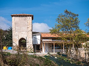
 Reinoso - Church
|
||
| coat of arms | Map of Spain | |
 Help on coat of arms |
|
|
| Basic data | ||
| Autonomous Community : |
|
|
| Province : | Burgos | |
| Comarca : | La Bureba | |
| Coordinates | 42 ° 31 ′ N , 3 ° 23 ′ W | |
| Height : | 860 msnm | |
| Area : | 8.51 km² | |
| Residents : | 15 (Jan. 1, 2019) | |
| Population density : | 1.76 inhabitants / km² | |
| Postal code : | 09248 | |
| Municipality number ( INE ): | 09310 | |
| administration | ||
| Website : | Reinoso | |
Reinoso is a northern Spanish town and a rural municipality ( municipio ) with only 15 inhabitants (as of January 1, 2019) in the north of the province of Burgos in the autonomous community of Castile-León .
Location and climate
The place Reinoso is a good 36 km (driving distance) northwest of the provincial capital Burgos at an altitude of about 860 m ; the town of Miranda del Ebro is about 85 km to the northeast. The lovely town of Briviesca is only 8 km away. The climate in winter is harsh, but in summer it is temperate and warm; Rain (approx. 670 mm / year) falls mainly in the winter half-year.
Population development
| year | 1857 | 1900 | 1950 | 2000 | 2017 |
| Residents | 224 | 166 | 160 | 24 | 12 |
The mechanization of agriculture and the abandonment of small farms has led to a significant decline in the number of inhabitants since the 1950s, so that the place may soon be near its end.
economy
For centuries, the inhabitants of the community lived mainly from agriculture (agriculture, viticulture and small livestock farming) as a self-sufficient living ; only since the middle of the 20th century has it been produced for the national market. Tourism hardly plays a role in the income of the dying community.
history
Reinoso lies a little above the La Bureba corridor, which connected the upper Ebro valley with the Duero valley. The El Pendón dolmen, about 1500 m from the town, testifies to the presence of people during the Neolithic Age . The early modern church tower is an indication of the existence of a settlement at this time.
Attractions
- Of the local church, built in the 16th or 17th century, only the bell tower (campanario) built from precisely carved stones remains . The unadorned baptismal font and two bells can still be found on the ground floor .
- Surroundings
- The El Pendón dolmen , located on a hill about 1.5 km south-east overgrown with gorse, is made of limestone and is correspondingly heavily weathered. All the capstones of the passage grave are missing, but the almost square grave chamber testifies to the planning skills of the builders.
- In the immediate vicinity of the dolmen is a not yet keyed grave mound (tumulus) .
Web links
- Rerinoso - photos + short information (wikiburgos, spanish)
- Reinoso, Dolmen etc. - Video
Individual evidence
- ↑ Cifras oficiales de población resultantes de la revisión del Padrón municipal a 1 de enero . Population statistics from the Instituto Nacional de Estadística (population update).
- ↑ Reinoso - climate tables
- ↑ Reinoso - population development

