
Saint-Denis-le-Ferment
| Saint-Denis-le-Ferment | ||
|---|---|---|
.svg)
|
|
|
| region | Normandy | |
| Department | Your | |
| Arrondissement | Les Andelys | |
| Canton | Gisors | |
| Community association | Vexin Normand | |
| Coordinates | 49 ° 20 ' N , 1 ° 43' E | |
| height | 54-137 m | |
| surface | 18.01 km 2 | |
| Residents | 488 (January 1, 2017) | |
| Population density | 27 inhabitants / km 2 | |
| Post Code | 27140 | |
| INSEE code | 27533 | |
| Website | http://www.saintdenisleferment.fr/ | |

Saint-Denis-le-Ferment is a French municipality with 488 inhabitants (as of January 1 2017) in the Eure in the region of Normandy . It belongs to the arrondissement of Les Andelys and the canton of Gisors . The inhabitants are called Dionysia .
geography
Saint-Denis-le-Ferment is about 76 kilometers east-southeast of Rouen . Saint-Denis-le-Ferment is surrounded by the neighboring communities of Hébécourt in the north, Bazincourt-sur-Epte in the east, Gisors in the south and south-east, Bézu-Saint-Éloi in the west and south-west, Heudicourt in the west and Sancourt in the north-west.
Population development
| year | 1962 | 1968 | 1975 | 1982 | 1990 | 1999 | 2006 | 2013 |
| Residents | 242 | 174 | 214 | 298 | 405 | 456 | 454 | 504 |
| Source: Cassini and INSEE | ||||||||
Attractions
- Saint-Denis church from the 12th / 13th centuries Century, since 1927 Monument historique
- Former priory of Sainte-Austreberthe from the 13th century
- 16th century mansion of Montalègre, a historic monument since 1921
- Le Coudray mansion from the 16th century, alterations from the 18th century
- Saint-Paër Mill from the 18th century
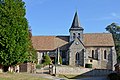
Saint-Denis church

Gate to the manor of Montalègre
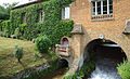
Saint-Paër Mill


Web links
Commons : Saint-Denis-le-Ferment - Collection of images, videos and audio files