Fains
| Fains | ||
|---|---|---|

|
|
|
| region | Normandy | |
| Department | Your | |
| Arrondissement | Les Andelys | |
| Canton | Pacy-sur-Eure | |
| Community association | Its Normandy agglomeration | |
| Coordinates | 49 ° 0 ′ N , 1 ° 23 ′ E | |
| height | 40-126 m | |
| surface | 3.77 km 2 | |
| Residents | 440 (January 1, 2017) | |
| Population density | 117 inhabitants / km 2 | |
| Post Code | 27120 | |
| INSEE code | 27231 | |
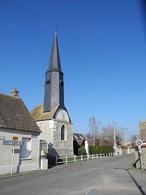
 Saint-Pierre church |
||
Fains is a French municipality with 440 inhabitants (at January 1, 2017) in the Eure in the region of Normandy .
geography
Fains is located between Gadencourt in the south and Pacy-sur-Eure in the north, 13 kilometers southwest of Vernon on the N13 at the western end of the Eure department. The river Eure and the brook Le Bras du Fains flow through the municipality, which also has several ponds . The hamlets of La Noë du Bois, La Gènevraie, La Cave-à-Renoult, Les Closets and Le Moulin belong to the municipality.
history
Nègre assumes that the homonymous municipality of Fains in the Meuse department is named after a term from the Langues d'oïl . Fain means "boggy moor" or "muddy meadow". Le Prévost assumes that the place name Fains (Eure), just like the place names Feings , Feins , Fins and Les Fins , originated from the Latin word fines ("area" or "country"). Fains in Eure was located on an area border that was marked by the Eure, while the place name Fains in the Meuse department originated differently.
In the register of fiefdoms at the time of Philip II of France (1165-1223) Fains is mentioned as a fiefdom of Pacy-sur-Eure. The residents of Fains had certain rights over the Merey Forest . Fains was owned by a seigneur . The Abbey at La Croix-Saint-Leufroy owned land in Fains.
Attractions
The Romanesque church of Saint-Pierre was rebuilt in the 16th century. It has been restored several times since then. The church has a 16th century choir desk and a statue of the Virgin and Child , classified as Monuments historiques in 1907 . A bell dated 1553 was classified as a monument historique in 1994. There are also remains of the liter funéraire with three coats of arms in the church . They are the coats of arms of Barthélemy du Chesne, Écuyer (attested in 1666), and his wife Catherine Marie Gabrielle de la Vallée des Lettiers from the end of the 17th century.
A former mill was later converted into chocolate production ( chocolaterie Moreuil ) and is now used as a residential building.
Population development
- 1962: 189
- 1968: 209
- 1975: 286
- 1982: 296
- 1990: 355
- 1999: 327
- 2007: 416
- 2016: 440
economy
Protected Geographical Indications (IGP) apply to pork (Porc de Normandie) , poultry (Volailles de Normandie) and cider (Cidre de Normandie and Cidre normand) in the municipality .
Personalities
- René II (1451–1508), Duke of Lorraine
Web links
Individual evidence
- ↑ a b Le village de Fains. In: Annuaire-Mairie.fr. Retrieved July 21, 2012 (French).
- ^ A b Daniel Delattre, Emmanuel Delattre: L'Eure, les 675 communes . Editions Delattre, Grandvilliers 2000, pp. 108 (French).
- ^ Ernest Nègre: Toponymie générale de la France . tape 2 . Librairie Droz, 1996, ISBN 2-600-00133-6 , pp. 952 (French, limited preview in Google Book search).
- ↑ Auguste Le Prevost : Mémoires et notes de M. Auguste Le Prevost pour servir à l'histoire du département de l'Eure . Ed .: Léopold Delisle , Louis Paulin Passy. tape 2 . Auguste Herissey, Évreux 1864, p. 75 (French, from Archive.org [accessed June 10, 2010]).
- ↑ Fains in Base Palissy (French) Retrieved November 5, 2009
- ↑ Pierre Bodin: Les liters seigneuriales des églises de l'Eure . Amis des Monuments et Sites de l'Eure, Amis de Bernay, Condé-sur-Noireau 2005, p. 81 f . (French).
- ^ Fains in Base Mémoire (French) Retrieved November 5, 2009
