
Guiseniers
| Guiseniers | ||
|---|---|---|
.svg)
|
|
|
| region | Normandy | |
| Department | Your | |
| Arrondissement | Les Andelys | |
| Canton | Les Andelys | |
| Community association | Its Normandy agglomeration | |
| Coordinates | 49 ° 13 ′ N , 1 ° 28 ′ E | |
| height | 84-158 m | |
| surface | 10.71 km 2 | |
| Residents | 461 (January 1, 2017) | |
| Population density | 43 inhabitants / km 2 | |
| Post Code | 27700 | |
| INSEE code | 27307 | |
 Guiseniers Town Hall (Mairie) |
||

Guiseniers is a French municipality with 461 inhabitants (as of January 1 2017) in the department of Eure in the region of Normandy . It belongs to the Arrondissement of Les Andelys and the Canton of Les Andelys . The inhabitants are called Guisenois .
Neighboring communities
Guiseniers is about 45 kilometers southeast of Rouen . Neighboring municipalities of Guiseniers are Les Andelys in the north and west, Harquency in the north and northeast, Vexin-sur-Epte in the east, Mézières-en-Vexin in the south and Hennezis in the west and south-west.
Population development
| year | 1962 | 1968 | 1975 | 1982 | 1990 | 1999 | 2006 | 2013 |
| Residents | 325 | 289 | 237 | 291 | 388 | 382 | 418 | 445 |
| Source: Cassini and INSEE | ||||||||
Attractions
- Saint-Denis church from the 12th century, monument historique since 1954
- Rectory
- 16th century mansion, monument historique since 1954
- 17th century mansion La Bucaille

Saint-Denis church
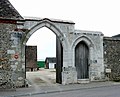
Portal of the manor


Web links
Commons : Guiseniers - collection of images, videos and audio files