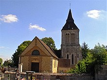
Heudebouville
| Heudebouville | ||
|---|---|---|
|
|
||
| region | Normandy | |
| Department | Your | |
| Arrondissement | Les Andelys | |
| Canton | Louviers | |
| Community association | His-yours | |
| Coordinates | 49 ° 12 ′ N , 1 ° 14 ′ E | |
| height | 8–151 m | |
| surface | 9.28 km 2 | |
| Residents | 788 (January 1, 2017) | |
| Population density | 85 inhabitants / km 2 | |
| Post Code | 27400 and 27600 | |
| INSEE code | 27332 | |
| Website | http://www.heudebouville.fr/ | |
 Mairie Heudebouville |
||
Heudebouville is a French city with a population of 788 (as at 1st January 2017) in the Eure in the region of Normandy . It belongs to the arrondissement of Les Andelys and the canton of Louviers (until 2015: canton of Louviers-Nord ). The inhabitants are called Heudebouvillais .
geography
Heudebouville lies on the banks of the Seine . Heudebouville is surrounded by the neighboring communities of Vironvay in the north and north-west, Muids in the north-east, Venables in the east, Fontaine-Bellenger in the south and south-east, Acquigny in the south-west and Pinterville in the west.
The A13 car route leads through the municipality .
| year | 1962 | 1968 | 1975 | 1982 | 1990 | 1999 | 2006 | 2013 |
|---|---|---|---|---|---|---|---|---|
| Residents | 332 | 383 | 402 | 557 | 632 | 709 | 773 | 794 |
Attractions
- Saint-Valérien church
- Castle, monument historique since 1984
Web links
Commons : Heudebouville - collection of images, videos and audio files

