
Les Hogues
| Les Hogues | ||
|---|---|---|
|
||
| region | Normandy | |
| Department | Your | |
| Arrondissement | Les Andelys | |
| Canton | Romilly-sur-Andelle | |
| Community association | Lyons Andelle | |
| Coordinates | 49 ° 26 ' N , 1 ° 24' E | |
| height | 50-179 m | |
| surface | 11.81 km 2 | |
| Residents | 642 (January 1, 2017) | |
| Population density | 54 inhabitants / km 2 | |
| Post Code | 27910 | |
| INSEE code | 27338 | |
 Town hall (Mairie) of Les Hogues |
||

Les Hogues is a French municipality with 642 inhabitants (at January 1, 2017) in the department of Eure in the region Normandy (before 2016 Haute-Normandie ). It belongs to the arrondissement of Les Andelys and the canton of Romilly-sur-Andelle (until 2015 Lyons-la-Forêt ). The inhabitants are called Hoguais .
geography
Les Hogues is about 25 kilometers east of Rouen . Les Hogues is surrounded by the neighboring communities of Vascœuil in the north and north-west, Le Tronquay in the east and north-east, Lyons-la-Forêt in the east and south-east, Charleval in the south, Perriers-sur-Andelle in the west and south-west and Perruel in the west and north-west.
Population development
| year | 1962 | 1968 | 1975 | 1982 | 1990 | 1999 | 2006 | 2013 |
| Residents | 563 | 545 | 543 | 503 | 516 | 568 | 608 | 639 |
| Source: Cassini and INSEE | ||||||||
Attractions
- Saint-Mathurin church from the 16th century
- Remains of the former 16th century mansion of Beaunay
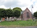
Saint-Mathurin Church
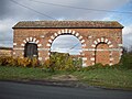
Remains of the manor house


Web links
Commons : Les Hogues - collection of images, videos and audio files