Muids
| Muids | ||
|---|---|---|

|
|
|
| region | Normandy | |
| Department | Your | |
| Arrondissement | Les Andelys | |
| Canton | Les Andelys | |
| Community association | Its Normandy agglomeration | |
| Coordinates | 49 ° 13 ′ N , 1 ° 17 ′ E | |
| height | 7-76 m | |
| surface | 15.22 km 2 | |
| Residents | 871 (January 1, 2017) | |
| Population density | 57 inhabitants / km 2 | |
| Post Code | 27430 | |
| INSEE code | 27422 | |
Muids is a French municipality with 871 inhabitants (as of January 1 2017) in the department of Eure in the region of Normandy . It belongs to the Arrondissement of Les Andelys and the Canton of Les Andelys . The inhabitants are called Muidsiens .
geography
Muids is located about 38 kilometers southeast of Rouen on the Seine . Neighboring municipalities of Muids are Herqueville in the north and north-west, Daubeuf-près-Vatteville in the north and north-east, La Roquette in the north-east, Les Trois Lacs in the south and east, Heudebouville in the south and south-west, Vironvay in the west and south-west and Andé in the west and north-west .
Population development
| year | 1962 | 1968 | 1975 | 1982 | 1990 | 1999 | 2006 | 2013 |
| Residents | 539 | 574 | 597 | 733 | 795 | 828 | 878 | 851 |
| Source: Cassini and INSEE | ||||||||
Attractions
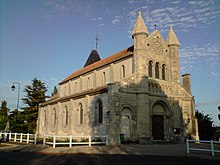
- 11th century church of Saint-Hilaire, a historic monument since 2009
- 17th century watermill, Monument historique since 2006
- 18th century mansion of Le Bout-de-la-Ville
- 17th century castle
Web links
Commons : Muids - collection of images, videos and audio files

