
Port Mort
| Port Mort | ||
|---|---|---|

|
|
|
| region | Normandy | |
| Department | Your | |
| Arrondissement | Les Andelys | |
| Canton | Les Andelys | |
| Community association | Its Normandy agglomeration | |
| Coordinates | 49 ° 10 ′ N , 1 ° 25 ′ E | |
| height | 8-138 m | |
| surface | 12.17 km 2 | |
| Residents | 931 (January 1, 2017) | |
| Population density | 76 inhabitants / km 2 | |
| Post Code | 27940 | |
| INSEE code | 27473 | |
| Website | http://www.port-mort.com/ | |
 Town Hall (Mairie) of Port-Mort |
||

Port-Mort is a French municipality with 931 inhabitants (as of January 1 2017) in the department of Eure in the region of Normandy . It belongs to the Arrondissement of Les Andelys and the Canton of Les Andelys . The inhabitants are called Pormortais .
geography
Port-Mort is about 50 kilometers southeast of Rouen on the Seine . Neighboring municipalities of Port-Mort are Bouafles in the north, Hennezis in the north-east, Notre-Dame-d'Isle in the south and east, Saint-Pierre-la-Garenne in the south and south-west, Gaillon in the west and Courcelles-sur-Seine in the north-west.
Population development
| year | 1962 | 1968 | 1975 | 1982 | 1990 | 1999 | 2006 | 2013 |
| Residents | 441 | 431 | 563 | 672 | 839 | 820 | 1.008 | 937 |
| Source: Cassini and INSEE | ||||||||
Attractions
- Menhir Gravier de Gargantua (Port-Mort) since 1923 Monument historique
- Saint-Pierre church
- Castle ( Château-Neuf )
- Castle from the 17th / 18th centuries century
- Grave monument of Saint Ethbin

Menhir of Port-Mort

Saint-Pierre church
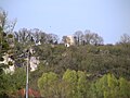
Castle
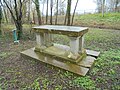
Grave monument of Saint Ethbin


Web links
Commons : Port-Mort - collection of pictures, videos and audio files