
Vascœuil
| Vascœuil | ||
|---|---|---|
|
||
| region | Normandy | |
| Department | Your | |
| Arrondissement | Les Andelys | |
| Canton | Romilly-sur-Andelle | |
| Community association | Lyons Andelle | |
| Coordinates | 49 ° 27 ' N , 1 ° 23' E | |
| height | 52-171 m | |
| surface | 7.39 km 2 | |
| Residents | 355 (January 1, 2017) | |
| Population density | 48 inhabitants / km 2 | |
| Post Code | 27910 | |
| INSEE code | 27672 | |
 Town hall (Mairie) of Vascœuil |
||

Vascoeuil is a French municipality with 355 inhabitants (at January 1, 2017) in the department of Eure in the region Normandy (before 2016 Haute-Normandie ). It belongs to the arrondissement of Les Andelys and the canton of Romilly-sur-Andelle (until 2015 Lyons-la-Forêt ). The inhabitants are called Vascœuillais .
geography
Vascœuil is about 25 kilometers east of Rouen . Vascœuil is surrounded by the neighboring communities of Saint-Denis-le-Thiboult in the north and west, Elbeuf-sur-Andelle in the north, Croisy-sur-Andelle in the north and northeast, Le Tronquay in the east, Les Hogues in the south and southeast and Perruel in the South and northwest.
Population development
| year | 1962 | 1968 | 1975 | 1982 | 1990 | 1999 | 2006 | 2013 |
| Residents | 257 | 278 | 271 | 317 | 344 | 339 | 339 | 346 |
| Source: Cassini and INSEE | ||||||||
Attractions
- Saint-Martial church from the 11th century, remodeled in the 17th century
- Castle with the Jules Michelet Museum, Monument historique
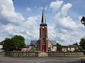
Saint-Martial church

lock


Web links
Commons : Vascœuil - collection of images, videos and audio files