
Herqueville (yours)
| Herqueville | ||
|---|---|---|
.svg)
|
|
|
| region | Normandy | |
| Department | Your | |
| Arrondissement | Les Andelys | |
| Canton | Val-de-Reuil | |
| Community association | His-yours | |
| Coordinates | 49 ° 15 ′ N , 1 ° 16 ′ E | |
| height | 6–65 m | |
| surface | 3.76 km 2 | |
| Residents | 134 (January 1, 2017) | |
| Population density | 36 inhabitants / km 2 | |
| Post Code | 27430 | |
| INSEE code | 27330 | |
 Town Hall (Mairie) of Herqueville |
||

Herqueville is a French municipality with 134 inhabitants (as of January 1 2017) in the department of Eure in the region of Normandy . It belongs to the arrondissement of Les Andelys and the canton of Val-de-Reuil . The inhabitants are called Herquevillais .
geography
Herqueville is located about 25 kilometers south-southeast of Rouen on the Seine . Herqueville is surrounded by the neighboring communities of Porte-de-Seine in the north and west, Connelles in the north, Daubeuf-près-Vatteville in the east and north-east, Muids in the south and east and Andé in the south-west.
Population development
| year | 1962 | 1968 | 1975 | 1982 | 1990 | 1999 | 2006 | 2013 |
| Residents | 188 | 284 | 293 | 187 | 182 | 155 | 152 | 150 |
| Source: Cassini and INSEE | ||||||||
Attractions
- Saint-Germain church from the 15th century, alterations from the 17th century
- Renault Castle

Saint Germain Church
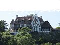
Renault Castle
_2.jpg)

Web links
Commons : Herqueville - collection of images, videos and audio files