
San Siro (Lombardy)
| San Siro | ||
|---|---|---|

|
|
|
| Country | Italy | |
| region | Lombardy | |
| province | Como (CO) | |
| Coordinates | 46 ° 4 ′ N , 9 ° 16 ′ E | |
| height | 216 m slm | |
| surface | 18 km² | |
| Residents | 1,752 (Dec. 31, 2019) | |
| Population density | 97 inhabitants / km² | |
| Post Code | 22010 | |
| prefix | 0344 | |
| ISTAT number | 013248 | |
| Website | San Siro | |

.svg)

San Siro is an Italian municipality on the west bank of Lake Como (Lago di Como) in the province of Como (Provincia di Como).
geography
The municipality is located at the foot of Monte Bregagno (2,107 m above sea level) and includes the fractions: Acquaseria , Camnasco , Carcente , Gallio , Lancio , La Torre , Santa Maria Rezzonico , Roncate , San Martino and Treccione . The neighboring municipalities are: Cremia , Plesio , Menaggio , Bellano and Perledo .
history
The place was created in 2003 from the union of the places Acquaseria and Santa Maria Rezzonico. The name was chosen by a vote among the residents of the places. San Siro consists of a collection of small villages and hamlets that extend from the lakeshore up to 1,100 m above sea level. M. extend.
Today, San Siro has a population of 1752 (as of December 31, 2019). In the summer months, the number of inhabitants doubles due to the holiday homes that are often used for tourism.
Population development
Data from ISTAT

Attractions
- The parish church of Santa Maria (XV century) with paintings by Michelangelo Carminati and Sigismondo de Magistris was built between 1464 and 1474 for the Dominican convent and dedicated to the Virgin Mary. The church, located directly on the shores of the lake, was built on the remains of a church dedicated to the Madonna, which was originally a pagan temple. From the facade, the marble church portal with engraved symbols from the Passion is particularly interesting.

The interior of the church impresses with the numerous frescoes that were created in the 16th century. on lombardiabeniculturali.it
- Church of San Martino (17th century) in the district of Carcente
- Castle ruins near Santa Maria
- Villa La Gaeta, architect: Gino Coppedè on lombardiabeniculturali.it
- The castle in the Rezzonico district was built in 1363 by the Counts Della Torre on the remains of an older fortification. The castle, which is surrounded by a crenellated wall, encloses an area of over 2,000 m² that extends to the lake shore and, in addition to the central tower, which is also crenellated, also houses residential buildings. The castle is privately owned and cannot be visited. There is a small rocky beach below the castle.
Roman fortress
In the immediate vicinity of the church of Santa Maria Assunta in a northerly direction, with walls up to 6 m high, there are the remains of an extensive Roman fortress, which is unique in terms of size in the province of Como. The original area of the building extended to the nearby church of Santa Maria Assunta. The exact meaning of the building has not been finally clarified. However, it was very likely a fortification to control trade on the lake and the old trade route Antica Strada Regina.
photos
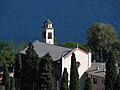
Santa Maria Assunta Church in San Siro on the shores of Lake Como.

Frescoes of the Church of Santa Maria Assunta
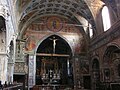
Frescoes in the Church of Santa Maria Assunta in San Siro on Lake Como

Parish Church of Santa Maria Assunta in the fraction Santa Maria Rezzonico
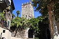
Rezzonico Castle

Roman fortress of San Siro


literature
- Luigi Mario Belloni, Renato Besana, Oleg Zastrow: Castelli, basiliche e ville. Tesori architettonici lariani nel tempo. Como 1991.
- Gilda Grigioni della Torre: Ville storiche sul Lago di Como. Ivrea 2001.
Web links
- San Siro on lombardiabeniculturali.it/architetture/
- San Siro on tuttitalia.it/
- San Siro on comuni-italiani.it/
- San Siro on lombardia.indettaglio.it/
Individual evidence
- ↑ Statistiche demografiche ISTAT. Monthly population statistics of the Istituto Nazionale di Statistica , as of December 31 of 2019.
- ↑ Church of Santa Maria (photo)
- ↑ Church of San Martino (photo)
- ↑ Villa La Gaeta (photo)

Albavilla | Albese con Cassano | Albiolo | Alserio | Alta Valle Intelvi | Alzate Brianza | Anzano del Parco | Appiano Gentile | Argegno | Arosio | Asso | Barni | Bellagio | Bene Lario | Beregazzo con Figliaro | Binago | Bizzarone | Blessagno | Blevio | Bregnano | Brenna | Brienno | Brunate | Bulgarograsso | Cabiate | Cadorago | Caglio | Campione d'Italia | Cantù | Canzo | Capiago Intimiano | Carate Urio | Carbonates | Carimate | Carlazzo | Carugo | Caslino d'Erba | Casnate con Bernate | Cassina Rizzardi | Castelmarte | Castelnuovo Bozzente | Cavargna | Centro Valle Intelvi | Cerano d'Intelvi | Cermenate | Cernobbio | Cirimido | Claino con Osteno | Colonno | Colverde | Como | Corrido | Cremia | Cucciago | Cusino | Dizzasco | Domaso | Dongo | Dosso del Liro | Erba | Eupilio | Faggeto Lario | Faloppio | Fenegrò | Figino Serenza | Fino Mornasco | Garzeno | Gera Lario | Grandad | Grandola ed Uniti | Gravedona ed Uniti | Griante | Guanzate | Inverigo
Laglio | Laino | Lambrugo | Lanzo d'Intelvi | Lasnigo | Lezzeno | Limido Comasco | Lipomo | Livo | Locate Varesino | Lomazzo | Longone al Segrino | Luisago | Lurago Marinone | Lurago d'Erba | Lurate Caccivio | Magreglio | Mariano Comense | Maslianico | Menaggio | Merone | Moltrasio | Monguzzo | Montano Lucino | Montemezzo | Montorfano | Mozzate | Musso | Nesso | Novedrate | Olgiate Comasco | Oltrona di San Mamette | Orsenigo | Peglio | Pellio Intelvi | Pianello del Lario | Pigra | Plesio | Pognana Lario | Ponna | Ponte Lambro | Porlezza | Proserpio | Pusiano | Ramponio Verna | Rezzago | Rodero | Ronago | Rovellasca | Rovello Porro | Sala Comacina | San Bartolomeo Val Cavargna | San Fermo della Battaglia | San Nazzaro Val Cavargna | San Siro | Schignano | Senna Comasco | Solbiate con Cagno | Sorico | Sormano | Stazzona | Tavernerio | Torno | Tremezzina | Trezzone | Turate | Uggiate Trevano | Val Rezzo | Valbrona | Valmorea | Valsolda | Veleso | Veniano | Vercana | Vertemate con Minoprio | Villa Guardia | Zelbio