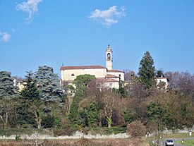
Orsenigo (Lombardy)
| Orsenigo | ||
|---|---|---|

|
|
|
| Country | Italy | |
| region | Lombardy | |
| province | Como (CO) | |
| Local name | Ursenìg | |
| Coordinates | 45 ° 47 ' N , 9 ° 11' E | |
| height | 390 m slm | |
| surface | 4.5 km² | |
| Residents | 2,703 (Dec. 31, 2019) | |
| Population density | 601 inhabitants / km² | |
| Post Code | 22030 | |
| prefix | 031 | |
| ISTAT number | 013170 | |
| Popular name | Orsenighesi | |
| Website | Orsenigo | |

Orsenigo municipality in the province of Como
Orsenigo is a northern Italian municipality ( comune ) with 2703 inhabitants (as of December 31, 2019) in the province of Como in Lombardy . The municipality is located about 9 kilometers east-southeast of Como .
traffic
The former state road 342 runs through the municipality from Bergamo to Varese . On the border to the neighboring municipality of Alzate Brianza is the Aeroporto di Alzate Brianza , which is primarily used as a glider airfield.
Attractions
- Parish Church of San Martino (1894)
- Oratory Divina Maternità di Maria e di San Giovanni Battista (18th century)
- Villa del Soldo (20th century)
- Archaeological finds (4th – 3rd century BC) near Soldo
Personalities
- Aldo Pifferi (1938), racing cyclist
- Simone d'Orsenigo , (* 14th century), architect of the Milan Cathedral
- Paolo Pedretti (1906–1983), racing cyclist, Olympic champion 1932 in group track cycling
literature
- Orsenigo on tuttitalia.it/lombardia
Web links
Commons : Orsenigo - collection of images, videos and audio files
Individual evidence
- ↑ Statistiche demografiche ISTAT. Monthly population statistics of the Istituto Nazionale di Statistica , as of December 31 of 2019.
- ↑ Parish Church of San Martino (photo)
- ↑ Oratorio Divina Maternità di Maria e di San Giovanni Battista (photo)
- ↑ Villa del Soldo (photo)


