
Bopfingen
| coat of arms | Germany map | |
|---|---|---|

|
Coordinates: 48 ° 51 ' N , 10 ° 21' E |
|
| Basic data | ||
| State : | Baden-Württemberg | |
| Administrative region : | Stuttgart | |
| County : | Ostalbkreis | |
| Height : | 468 m above sea level NHN | |
| Area : | 76.98 km 2 | |
| Residents: | 11,727 (Dec. 31, 2018) | |
| Population density : | 152 inhabitants per km 2 | |
| Postal code : | 73441 | |
| Area code : | 07362 | |
| License plate : | AA, GD | |
| Community key : | 08 1 36 010 | |
| City structure: | 9 districts | |
City administration address : |
Marktplatz 1 73441 Bopfingen |
|
| Website : | ||
| Mayor : | Gunter Bühler ( CDU ) | |
| Location of the city of Bopfingen in the Ostalb district | ||
  |
||


Bopfingen is a city in the Ostalbkreis in the far east of Baden-Württemberg and a former imperial city .
geography
Geographical location
Bopfingen is located on the northern edge of the Härtsfeld and on the western edge of the Nördlinger Ries in the valley of the Eger , a tributary of the Wörnitz , and in the area of the Geopark Ries .
In the north of the city is the 668 meter high Ipf . The Schloßberg (579 meters) with the Flochberg ruins is south of the city. Other prominent elevations are the Sandberg (651 meters) and Baldern Castle (628 meters). The highest point is in the Hohe Brach forest near Bopfingen-Unterriffingen (669 meters), Bopfingen-Trochtelfingen on the edge of the Ries is 448 meters above sea level.
Neighboring communities
The city borders in the north on Unterschneidheim , in the northeast on Kirchheim am Ries , in the east on Riesbürg and the Bavarian city of Nördlingen , in the south on the city of Neresheim , in the west on the city of Lauchheim and the district town of Aalen .
City structure
Bopfingen, with the formerly independent communities Aufhausen, Baldern, Flochberg , Kerkingen, Oberdorf am Ipf, Schloßberg , Trochtelfingen and Unterriffingen, includes 32 villages, hamlets, farms and houses in addition to the core town of Bopfingen. Over half of the population lives in the suburbs.
Former suburb affiliation
The formerly independent municipality Aufhausen includes the village of Aufhausen, the hamlets of Bayermühle and Michelfeld and the houses Schlägweidmühle and Walkmühle as well as the abandoned villages of Hof Illenberg and Untere Schlägweidmühle. The former municipality of Baldern included the village of Baldern, the hamlet of Zimmerstetten, Baldern Castle , the Blankenhöfe homestead, the forester's house and multi-storey car park as well as the abandoned village of Wigermühle. The town of Bopfingen in the 1969 territorial status included the town of Bopfingen, the hamlet of Hohenberg, the Kalkofen homestead and the Holzmühle farm as well as the abandoned villages of Hahnenberg, Wendenhof, Hahnenmühle and Wiesmühle. The former municipality of Flochberg included the village of Flochberg, the hamlets of Dorfen and Härtsfeldhausen and the Heidmühle house. The village of Kerkingen and the hamlets of Edelmühle, Itzlingen and Meisterstall belonged to the former municipality of Kerkingen. The former municipality of Oberdorf am Ipf included the village of Oberdorf am Ipf and the Nagelmühle and Steinmühle farms, as well as the abandoned village of Mugenhofen. The village of Schloßberg belonged to the former municipality of Schloßberg. The village of Trochtelfingen and the farms Obere Röhrbachmühle and Untere Röhrbachmühle belonged to the former municipality of Trochtelfingen. The village of Unterriffingen, the hamlet of Oberriffingen and the Ungnad homestead belonged to the former municipality of Unterriffingen.
Division of space

(based on data from the State Statistical Office , as of 2014).
history
antiquity
Fortifications from the late Bronze and early Iron Ages are located on the Ipf . The most recent sites such as the sanctuary in Bugfeld near Osterholz, excavated in 2004, have shown that the Ipf belongs to the series of early Celtic princely seats such as the Heuneburg or Mont Lassois .
In Roman times, the Roman fort Oberdorf (Opie) was located on the area of today's upper village . Opie seems to be a prehistoric name for the Ipf. Archaeological findings suggest that there was a brickworks in the district of Baldern in the Great Heide corridor during Roman times.
middle Ages
The place itself emerged from an Alemannic settlement founded around 500 , which was elevated to a city in 1153.
1188 "burgus Bebphingin" (fortified city of Bopfingen) was mentioned in a contract between Emperor Friedrich I Barbarossa and King Alfons VIII of Castile , in which the marriage between Friedrich's son Konrad and Alfons' daughter Berengaria was agreed. Bopfingen was part of the bride's morning gift along with 29 other Staufer goods . However, this marriage was never put into practice.
Time as an imperial city
During the decline of the Staufer, Bopfingen became an imperial city after 1240 . In 1488 the town joined the Swabian Federation to defend itself against the threat from the county of Oettingen . Because of the constant competition with the Counts of Oettingen, Bopfingen was unable to build up any larger territory. As an imperial city, Bopfingen was therefore of little importance and only occupied the 37th and last position on the Swabian bank in the imperial city council .
In 1545 and 1546 Bopfingen carried out the Reformation . As a punishment, Emperor Charles V had Bopfingen plundered by Spanish troops in the Schmalkaldic War in 1546 .
Towards the end of August 1634, Bopfingen was plundered and largely destroyed by the Croatian advance troops of the imperial army under General Isolani . The imperial troops were approaching Nördlingen, where the battle of Nördlingen took place in early September . The imperial troops were followed by two Swedish armies, who set up a common camp on the Breitwang near Bopfingen, from where they attacked the imperial-Spanish siege troops of Nördlingen.
In 1802 Bopfingen lost its imperial immediacy and came to Bavaria.
Württemberg time
In 1810, Bopfingen became part of the Kingdom of Württemberg through the border treaty with Bavaria . There it belonged to the Oberamt Neresheim . On July 10, 1811, King Friedrich von Württemberg visited the newly won city. The Ipfmesse commemorates this event to this day .
The administrative reform during the Nazi era in Württemberg led to membership in the Aalen district in 1938 .
During the November pogrom of 1938 , SA men set fire to the Synagogue at Lange Strasse 15, which, however, was extinguished by courageous neighbors. After the eviction and deportation of the Jewish inhabitants, the synagogue served as a gymnasium from 1940, then as a prisoner of war camp , from 1950 as a Catholic church and then as a storage room. In the Jewish cemetery on Karksteinstrasse, memorial plaques with the names of the victims of the Shoah remembered . There is also a Jewish cemetery in Aufhausen (last burial in 1940, 363 tombstones have been preserved).
During the Second World War, on the night of October 14-15, 1941, English planes probably bombed the place. In the same year, the Jewish residents of Bopfingen were brought to the Killesberg camp in Stuttgart in four deportation trains . On April 1, 1945 they ordered the construction of anti-tank barriers. Nevertheless, the city was handed over to the Americans on April 22nd.
post war period
Since Bopfingen had become part of the American zone of occupation after the Second World War , the city had belonged to the newly founded state of Württemberg-Baden since 1945 , which was merged into the current state of Baden-Württemberg in 1952.
In 1946 Bopfingen had 2800 inhabitants; In 1968 there were already 4,100.
Through the district reform in 1973 Bopfingen came into the newly founded Ostalbkreis .
Incorporations
- January 1, 1970: Flochberg
- January 1st, 1971: Schlossberg
- January 1, 1972: Kerkingen
- April 1, 1972: Trochtelfingen
- October 1, 1973: Baldern, Oberdorf am Ipf
- January 1, 1975: Aufhausen, Unterriffingen
Coats of arms of the districts

Flochberg

Schlossberg

Kerkingen

Trochtelfingen

Baldern

Oberdorf

Aufhausen

Unterriffingen


.png)

.png)


Religions
The former imperial city of Bopfingen was purely Protestant . The mayor and the city council signed the Lutheran concord formula of 1577. As a result of immigration in the 19th and 20th centuries and the incorporation of the predominantly Catholic neighboring villages, the population of today's city of Bopfingen is predominantly Catholic . There are seven Catholic parishes (Aufhausen, Baldern, Bopfingen, Flochberg, Kerkingen with the branch church Itzlingen, Oberdorf am Ipf, Unterriffingen) that belong to the Deanery Ostalb , and three Protestant parishes ( Bopfingen , Oberdorf am Ipf and Trochtelfingen ) as well as one parish each the New Apostolic Church , Jehovah's Witnesses and the Free Evangelical Congregation .
politics
Municipal council
The council Bopfingens there since the last municipal election held on 26 May 2019 of 28 members whose term of office is five years. The seats are distributed among the individual parties and groups as follows:
| fraction | Strength | change |
|---|---|---|
| CDU | 13 seats | ± 0 |
| SPD | 7 seats | ± 0 |
| Free voters | 8 seats | + 2 |

mayor
Gunter Bühler has been the mayor of Bopfingen since February 2006. Bühler is an economic geographer and previously worked in the field of economic and structural policy in Bavaria.
Former mayors were Bernhard Rapp (1998–2006), Erich Göttlicher (1973–1998), Hans Ellinger (1936–1945, 1954–1973), Paul Merz (1945–1947), Eugen Enslin (1903–1936), Adolf Bergmüller ( 1900–1903), Wilhelm Dörr (1877–1899) and Wilhelm Haas (1840–1876).
Administrative community
The city is the seat of the agreed administrative community of the city of Bopfingen with the communities of Kirchheim am Ries and Riesbürg.
badges and flags
The blazon of the coat of arms reads: "The black imperial eagle in gold, covered with a breast shield split by red and blue, inside a golden clip ( kettle ring )." The oldest detectable seal dates from 1279 and only contained the imperial eagle . The split shield with the clip, which is often referred to as a loop or eyelet, was shown for the first time in 1552 as a sign. It has been depicted as a breastplate on the eagle since the 17th century. The coat of arms was last confirmed in its current form and tinging in 1955.
The city colors of Bopfingen are red and blue.
Town twinning
The city maintains partnership relations with the French Beaumont in the Auvergne-Rhône-Alpes region (since 1989) and with the Italian Russi near Ravenna (since 1996) as part of a three-way partnership.
Economy and Infrastructure
traffic
Trains of the Riesbahn ( Aalen - Donauwörth ) stop in Aufhausen, Bopfingen and Trochtelfingen . The federal road 29 ( Waiblingen - Nördlingen ) connects Bopfingen with the national road network.
Bopfingen is located on the Swabian Alb Cycle Path , a long-distance cycle path that leads from Lake Constance to Nördlingen across the entire Swabian Alb.
Established businesses
The company Ladenburger GmbH, based in Bopfingen-Aufhausen, claims to be the second largest woodworks in Baden-Württemberg. The headquarters of the furniture trading company Möbel Mahler was located in Bopfingen. The mechanical engineering company VAF GmbH develops and produces special machines for well-known automobile manufacturers in Bopfingen.
Educational institutions
With the Ostalb-Gymnasium , a Realschule , a Hauptschule with Werkrealschule and three primary schools , Bopfingen has the full range of the regular school system. There is also the Stauferschule, a special educational and advisory center with a focus on learning (SBBZ-L).
There is also the Bopfingen Municipal Music School . Six Roman Catholic , two Protestant and five municipal kindergartens complete the educational offer.
media
Daily newspapers with local parts in Bopfingen are the Ipf and Jagst newspaper / Aalener Nachrichten , based in Ellwangen and Aalen, and the Schwäbische Post , based in Aalen.
Culture and sights
Bopfingen is located on the Swabian Alb North Edge Path or Albsteig, a hiking trail that leads past many sights.
Buildings
- City church St. Blasius with the late medieval winged altar (1472) by Friedrich Herlin .
- Old Town Hall, half-timbered building built by Wolfgang Waldberger from 1585–1586 with a striking pillory.
- Baroque residential palace Baldern in the Baldern suburb with a large collection of weapons.
- The Stolch'sche Schloss in Trochtelfingen
- The baroque pilgrimage church of the Visitation of the Virgin Mary (Our Lady of the Rye Field) in Flochberg was built between 1741 and 1746.
- Transmitter Bopfingen , SWR transmission tower for VHF and TV (until 1993 also for medium wave)
- Ruins of Flochberg Castle in the Schloßberg district
- Ruins of Schenkenstein Castle in the Aufhausen district
- Pilgrimage church of St. Ottilia in the district of Kerkingen
- Synagogue in the Oberdorf district (destroyed in 1938, now used as a museum)
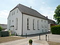
The synagogue in the Oberdorf district

The synagogue, entrance

Pilgrimage church Flochberg

The Stolch's Castle in Trochtelfingen

St. George's Church in Oberdorf am Ipf

Baldern Castle

Staufer column (2014)


Museums
- The history of Bopfingen and its surroundings is shown in the historic Seelhaus from 1505.
- The memorial and meeting place in the former synagogue in Bopfingen-Oberdorf deals with the history of what was once the largest Jewish community in East Württemberg.
- The Trochtelfingen Heimatstube is a museum of rural technology and culture.
- The historic herb chamber from 1720 can be visited in the Reichsstadtapotheke.
Monuments
- On October 10, 2014, a Staufer stele was inaugurated on the square redesigned for this occasion between the town church St. Blasius and the town wall in the Vorderen Pfarrgasse , reminding of Bopfingen's role in the Staufer era and the battle of Flochberg.
Regular events
The Ipfmesse is an annual folk festival that began in 1811.
Personalities
sons and daughters of the town
- Georg Marcell Haack (1652–1719), painter
- Johann Daniel Herrnschmidt (1675–1723), Protestant theologian and German hymn poet
- Georg Ludwig Herrnschmidt (1712–1779), Protestant theologian
- Wilhelm Meyder (1841–1927), born in Oberdorf am Ipf, mayor and member of the state parliament
- Albert Schieber (1875–1946), architect
- Otto Ferdinand Rettenmaier (1902–1988), professor at the Schwäbisch Gmünd University of Education
- Richard Schieber (unknown – 1994), businessman and founder of the Richard Schieber Foundation with endowment capital of DM 2 million
- Josef Vogel (1906–1997), Roman Catholic prelate
- Marianne Fuchs (1908–2010), teacher, therapist and author
- Johann Legner (1954–2015), journalist and book author
- Heinrich Hiesinger (* 1960), Industry Manager, Chairman of the Executive Board of ThyssenKrupp AG since January 21, 2011
Other personalities
- Daniel Schwarz (1880–1969), accountant, conservationist and geologist, lived in Oberdorf.
- Chris Mike (* 1961), guitarist, music and film producer, lived in Bopfingen from 1966 to 1972.
- Hermann Kroner (1870–1930), rabbi in Bopfingen-Oberdorf, numerous studies on Moses Maimonides
- Georg Sternbacher (1933–1995), painter, lived in Oberriffingen from 1970 until his death in 1995.
Individual evidence
- ↑ State Statistical Office Baden-Württemberg - Population by nationality and gender on December 31, 2018 (CSV file) ( help on this ).
- ↑ Bopfingen in numbers. City of Bopfingen, accessed on March 25, 2014 (German).
- ^ The state of Baden-Württemberg. Official description by district and municipality. Volume IV: Administrative region of Stuttgart, regional associations of Franconia and East Württemberg. Kohlhammer, Stuttgart 1980, ISBN 3-17-005708-1 , pp. 683-691.
- ↑ State Statistical Office, area since 1988 according to actual use .
- ^ Dieter Planck: The Romans in Baden-Württemberg . Theiss, Stuttgart 2005, ISBN 3-8062-1555-3 , p. 48f.
- ↑ Ulrich Brandl, Emmi Federhofer: Sound + Technology. Roman bricks. Theiss, Stuttgart 2010, ISBN 978-3-8062-2403-0 ( publications of the Limes Museum Aalen. No. 61).
- ^ Peter Koblank: Treaty of Seligenstadt 1188 on stauferstelen.net. Retrieved April 7, 2017.
- ↑ Ludwig Weiland, Jakob Schwalm, Margarete Kühn: Monumenta Germaniae historica, Vol. 3, Inde from a. MCCLXXIII. usque ad a. MCCXCVIII., Ed. Iacobus Schwalm, Hannoverae, 1904-1906.
- ↑ Peter Engerisser, Pavel Hrncirik: Nördlingen 1634. The battle near Nördlingen, turning point of the Thirty Years War . Späthling, Weißenstadt 2009, ISBN 978-3-926621-78-8 , pp. 83f., 97f.
- ↑ Memorial sites for the victims of National Socialism. A documentation, Vol. I, Bonn 1995, ISBN 3-89331-208-0 , p. 27.
- ↑ http://bopfingen.de/,Lde,(anker96084)/94394.html#anker96084_1933 History of Bopfingen
- ↑ a b c Federal Statistical Office (ed.): Historical municipality directory for the Federal Republic of Germany. Name, border and key number changes in municipalities, counties and administrative districts from May 27, 1970 to December 31, 1982 . W. Kohlhammer, Stuttgart / Mainz 1983, ISBN 3-17-003263-1 , p. 445 .
- ↑ a b Federal Statistical Office (ed.): Historical municipality register for the Federal Republic of Germany. Name, border and key number changes in municipalities, counties and administrative districts from May 27, 1970 to December 31, 1982 . W. Kohlhammer, Stuttgart / Mainz 1983, ISBN 3-17-003263-1 , p. 471 .
- ↑ Senta Herkle: Bopfingen. In: Württemberg Church History online.
- ↑ See BSLK , p. 765; see. P. 17.
- ↑ Archive link ( Memento of the original from November 3, 2010 in the Internet Archive ) Info: The archive link was automatically inserted and not yet checked. Please check the original and archive link according to the instructions and then remove this notice.
- ↑ Municipal Council Bopfingen 2019, preliminary final result , accessed on December 12, 2019
- ↑ Organization chart. Retrieved November 28, 2019 .
- ↑ Klemens Stadler: Deutsche Wappen, Volume 8. The municipal arms of the federal state of Baden-Württemberg. Angelsachsen-Verlag, Bremen 1971, p. 27.
- ↑ cf. Bodo Cichy: God's ballrooms - problem children of monument preservation. Securing, repairing and renewing baroque church buildings in the districts of Ostalb and Heidenheim. In: Denkmalpflege in Baden-Württemberg , 3rd year 1974, issue 4, pp. 2–25 ( PDF ( Memento of the original dated December 16, 2013 in the Internet Archive ) Info: The archive link was inserted automatically and has not yet been checked. Please check the original and archive link according to the instructions and then remove this note. )
- ↑ Peter Koblank: Precision work with a 35-ton truck. Spectacular structure of a Staufer column. on stauferstelen.net. Retrieved October 11, 2014.
literature
- C. Deffner: The Buchberg near Bopfingen . In: Annual notebooks of the Association for Patriotic Natural History in Württemberg , Volume 26, Stuttgart 1870.
Web links
- The Battle of Nördlingen / The Swedes on the Breitwang
- Internet presence of the city of Bopfingen
- Virtual 360 ° panoramic view of Bopfingen with Ipf and Ries from the Flochberg ruins (alb360.de)

Basking | Abtsgmünd | Adelmannsfelden | Bartholomä | Böbingen an der Rems | Bopfingen | Durlangen | Ellenberg | Ellwangen (Jagst) | Eschach | Essingen | Göggingen | Gschwend | Heubach | Hypocrites | Hüttlingen | Iggingen | Jagstzell | Kirchheim am Ries | Lauchheim | Leinzell | Lorch | Mögglingen | Mutlangen | Neresheim | Newbie | Obergröningen | Oberkochen | Rainau | Riesbürg | Rosenberg | Ruppertshofen | Schechingen | Schwäbisch Gmünd | Spraitbach | Stödtlen | Panel red | Tannhausen | Unterschneidheim | Waldstetten | Westhausen | Words