
Untergruppenbach
| coat of arms | Germany map | |
|---|---|---|

|
Coordinates: 49 ° 5 ' N , 9 ° 16' E |
|
| Basic data | ||
| State : | Baden-Württemberg | |
| Administrative region : | Stuttgart | |
| County : | Heilbronn | |
| Local government association: | "Schozach-Bottwartal" | |
| Height : | 254 m above sea level NHN | |
| Area : | 27.27 km 2 | |
| Residents: | 8304 (December 31, 2018) | |
| Population density : | 305 inhabitants per km 2 | |
| Postal code : | 74199 | |
| Primaries : | 07131, 07130 | |
| License plate : | HN | |
| Community key : | 08 1 25 098 | |
| LOCODE : | DE UPP | |
| NUTS : | DE118 | |
| Community structure: | 6 districts | |
| Address of the municipal administration: |
Kirchstrasse 2 74199 Untergruppenbach |
|
| Website : | ||
| Mayor : | Andreas Vierling | |
| Location of the community Untergruppenbach in the district of Heilbronn | ||
  |
||


Untergruppenbach is a municipality in the district of Heilbronn , Baden-Württemberg, about 7 km southeast of Heilbronn . It belongs to the Heilbronn-Franconia region (until May 20, 2003 Franconia region ) and the peripheral zone of the European metropolitan region of Stuttgart .
geography
Geographical location
Untergruppenbach is located in the south of the district of Heilbronn, about 6 km southeast of the immediately neighboring city of Heilbronn in the valley of the Gruppenbach and at the foot of the wooded Löwensteiner Mountains , where these merge to the south into the hilly arable landscape east of the central Neckar valley. A significant part of the area of the municipality, which drains almost exclusively to the south to the Schozach , is also in the western branch of the Löwensteiner Mountains, which means that it has a share in the natural areas of the Swabian-Franconian Forest Mountains and Neckar Basin .
Neighboring communities
Neighboring cities and communities in Untergruppenbach are ( clockwise , starting in the northwest): Heilbronn ( city district ), Lehrensteinsfeld , Löwenstein , Lauffen am Neckar (exclave Stadtwald Etzlensendung), Beilstein (exclave Farnersberg ), Abstatt , Ilsfeld , Talheim and Flein (all districts Heilbronn). Together with Abstatt, Beilstein and Ilsfeld, Untergruppenbach forms the community administration association Schozach-Bottwartal, based in Ilsfeld.
Community structure
The community Untergruppenbach consists of Untergruppenbach itself and Unterheinriet. The hamlets of Donnbronn and Obergruppenbach as well as Stettenfels Castle and Courtyard belong to Untergruppenbach, and the hamlets of Oberheinriet and Vorhof belong to Unterheinriet. The abandoned , i.e. no longer existing, towns of Besenhausen, Espenweiler, Gerhausen and Schwengelhausen were on the Unterheinriet mark, as was Heinriet Castle, which no longer existed.
The community of Untergruppenbach (2007) has around 7500 inhabitants, of which 3900 live in the Untergruppenbach district, 850 in Donnbronn, 470 in Obergruppenbach, 1700 in Unterheinriet, 500 in Oberheinriet and 140 in Vorhof.
Division of space

According to data from the State Statistical Office , as of 2014.
A more detailed breakdown for 2001
Even then, the municipal area covered 27.27 km². This area was divided as follows:
- 3.79 km² settlement and traffic area, thereof
- 1.90 km² of building and open space
- 1.78 km² traffic area
- 11.19 km² of agricultural area, thereof
- 7.67 km² of arable land
- 2.95 km² of meadows
- 0.98 km² of vineyards
- 12.13 km² of forest
- 0.09 km² water surface
- 0.07 km² Other types of use
history
Untergruppenbach


Below the Stettenfels there was probably the first settlement in the 6th century. The first documentary mention under the name Gruppenbach took place in 1109 in a deed of donation from Conrad von Merlenheim. The name "Groppenbach" referred to both the place and the stream that ran through it, which is now known as the Gruppenbach. Its name goes back to the freshwater fish bullhead , which once also fed a lake that dried up before 1600. In the High Middle Ages the community changed hands several times. In 1277, Count Palatine Ludwig II acquired the community before both the village and Stettenfels Castle were passed on to Burkard Sturmfeder in 1356 . The Sturmfeder operated the expansion of the castle from 1370. In 1481, Emperor Friedrich III. the establishment of a bathroom, a bakery and an open tavern in the village. In 1504 Duke Ulrich von Württemberg conquered the rule of Stettenfels on behalf of the emperor and then received it as a fief, which he passed on to his Hereditary Marshal Konrad Thumb von Neuburg in 1507. After an interlude in the hands of Wolf Philipp von Hirnheim , who became the owner in 1527 and carried out the Reformation in 1536 , the Fugger family owned the community from 1551 onwards . In the Thirty Years War in 1632 Joh. Nicodemi von Ahausen was enfeoffed by the Swedish King Gustav II Adolf with the rule of Stettenfels, but after Ahausen's death in the same year the old ownership was restored. In 1737 there was a dispute between the villagers and Count Anton Fugger, whereupon two citizens were shot. In 1747 Count Anton Sigmund Fugger sold the rule to Duke Carl Eugen of Württemberg .
After the founding of the Kingdom of Württemberg there was a new administrative reorganization at the beginning of the 19th century . Initially, Untergruppenbach belonged to the Beilstein Upper Office until 1810 , after its dissolution to the Heilbronn Upper Office until 1812, to the Besigheim Upper Office from 1812 , and then to the Heilbronn Upper Office from 1842 after many submissions and requests from the community. In 1829 the community bought the castle, but in 1852 it was sold again in private ownership. A post office was founded in 1893 and a new elementary school was built in 1905. In 1909 and 1911 a central water supply and connection to the electricity network were installed. Since the administrative reform in 1938 during the Nazi era in Württemberg , Untergruppenbach has belonged to the Heilbronn district . In the same year, with the construction of the Reichsautobahn from Heilbronn to Stuttgart (now part of the A 81 ) and the feeder road from Heilbronn, the landscape around the place changed considerably. In 1945 the place became part of the American zone of occupation and thus belonged to the newly founded state of Württemberg-Baden , which was incorporated into the current state of Baden-Württemberg in 1952. In 1953, the Gruppenbach was verdolt in place . In 1962 the community acquired the old Protestant rectory and converted it into the town hall the following year . In 1971 Untergruppenbach and Unterheinriet formed an administrative partnership. On January 1, 1974 Unterheinriet and its districts were incorporated.
On January 17, 1982 in Untergruppenbach, the Kosovar poet and dissident Jusuf Gervalla , who lived in exile with his family, was murdered by the Yugoslav secret service, presumably together with his brother and another opponent of the regime.
Unterheinriet


Unterheinriet was mentioned for the first time in 1139 with the naming of a helper de Hehenried in King Konrad's entourage . The place name goes back to the Lords of Hohenriet, whose Hohenriet Castle ( castle on the cleared height ) stood in the neighboring village of Vorhof ( courtyard in front of the castle ) and to whom only the field name Burgsel reminds us today. The lords of the castle are mentioned several times in the 12th and 13th centuries and bear the same coat of arms as the Hacken zu Hoheneck. In 1327 Konrad von Heinrieth acquired the castle and town of Neudenau from Konrad von Weinsberg . In 1330, Count Nicolaus von Löwenstein acquired half of the castle and village of Unterheinrieth. After numerous sales and mortgages, the Counts of Löwenstein acquired the entire estate in 1364. In the period that followed, the lords of Heinriet also sold all their foreign possessions, so that they were completely without possessions in 1456 before the last offspring, Philipp von Heinriet, died out in 1462. After the county of Löwenstein and thus Unterheinriet became part of Württemberg in 1504, the latter was separated from the county in 1510 and assigned to the Württemberg office of Beilstein. The Swabian Federation destroyed Hohenriet Castle in 1528 because it was the retreat of the farmer's leader Hans Thomas von Absberg , a colleague of Götz von Berlichingen .
After the founding of the Kingdom of Württemberg, Unterheinriet moved in 1807 from the Oberamt Beilstein to the Oberamt Weinsberg . The bridge over the Schozach was built in 1830, and a schoolhouse in 1874. A post office was opened in 1900, and in 1908 bus services began from Heilbronn via Flein, Untergruppenbach and Abstatt to Unterheinriet. After the dissolution of the Oberamt Weinsberg, the place came to the Oberamt Heilbronn in 1926 as part of an administrative reform of the People's State of Württemberg , which was converted into the Heilbronn district in 1938 . In 1927 the first community hall was built, which was one of the first community halls in Württemberg. Towards the end of the Second World War, 45% of Unterheinriet, 35% of Oberheinriet and 90% of the Vorhof was destroyed by American air raids. In 1945 the place became part of the American zone of occupation and thus belonged to the newly founded state of Württemberg-Baden , which was incorporated into the current state of Baden-Württemberg in 1952. After an administrative community with Untergruppenbach had existed since 1971, Unterheinriet and its districts were incorporated into Untergruppenbach on January 1, 1974.
Religions
Since Wolf Philipp von Hirnheim carried out the Reformation in 1536, Untergruppenbach has been predominantly evangelical. Although Ludwig Xaver Fugger tried to build a Catholic church in 1735, Duke Karl Alexander , Duke of Württemberg, had it demolished before completion. In Untergruppenbach and Unterheinriet there is a separate Protestant parish each. The Protestant parish Untergruppenbach belongs to the Heilbronn church district , the Unterheinriet Protestant parish belongs to the Weinsberg-Neuenstadt church district , both in the Evangelical Church in Württemberg .
In addition, there is the Catholic parish of St. Stephan, a Methodist and New Apostolic parish, and the Christian parish "Ecclesia" e. V.
Population development

|
|
|
|
politics

Municipal council
The 2019 local elections resulted in this distribution of seats:
- UWG: 7 seats
- CDU: 5 seats
- SPD: 4 seats
mayor
Andreas Vierling has been the mayor of Untergruppenbach since 2018. Predecessors were Walter Haiber from 1978 to 2002 and Joachim Weller from 2002 to 2018.
badges and flags
The blazon of the Untergruppenbach coat of arms reads: In red a golden orb with a golden shamrock cross. The flag of the municipality is yellow and red.
The imperial orb , probably the Gruppenbacher stain mark , is shown for the first time by a court seal from 1726, as well as a coat of arms from 1740 on the town hall and old landmarks . It has not been conclusively clarified whether it goes back to the former feudal rule of the Electorate of the Palatinate, as was sometimes assumed. In the 19th and 20th centuries, another coat of arms appeared temporarily, which showed a fish in a wavy bar and was probably intended to symbolize the group brook. In 1939, with the consent of the Württemberg archives department, the Reichs orb was finally established as a coat of arms. The coat of arms and flag were awarded to the community on March 4, 1963 by the Baden-Württemberg Ministry of the Interior.
Coat of arms of Untergruppenbach
Unterheinriets coat of arms

The coat of arms of Heinriet is the former coat of arms of the Lords of Heinriet .
Culture and sights

Buildings
Untergruppenbach
- The castle Stettenfels on the sandstone level above the village was in the 14th century by the Lords Sturmfeder in the 16th century by the Fugger expanded. From here you have an excellent view of the main town Untergruppenbach and the surrounding area. In summer, cultural events such as jazz concerts or open-air theater plays are very frequent at the castle.
- The old town hall from 1740, a striking gatehouse, was also built by the Fuggers according to plans by Franz Häffele .
- Today's town hall at the Protestant parish church was built in 1791 as a Protestant rectory and acquired by the community in 1962 for use as a town hall.
- The Protestant Johanneskirche has a medieval tower, the nave was built in 1903/04 by Heinrich Dolmetsch in neo-Romanesque style. The building blocks used come from the quarries near Heilbronner Jägerhaus . Inauguration was on March 20, 1904.
- The Catholic Church of St. Stephan was built in 1959/60 for the Catholic community that emerged after the Second World War.
- The schoolhouse was built in 1904/05 according to plans by chief architect Eckert and inaugurated on June 26, 1905. In 1950 two more classrooms were added.
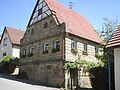
- One of the last historical buildings in the town center is the so-called Weingärtnerhaus from 1793 in Zollerstr. 10.
- The former Gasthaus Rose dates back to the late 15th century. A spring in the cellar supplied water for brewing beer and still feeds a pipe well today.
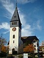
Ev. Johanneskirche

Old Town Hall

school

Weingärtnerhaus


Unterheinriet

- The Protestant Nikolauskirche has a Gothic choir tower from 1250 and was first mentioned in 1359. The narrow choir with ribbed vaults was rebuilt in 1578, and the nave in its current form was extended to the south in 1722. The extension of the church in 1722 served to install the original three-sided gallery with initially a leg for the organ, which spans the choir arch, and a sweeping south pore including the gain in space below. The roof ridge moved from the center of the tower to the south as a result of the roof, which was necessarily wider. The main entrance was also laid out from the south and the parterre and south pore stalls were oriented across the room axis with considerable depth to the pulpit opposite on the north wall. This spatial arrangement with an L-shaped gallery on the west and south side corresponds to a transverse church concept that has often been encountered in Württemberg since the Reformation , which incidentally attaches little importance to the altar in the narrow choir, but rather prefers the pulpit as the source of the proclamation. Since the east organ gallery was abandoned in 1887, the new organ by the Stuttgart organ builder Carl Gottlieb Weigle has been in the south pore above the main portal. The pulpit and baptismal font date from 1759. The furnishings with paintings are largely baroque , especially the gallery paintings in the parapet fields, as well as a painting with the baptism of Christ from 1688. In 1998 the painter Rut Hanselmann , then Heilbronn, and Mares Schultz (Stuttgart; 1920 - 2013) with a picture frieze. In 1997/98 they also created the four ship color windows with the motifs Bird in the Nest , The Vine , Annunciation to Maria and Ruth and Naemi .
- The rectory by the church was renewed like the church in the 18th century, a preserved loopholes indicates older origins. The building has only been a rectory since 1780, the previous building probably also served other purposes.
- The wine press completes the historical ensemble in the center of the village. Your age is unknown. The historical roof beams are said to have a resemblance to the carpentry work in the roof structure of the Ulm Minster. In 1832 the royal camera office acquired the wine press, which became the property of the municipality. The building was renovated and expanded in 1990; a. the library.
- Historic buildings can also be found in particular on Spreuerbergstrasse, which was built on early on. Building No. 18 with its striking and ornate stone facade was built by a quarry owner in 1809 as a residential building. There are other historic half-timbered properties in the vicinity.

Rectory

Wine press
Quarry owner's house

Half-timbered property Spreuerberg


Regular events
Since 2005 there has been a medieval castle festival at Stettenfels Castle every year with knight tournaments, jugglers, music and craftsmen. The festival has been taking place on May 1st and the following weekend since 2007 and now has several hundred participants and thousands of visitors.
Economy and Infrastructure
Viticulture

Untergruppenbach is a traditional wine-growing whose layers to Großlage Church vineyard in the range Württembergisch sub-country of the vineyard Württemberg belong. With the State Secretary Friedlinde Gurr , the place provided the German Wine Queen in 1976/77 . Before that, she had been the Württemberg wine queen in 1975/76 .
traffic
Untergruppenbach is connected to the national road network by the federal highway 81 ( Würzburg - Gottmadingen ).
Established businesses
The largest company based in Untergruppenbach is the automotive supplier Magna PT (formerly: Getrag ), whose corporate headquarters have been here since January 1, 2002. More than 1120 people are employed in the corporate headquarters, research and development and other departments of the company, which are also located in Untergruppenbach.
media
The daily newspaper Heilbronner Demokratie reported on the events in Untergruppenbach in its Süd-Ost (SO) edition as well as the weekly Untergruppenbacher gazette Die Brücke .
Public facilities
One of the approx. 20 NATO tank farms in Germany that is connected to the CEPS pipeline network is located in the forest north of the Obergruppenbach district . Lines from Philippsburg-Huttenheim and Boxberg (Baden) end here.
education
In Untergruppenbach there is the Stettenfelsschule in the Untergruppenbach district, a community school that includes grades 1 to 9 and 10, as well as another independent elementary school in the Unterheinriet district, the Eberhard-Schweizer-Grundschule Unterheinriet. The local library in the Untergruppenbach district with over 10,000 media units has around 1,500 users. In September 2017 the Stettenfelsschule starts with an all-day concept as an all-day school.
Personalities
Sons and daughters of the church
- Max von Gemmingen (1868–1949), born at Stettenfels Castle, Colonel of Württemberg
- Theodor Dipper (1903–1969), Protestant pastor and dean (born in Unterheinriet)
- Friedlinde Gurr-Hirsch (* 1954), politician ( CDU ), political state secretary in the Ministry of Food and Rural Areas Baden-Württemberg (2005–2011, since 2016), member of the state parliament of Baden-Württemberg
- Peter Uetz (* 1965), German molecular biologist and herpetologist, born in Untergruppenbach.
Other people associated with the community
- Friedrich Spieser (1902–1987), politician and publisher, long-time owner and resident of Stettenfels Castle
- Karl-Heinz Dähn (1926–2016), teacher and local history researcher, lived in Untergruppenbach
- Thomas Ring (1892–1983), painter, poet, astrologer, lived at Stettenfels Castle from 1962 to 1983
- Irmtraut Ring-Bilger (1910–1999), Austrian painter, draftsman
Individual evidence
- ↑ State Statistical Office Baden-Württemberg - Population by nationality and gender on December 31, 2018 (CSV file) ( help on this ).
- ↑ Natural areas of Baden-Württemberg . State Institute for the Environment, Measurements and Nature Conservation Baden-Württemberg, Stuttgart 2009
-
^ Source for the section on community structure:
Das Land Baden-Württemberg. Official description by district and municipality. Volume IV: Stuttgart district, Franconian and East Württemberg regional associations. Kohlhammer, Stuttgart 1980, ISBN 3-17-005708-1 . Pp. 97-99 - ↑ Source: untergruppenbach.de , accessed on December 24, 2007
- ↑ State Statistical Office, area since 1988 according to actual use for Untergruppenbach.
- ↑ a b Federal Statistical Office (ed.): Historical municipality register for the Federal Republic of Germany. Name, border and key number changes in municipalities, counties and administrative districts from May 27, 1970 to December 31, 1982 . W. Kohlhammer, Stuttgart / Mainz 1983, ISBN 3-17-003263-1 , p. 465 .
- ↑ "The whole thing looks like an execution" . In: Der Spiegel 4/1982, pp. 50–55 ( online )
- ^ Website of the Evangelical Church Community Untergruppenbach
- ^ Website of the Evangelical Church District Heilbronn
- ^ Website of the Evangelical Church District Weinsberg-Neuenstadt
- ^ Members: community Untergruppenbach. Retrieved March 11, 2018 .
-
^ Sources for the section coat of arms and flag:
Heinz Bardua: The district and community coat of arms in the Stuttgart administrative region . Theiss, Stuttgart 1987, ISBN 3-8062-0801-8 (district and municipality coat of arms in Baden-Württemberg, 1). P. 133
Eberhard Gönner: Book of arms of the city and district of Heilbronn with a territorial history of this area . Archive Directorate Stuttgart, Stuttgart 1965 (Publications of the State Archive Administration Baden-Württemberg, 9). P. 145 - ^ Julius Fekete : Art and cultural monuments in the city and district of Heilbronn ; Theiss, Stuttgart 2002, ISBN 3-8062-1662-2 , p. 301.
- ↑ Otto Friedrich: Evangelical churches in the deanery Weinsberg - picture reading book ; ed. Ev. Deanery Weinsberg, 2003, p. 48 f
- ^ Website of the festival
- ↑ GETRAG: GETRAG Untergruppenbach | GETRAG. Retrieved August 26, 2017 .
- ↑ The bridge at untergruppenbach.de
- ↑ Die Brücke online version at Lokalmatador.de
- ^ Tanja Ochs: Five new all-day schools approved . In: Heilbronn voice . February 23, 2017 ( from Stimme.de [accessed on February 23, 2017]).
literature
- Wilfried Sehm (editor): Untergruppenbach. Untergruppenbach, Unterheinriet, Donnbronn, Oberheinriet, Obergruppenbach, Vorhof. Homeland book of the community Untergruppenbach . Ed .: Municipality of Untergruppenbach. Deutscher Sparkassenverlag, Stuttgart 1992, ISBN 3-09-303987-8 .
- Doris and F. Eisenmann, Willi Schweiker (eds.): Gruppenbach and Heinriet in historical pictures . Geiger, Horb 1984.
- Friedrich Gutöhrlein: How it was at home. A hike through the community of Unterheinriet . Unterheinriet community, Unterheinriet 1969.
Web links

Abstatt | Bad Friedrichshall | Bad Rappenau | Bad Wimpfen | Beilstein | Brackenheim | Cleebronn | Eberstadt | Ellhofen | Eppingen | Erlenbach | Flein | Gemmingen | Güglingen | Gundelsheim | Hardthausen am Kocher | Ilsfeld | Ittlingen | Jagsthausen | Kirchardt | Langenbrettach | Lauffen am Neckar | Lehrensteinsfeld | Leingarten | Lion's Arch | Massenbachhausen | Möckmühl | Neckarsulm | Neckarwestheim | Neudenau | Neuenstadt am Kocher | Nordheim | Obersulm | Oedheim | Offenau | Pfaffenhofen | Roigheim | Schwaigern | Siegelbach | Talheim | Untereisesheim | Untergruppenbach | Weinsberg | Rams | Desert red | Zaberfeld