
Étrepigney
| Étrepigney | ||
|---|---|---|

|
|
|
| region | Bourgogne-Franche-Comté | |
| Department | law | |
| Arrondissement | Dole | |
| Canton | Mont-sous-Vaudrey | |
| Community association | Jura North | |
| Coordinates | 47 ° 8 ' N , 5 ° 42' E | |
| height | 207-262 m | |
| surface | 15.6 km 2 | |
| Residents | 430 (January 1, 2017) | |
| Population density | 28 inhabitants / km 2 | |
| Post Code | 39700 | |
| INSEE code | 39218 | |
 Winter landscape near Étrepigney |
||

Étrepigney is a French municipality with 430 inhabitants (at January 1, 2017) in the department of Jura in the region Bourgogne Franche-Comté . It belongs to the Arrondissement of Dole and the canton of Mont-sous-Vaudrey . The inhabitants call themselves the Étrepignaciens .
geography
The river Doubs forms the municipal boundary in the north. The settlement is touched in the north by a stream called Doulonne . The neighboring communities are La Barre in the north, Rans in the northeast, Plumont in the east, Chissey-sur-Loue in the southeast, Chatelay in the south, Germigney in the southwest, Our and La Bretenière in the west and Orchamps in the northwest.
Population development
| 1962 | 1968 | 1975 | 1982 | 1990 | 1999 | 2006 | 2011 |
|---|---|---|---|---|---|---|---|
| 262 | 279 | 252 | 297 | 321 | 357 | 379 | 420 |
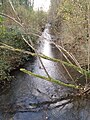
The Doulonne

The Doubs

museum

Saint-Etienne church
.JPG)


Web links
Commons : Étrepigney - collection of images, videos and audio files