
Mutigney
| Mutigney | ||
|---|---|---|
|
||
| region | Bourgogne-Franche-Comté | |
| Department | law | |
| Arrondissement | Dole | |
| Canton | Authume | |
| Community association | Jura North | |
| Coordinates | 47 ° 17 ' N , 5 ° 33' E | |
| height | 188-233 m | |
| surface | 8 km 2 | |
| Residents | 171 (January 1, 2017) | |
| Population density | 21 inhabitants / km 2 | |
| Post Code | 39290 | |
| INSEE code | 39377 | |
 The Ognon at Mutigney |
||

Mutigney is a French commune in the Jura department in the region of Bourgogne Franche-Comté . It belongs to the Arrondissement of Dole and the Canton of Authume .
geography
Mutigney is the northernmost municipality in the Jura department. It borders on Broye-Aubigney-Montseugny in the north, Pesmes in the northeast, Dammartin-Marpain in the southeast, Champagney in the southwest and Cléry in the northwest . Mutigney is passed by the Ognon .
Population development
| year | 1962 | 1968 | 1975 | 1982 | 1990 | 1999 | 2008 | 2014 |
|---|---|---|---|---|---|---|---|---|
| Residents | 200 | 191 | 175 | 169 | 161 | 143 | 149 | 167 |
Attractions
- Mutigney Castle, built in 1450 by order of Herman Vaudrey , monument historique since July 22, 1971
- "Les lavoirs-fontaines", two public washing places Lavoir built in the 18th century on Rue Saint-Souplet and Rue du Château
- Saint-Michel chapel
- Church "Église de l'Assomption" from the 18th century
- 15th century castle
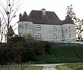
Mutigney Castle

Lavoir on Rue Saint-Souplet

Lavoir on the Rue du Château
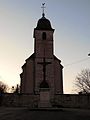
Mutigney Church

.jpg)
.jpg)

Web links
Commons : Mutigney - collection of images, videos and audio files