Our (Jura)
| Our | ||
|---|---|---|

|
|
|
| region | Bourgogne-Franche-Comté | |
| Department | law | |
| Arrondissement | Dole | |
| Canton | Mont-sous-Vaudrey | |
| Community association | Jura North | |
| Coordinates | 47 ° 8 ' N , 5 ° 39' E | |
| height | 207-261 m | |
| surface | 13.86 km 2 | |
| Residents | 140 (January 1, 2017) | |
| Population density | 10 inhabitants / km 2 | |
| Post Code | 39700 | |
| INSEE code | 39400 | |
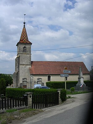
 Saint-Pierre church |
||
Our is a commune with 140 inhabitants (at January 1, 2017) in the department of Jura in the region Bourgogne Franche-Comté . It belongs to the Arrondissement of Dole and the canton of Mont-sous-Vaudrey .
geography
The community is located around 13 kilometers northeast of Dole on the northern edge of the Forêt Domaniale de Chaux forest . The neighboring municipalities are Orchamps in the northeast, La Bretenière and Étrepigney in the east, Santans in the south, Éclans-Nenon in the west and Lavans-lès-Dole in the northwest. The Doubs River runs along the northwestern municipal boundary . The municipality marker is almost rectangular with a width of about two kilometers and a main longitudinal extension in north-south direction (from the Doubs to the border with Santans). In the forest of Chaux is the Etang de la Plaine du Clos a small lake.
The municipality's capital can be reached via the D76 département road. All higher-ranking traffic connections along the Doubs run in the northern neighboring communities.
Population development
| year | 1968 | 1975 | 1982 | 1990 | 1999 | 2006 | 2016 |
| Residents | 104 | 102 | 118 | 140 | 169 | 161 | 139 |
Attractions
- Old bread oven from the 18th century in the former forest settlement of Les Baraques du Cinq - Monument historique
Web links
Individual evidence
- ↑ Bread oven (Four à pain) in the Base Mérimée of the French Ministry of Culture (French)
