
Rans (Jura)
| Rans | ||
|---|---|---|
|
||
| region | Bourgogne-Franche-Comté | |
| Department | law | |
| Arrondissement | Dole | |
| Canton | Mont-sous-Vaudrey | |
| Community association | Jura North | |
| Coordinates | 47 ° 8 ' N , 5 ° 44' E | |
| height | 209-269 m | |
| surface | 6.14 km 2 | |
| Residents | 535 (January 1, 2017) | |
| Population density | 87 inhabitants / km 2 | |
| Post Code | 39700 | |
| INSEE code | 39452 | |

Rans is a French municipality with 535 inhabitants (at January 1, 2017) in the department of Jura in the region Bourgogne Franche-Comté . It belongs to the Arrondissement of Dole and the canton of Mont-sous-Vaudrey .
geography
The municipality is located around 25 kilometers southwest of Besançon on the left bank of the Doubs River . She borders
- in the north at Ranchot ,
- to the east at Fraisans ,
- in the south at Plumont ,
- to the west at Étrepigney ,
- to the northwest at La Barre .
history
From 1790 to 1794, the municipality of Rans gradually took over the previously independent municipality of Raudey.
Population development
| 1962 | 1968 | 1975 | 1982 | 1990 | 1999 | 2006 | 2016 |
|---|---|---|---|---|---|---|---|
| 303 | 350 | 402 | 404 | 389 | 416 | 448 | 538 |
Attractions
- The forge of Rans, in French Forges de Rans , was established in 1705 on the Doubs River. The building was declared a Historic Monument on December 21, 1984 .
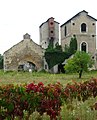
The Rans forge

Drawing by Emile Bourdelin from 1859

Hammer forge (around 1859)

Derivation of liquid iron (around 1859)


Web links
Commons : Rans - collection of images, videos and audio files
Individual evidence
- ↑ Forges de Rans in the Base Mérimée of the French Ministry of Culture (French)