
Moissey
| Moissey | ||
|---|---|---|

|
|
|
| region | Bourgogne-Franche-Comté | |
| Department | law | |
| Arrondissement | Dole | |
| Canton | Authume | |
| Community association | Grand Dole | |
| Coordinates | 47 ° 12 ' N , 5 ° 31' E | |
| height | 217-377 m | |
| surface | 10.63 km 2 | |
| Residents | 563 (January 1, 2017) | |
| Population density | 53 inhabitants / km 2 | |
| Post Code | 39290 | |
| INSEE code | 39335 | |
 The Mairie |
||

Moissey is a French commune in the Jura department in the region of Bourgogne Franche-Comté . It belongs to the Arrondissement of Dole and the Canton of Authume .
geography
The departmental road D475 connects Moissey with Menotey in the southwest and Offlanges in the northeast. The other neighboring communities are Montmirey-la-Ville in the north, Montmirey-le-Château in the northeast, Amange in the southeast and Gredisans , Archelange and Châtenois in the south.
The municipality marker has shares in Mont Guérin in the east and the Forêt de la Serre in the west.
Population development
| 1962 | 1968 | 1975 | 1982 | 1990 | 1999 | 2006 | 2014 |
|---|---|---|---|---|---|---|---|
| 367 | 340 | 346 | 381 | 426 | 527 | 559 | 552 |

Saint-Gengulphe church
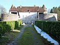
Castle of Moissey


Web links
Commons : Moissey - collection of images, videos and audio files