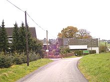
Umminghausen
|
Umminghausen
City of Radevormwald
Coordinates: 51 ° 13 ′ 53 ″ N , 7 ° 21 ′ 40 ″ E
|
||
|---|---|---|
| Height : | 359 m above sea level NHN | |
| Postal code : | 42477 | |
| Area code : | 02195 | |
|
Location of Ümminghausen in Radevormwald |
||
Ümminghausen is a village in Radevormwald in the Oberbergischer Kreis in the North Rhine-Westphalian administrative district of Cologne in Germany .
Location and description
The place is in the north of the Radevormwald urban area. The neighboring towns are Kronenberg , Möllersbaum , Oberönkfeld , Unterm Busch and Jakobsholt .
The Ümminghausen Brook, which flows into the Brunsbach, has its source in Ümminghausen . In the southeast of the village lies the source of the Ümminghauser Siepen, which flows into the Ümminhauser Bach .
Politically, the place is represented by the direct candidate from electoral district 170 in the city council of Radevormwald.
history
Ümminghausen is mentioned for the first time in 1433 or 1434. On the occasion of the naming of "war damage caused by the devastation of the troops of Cologne Archbishop Dietrich von Moers", the place is called "Ymminchuyss".
In 1715, the Topographia Ducatus Montani map shows the location of Ümminghausen under the name “innighusen”.
Hiking trails
300 m south-west of Ümminghausen, the local circular hiking trail A6, which has been awarded the hiking sign A6, passes.
Web links
Individual evidence
- ↑ Wupperverband; River basin geographic information system
- ^ Stadt Radevormwald, public announcement of October 20, 2008; Allocation of electoral districts for the election of the Radevormwald city council (municipal elections 2009)
- ^ Klaus Pampus: First documentary mentions of Oberbergischer places (= contributions to Oberbergischen history. Special volume 1). Oberbergische Department 1924 eV of the Bergisches Geschichtsverein, Gummersbach 1998, ISBN 3-88265-206-3 .
- ↑ Topographical Information Management TIM-online, provided by the Cologne District Government


