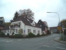
Keilbeck
|
Keilbeck
City of Radevormwald
Coordinates: 51 ° 13 ′ 5 ″ N , 7 ° 18 ′ 45 ″ E
|
||
|---|---|---|
| Height : | 296 m above sea level NHN | |
| Postal code : | 42477 | |
| Primaries : | 02195, 02191 | |
|
Location of Keilbeck in Radevormwald |
||
Keilbeck is a district of Radevormwald in the Oberbergischer Kreis in the North Rhine-Westphalian administrative district of Cologne in Germany .
It is also called Die Keilbeck by the people of Radevormwald and is about seven kilometers from the city center. It lies south of Dahlerau and east of Dahlhausen and is one of the so-called Wupperorte .
geography
Keilbeck is an elongated district and is shaped by the steep valley of the Wupper towards the east. While the north-westerly point of the district is 210 meters above sea level, Keilbeck is located 1.3 km further east to Herkingrade at almost 300 meters above sea level.
Residents
In the local elections on September 26, 2004, the Ev. Parish hall on Siedlungsweg in Keilbeck polling station and formed electoral district 140. The district had 853 eligible voters; 468 of them voted. Thomas Lorenz ( CDU ) has since represented the constituency by direct mandate in the city council of Radevormwald.
Infrastructure
All the components of a local supply center are available: a primary school and a kindergarten ensure childcare and school supplies. The primary school is now called the Wupper Community Primary School . It was built in 1966 as a primary school and has existed as a primary school since 1968, but there was already a school building in Keilbeck by the middle of the 19th century. In 1870 the school moved to the newly built Protestant parish hall, where it stayed until 1878. There are currently around 180 students in eight classes.
The XC circular hiking trail towards Radevormwald starts from Keilbeck and then continues towards Halver . This path was unofficially (and therefore actually illegal, see Section 59, Paragraph 2 LandschaftsG NW in the currently valid version) for a mountain bike race. Since hiking signs are relatively rare and do not meet the usual standards, they should only be walked with local knowledge and a map.
Transport links
You can reach Keilbeck via Landesstraße 414. The second main traffic axis, Keilbecker Straße, continues to the Herkingrade district . The citizen bus line 4 "Remlingrader" connects the village to the local public transport system ( ÖPNV ) on Mondays, Tuesdays and Thursdays . Two public bus lines go to and from Remscheid (line 659) and Wuppertal (line 626) to the Keilbeck.
history
The first mention of Keilbeck took place in 1515 in church accounts with the name Keylhecke . The place was shaped in the age of industrialization by the traditional history of the cloth factories on the Wupper , some of whose workers lived in Keilbeck.
In 1815/16 the place had 51 inhabitants. In 1832 the place belonged to the parish Remlingrade of the rural outskirts of the mayor's office Radevormwald . The place, categorized as a hamlet according to the statistics and topography of the administrative district of Düsseldorf , had five houses and one agricultural building at that time. At that time 53 people lived in the place, 13 Catholic and 40 Protestant faith. In 1888, 13 houses with 205 inhabitants are listed in the community dictionary of the Rhine Province .
Cultural and club life
- Ev. Trombone Choir Keilbeck
- Ev. Dahlerau parish with the parish hall in Keilbeck
- Gymnastics and sports club TuSpo Dahlhausen 1883 eV
Individual evidence
- ↑ a b Johann Georg von Viebahn : Statistics and topography of the administrative district of Düsseldorf. Part 2: Containing the statistical table of places and distances and the alphabetical index of place names. Schreiner, Düsseldorf 1836, p. 10 .
- ^ Royal Statistical Bureau (Prussia) (Ed.): Community encyclopedia for the Rhineland province. Based on the materials from the census of December 1, 1885 and other official sources (= community encyclopedia for the Kingdom of Prussia. Vol. 12, ZDB -ID 1046036-6 ). Publishing house of the Royal Statistical Bureau, Berlin 1888.


