Wheels
|
Wheels
City of Radevormwald
Coordinates: 51 ° 11 ′ 46 ″ N , 7 ° 22 ′ 52 ″ E
|
||
|---|---|---|
| Height : | 380 m above sea level NHN | |
| Residents : | 189 (Nov. 3, 2004) | |
| Postal code : | 42477 | |
| Area code : | 02195 | |
|
Location of wheels in Radevormwald |
||
|
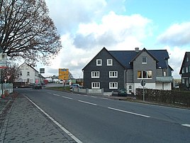
Crossing area of the village of Rädereichen from the direction of Hückeswagen
|
||
Rädereichen is a place and district of Radevormwald in the Oberbergischer Kreis in the North Rhine-Westphalian administrative district of Cologne in Germany .
Location and description
It is located in the east of Radevormwald and has gained in importance for the city in recent decades. It is a traffic junction where the federal road 483 from the direction of Hückeswagen , the district road K11 from the direction of the Bevertalsperre and the federal road 229 meet as the main traffic axis. At this intersection is a former blacksmith's shop, now a gas station, heating oil and tire trade.
Furthermore, the city of Radevormwald designated an important industrial area north of Rädereichen and west of Grüne and Grafweg.
Rädereichen is the source area for the Uelfe , an important tributary of the Wupper .
history
The place is shown in the map Topographischeaufnahme der Rheinlande from 1825. The name of the location is indicated with “ speaking spaces ”.
In 1815/16 there were 24 residents in the village. In 1832 Rädereichen belonged to the parish Radevormwald of the Radevormwald mayor . The place, categorized as a hamlet according to the statistics and topography of the administrative district of Düsseldorf , had three residential buildings and an agricultural building at that time. At that time, 14 residents lived in the village, all of whom were Protestant.
In the municipality lexicon for the province of Rhineland in 1885 seven houses with 83 inhabitants are given. In 1895 the place had eight houses with 85 inhabitants, in 1905 eight houses and 98 inhabitants.
Up until June 15, 1959, Rädereichen was the location of a landmark of Radevormwald, a 25 meter high water tower . In December 2004 , work began on expanding the traffic junction with a roundabout. The work was completed in spring 2005.
bus connections
Rädereichen is connected to local public transport via the 339 (VRS / OVAG) stop in town.
Web links
Individual evidence
- ^ Historika25, Landesvermessungsamt NRW, sheet 4810, Wipperfürth
- ↑ Johann Georg von Viebahn : Statistics and Topography of the Administrative District of Düsseldorf , 1836
- ↑ Königliches Statistisches Bureau (Prussia) (Ed.): Community encyclopedia for the Rhineland Province, based on the materials of the census of December 1, 1885 and other official sources, (Community encyclopedia for the Kingdom of Prussia, Volume XII), Berlin 1888.
- ↑ Königliches Statistisches Bureau (Prussia) (Ed.): Community encyclopedia for the Rhineland Province, based on the materials of the census of December 1, 1895 and other official sources, (Community encyclopedia for the Kingdom of Prussia, Volume XII), Berlin 1897.
- ↑ Königliches Statistisches Bureau (Prussia) (Ed.): Community encyclopedia for the Rhineland Province, based on the materials of the census of December 1, 1905 and other official sources, (Community encyclopedia for the Kingdom of Prussia, Volume XII), Berlin 1909.
- ↑ Busnetz 2010, Oberbergischer Kreis, published by Verkehrsverbund Rhein-Sieg GmbH


