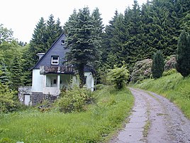
In the Wildental
|
In the Wildental
City of Radevormwald
Coordinates: 51 ° 14 ′ 38 " N , 7 ° 18 ′ 50" E
|
||
|---|---|---|
| Height : | 226 m above sea level NHN | |
| Postal code : | 42477 | |
| Area code : | 02195 | |
|
Location of Im Wildental in Radevormwald |
||
Im Wildental is a place to live in Radevormwald in the Oberbergischer Kreis in the North Rhine-Westphalian administrative district of Cologne in Germany .
Location and description
In the Wildental is located in the far northwest of Radevormwald directly on the city limits to Ennepetal in the valley of the Spreeler Bach . The Spreeler Bach flows into the Wupper 700 meters below Im Wildental .
Neighboring places are Oege , Pastoratshof and Im Wiesengrund . The residential area in a wooded area can be reached via a road connected to Landesstraße 414 at Oege and a paved field path.
The Wappenweg , a hiking trail around the town of Ennepetal, leads through Im Wildental.
history
The location of the residential area is shown for the first time in the official topographic map from 1968.
A section of the Bergische Landwehr , which reached from Wuppertal-Elberfeld to Marienheide-Krommenohl, ran through the valley of the Spreeler Bach .
Individual evidence
- ↑ Wupperverband; River basin geographic information system
- ^ Historika25, Landesvermessungsamt NRW, sheet 4709, Barmen
- ^ Wilhelm Engels : The Landwehr in the outskirts of the Duchy of Berg. In: Journal of the Bergisches Geschichtsverein. 66. Vol., 1938, ISSN 0067-5792 , pp. 67-278, here pp. 88 and 89.


