Mermbach
|
Mermbach
City of Radevormwald
Coordinates: 51 ° 12 ′ 25 ″ N , 7 ° 22 ′ 22 ″ E
|
||
|---|---|---|
| Height : | 347 m above sea level NHN | |
| Postal code : | 42477 | |
| Area code : | 02195 | |
|
Location of Mermbach in Radevormwald |
||
|
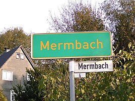
Place-name sign and homestead in Mermbach
|
||
Mermbach is a village in Radevormwald in the Oberbergischer Kreis in the North Rhine-Westphalian administrative district of Cologne in Germany .
Location and description
The place is in the northeast of the urban area in the valley of the Uelfebach on the edge of the industrial area Mermbach. 200 meters south of the springs in the Ülfe opens Mermbach . Neighboring places are Uelfe I , Uelfe II , Uelfe III , and Radevormwald .
Politically, the court is represented by the direct candidate from electoral district 10 in the city council of Radevormwald.
history
In a list of a reformed consortium from January 20, 1805 about the income of the pastorate in Wiedenhofe, lands in the "Mermbeck" are named. In the map topographical survey of the Rhineland from 1825, the place is listed with the name "Marbach". In the Prussian premiere from 1840 to 1843, the yard can be seen, but not named. The historical topographical map from 1892 to 1894 ( Prussian new admission ) calls the place name in use today "Mermbach".
Hiking trails
The A3 circular hiking trail runs past the village about a hundred meters away.
Individual evidence
- ↑ Wupperverband; River basin geographic information system
- ↑ Topographical Information Management TIM-online, provided by the Cologne District Government
- ^ Stadt Radevormwald, public announcement of October 20, 2008; Allocation of electoral districts for the election of the Radevormwald city council (municipal elections 2009)
- ^ Johann H. Becker: History of the city of Rade vorm Wald (in the government district of Düsseldorf) with reference to the state history. Mostly based on archival sources. Schwann in Commission, Cologne et al. 1864, digitized .
- ↑ Historika25, Landesvermessungsamt NRW, sheet 4710, Radevormwald


