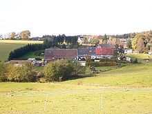
Grafweg (Radevormwald)
|
Grafweg
City of Radevormwald
Coordinates: 51 ° 12 ′ 0 ″ N , 7 ° 23 ′ 47 ″ E
|
||
|---|---|---|
| Height : | 370 m above sea level NHN | |
| Residents : | 92 (December 20, 2004) | |
| Postal code : | 42477 | |
| Area code : | 02195 | |
|
Location of Grafweg in Radevormwald |
||
Grafweg is a place in Radevormwald in the Oberbergischer Kreis in the North Rhine-Westphalian administrative district of Cologne in Germany .
location
Grafweg is located in the east of Radevormwald directly on the federal road 229 , which leads from Radevormwald to Halver . Other neighboring towns are Grüne , Feldmannshaus , Böhlefeldshaus , Hahnenberg and Rädereichen .
The Kreuzbach rises south of the village , where the Hirschberg is also located ( 387.2 m above sea level ).
history
Grafweg is mentioned for the first time in 1469 as "Graffwege". This is done in a document in which Duke Gerhard von Jülich-Berg grants a Rutger Haken the compulsory meal for 22 houses near Radevormwald. (see PA Heuser: Stadt und Pfarrei Radevormwald 1990, p. 149). The document is available in the Düren city and district archive under "Jülich-Berg I, 1367".
politics and society
Grafweg is in Radevormwald's municipal electoral district 181, which in September 2004 had 922 eligible voters.
Churches
- Free evangelical community Radevormwald-Grafweg, also church building.


