Asian Highway 1
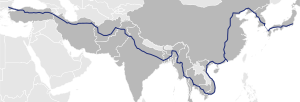
The Asian Highway 1 (AH1) ( English for "Asian Highway 1") is the longest connection in the Asian Highway Project . With a projected length of 20,557 km, the strait leads from Tokyo (Japan) via Korea , the People's Republic of China , Southeast Asia , India , Iran to the Bosporus (Turkey).
Similar to the European roads, existing routes are also given the designation "AH1". The participating states have undertaken to increase the standard of the transnational roads and to develop them into motorway-like highways for a connection like the AH1 .
Japan
With the designation as AH1 since November 2003, the trunk road in Japan runs over 1200 kilometers along the following (toll) highways:
-

 Tokyo City Motorways C1 (Inner Ring) and 3 (Shibuya Line)
-
 Tōmei Highway , from Tokyo to Komaki
-
 Meishin Highway , from Komaki via Kyōto to Suita
-
 Chūgoku Highway , from Suita to Kobe
-
 San'yō highway , from Kobe via Hiroshima to Yamaguchi
-
 Chūgoku Highway, from Yamaguchi to Shimonoseki
-
 Kammon Highway ( Kammon Bridge ), from Shimonoseki to Kitakyushu
-
 Kyushu Highway , from Kitakyushu to Fukuoka
-

 Fukuoka Highway 4 and 1 in Fukuoka
The AH1 runs from Fukuoka as a ferry connection to Busan in South Korea - the proposed Japan-Korea tunnel could enable a connection with a slab track.
South Korea

The AH1 largely followed the Gyeongbu Highway :
-
 Highway 1 on the Gyeongbu Expressway from Busan to Hannam Bridge in Seoul and
 - Highway 1 of the one-way road from Seongsan Bridge in Seoul to Panmunjeom in Paju , Gyeonggi-do .
- North Korea border

North Korea
- South Korea border

P'anmunjǒm via Gaeseong and P'yǒngyang ( Pyongyang-Kaesŏng expressway ) to Sinǔiju via the Pyongyang-Sinŭiju expressway
- Frontier People's Republic of China

China
- North Korea border

-
 G304: Dandong - Shenyang
-
 G102: Shenyang - Beijing
-
 S382: Beijing - Shijiazhuang
-
 G107: Shijiazhuang - Zhengzhou
-
 G310: Zhengzhou - Xinyang - Wuhan
-
 G107: Wuhan - Changsha
-
 G322: Nanning - Youyiguan - Guangzhou - Xiangtan
- Vietnam border

Vietnam
- Frontier People's Republic of China

-
 National Road 1A : Ho Chi Minh City - Biên Hòa - Nha Trang - Hội An - Đà Nẵng - Huế - Đông Hà - Dong Hoi - Vinh - Hanoi
- Highway 22 : Moc Bai - Ho Chi Minh City
-
Highway 279 : Dong Dang - Huu Nghi
- Trunk road 51 : junction from Bien Hoa to Vung Tau
- Cambodia border

Cambodia
- Vietnam border

-
 National Road 1 : Bavet - Phnom Penh
-
 National Road 5 : Phnom Penh - Poipet
- Border thailand

Thailand
- Cambodia border

-
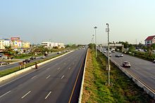
 Thai Highway 33 : Aranyaprathet ( province of Sa Kaeo ) - Nakhon Nayok - Hin Kong (District Nong Khae , Saraburi province )
 -
 Thanon Phahonyothin : Hin Kong (District Nong Khae , Saraburi province ) - Bang Pa In
-
 Thanon Phahonyothin : Branch from Bang Pa In to Bangkok
-
-
 Thai Highway 32 : Bang Pa In - Chai Nat
-
 Thanon Phahonyothin : Chai Nat - Nakhon Sawan - Tak
-
 Thai Highway 105 Tak - Mae Sot
- Myanmar border

Myanmar
- Border thailand

- Highway 8 (NH8) Myawaddy - Payagyi
- Highway 1 (NH1) Payagyi - Meiktila - Mandalay - Tamu
- Border India

India
- Myanmar border

- NH 39 , Moreh - Imphal - Kohima - Dimapur
- NH 36 , Dimapur - Nagaon
- NH 37 , Nagaon - Numaligarh - Jorabat
- NH 40 , Jorabat - Shillong - Dawki
- Bangladesh border

Bangladesh
- Border India

- N2 Tamabil - Sylhet - Katchpur - Dhaka
- N4 Dhaka - Tangail
- N405 Tangail - Kamarkhanda
- N704 Kamarkhanda - Jessore
- N706 Jessore - Benapole
- Border India

India
- Bangladesh border

- NH 35 , Petrapole - Barasat
- NH 34 , Barasat - Kolkata
- NH 2 , Kolkata - Barhi - Kanpur - Agra - New Delhi
- NH 1 , New Delhi - Attari
- Pakistan border

Pakistan
- Border India

- Wagah - Lahore
-
 M-2 : Lahore - Islamabad
-
 M-1 : Islamabad - Peshawar
-
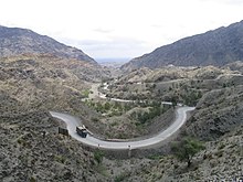
 N-5 : Peshawar - Torcham
- Khyber Pass
- Afghanistan border

Afghanistan
- Pakistan border

- Khyber Pass
- A01 Torkham - Jalalabad - Kabul - Kandahar - Dilaram - Herat - Islam Qala
- Iran border

Iran
- Afghanistan border

- A101 A78-2-13: Road 22: Dogharun - Sang Bast - Mashhad
- A78- 2 Road 44: Mashhad - Eman Taqi
- A83- 6: Eman Taqi - Sabzevar - Damghan - Semnan - Tehran
- A01-4 Freeway 2: Tehran
- A01-4-5: Qazvin
- A01- 4: Tabriz - Eyvoghli - Bazargan
- Border Turkey

Turkey and connection to European route 80
- Iran border

-
 European route 80 / trunk road 100 Gürbulak - Doğubeyazıt - Aşkale - Refahiye - Sivas
-
 European route 88 / trunk road 100 Sivas - Ankara
-
 European route 89 / highway O-4 Ankara - Gerede - İstanbul
-
 European Route 80 / O-2 Motorway Istanbul - Fatih Sultan Mehmet Bridge
-
 European route 80 / O-3 motorway Istanbul - Edirne
-
 European route 80 / trunk road 100 Edirne - Kapıkule
- Bulgaria border

The route of the AH1 is also marked as European route 80 in Turkey - this connection leads from the border with Bulgaria at Kapitan Andreevo / Kapıkule to Sofia , from there on to Pristina , Dubrovnik , Pescara , Rome , Genoa , Nice , Toulouse , Burgos , Salamanca to Lisbon .
media
- fernOst - From Berlin to Tokyo - Road trip along Asian Highway 1, an Arte / RBB co-production.
Individual evidence
- ^ Economic and Social Commission for Asia and the Pacific, 2003 Asian Highway Handbook ( Memento of April 14, 2012 in the Internet Archive ) (PDF; 2.3 MB), 2003, page 3
- ^ Economic and Social Commission for Asia and the Pacific, 2003 Asian Highway Handbook ( Memento of April 14, 2012 in the Internet Archive ) (PDF; 2.3 MB), 2003, page 54
- ↑ ア ジ ア ハ イ ウ ェ イ 標識 の 設置 場所 . MLIT , accessed December 5, 2011 (Japanese).
- ^ Economic and Social Commission for Asia and the Pacific, 2003 Asian Highway Handbook ( Memento from April 14, 2012 in the Internet Archive ) (PDF; 2.3 MB), 2003, page 54 shows an aerial photo of the Yokohama Aoba Interchange, placing AH1 clearly on the Tomei Expressway rather than the other Tokyo-Nagoya expressway, the Chūō Expressway .
- ↑ rhd.gov.bd (PDF; 2.8 MB)


