Crecy-la-Chapelle
| Crecy-la-Chapelle | ||
|---|---|---|

|
|
|
| region | Île-de-France | |
| Department | Seine-et-Marne | |
| Arrondissement | Meaux | |
| Canton | Serris | |
| Community association | Pays Créçois | |
| Coordinates | 48 ° 52 ' N , 2 ° 54' E | |
| height | 45–157 m | |
| surface | 15.78 km 2 | |
| Residents | 4,531 (January 1, 2017) | |
| Population density | 287 inhabitants / km 2 | |
| Post Code | 77580 | |
| INSEE code | 77142 | |
| Website | http://www.crecylachapelle.eu/ | |
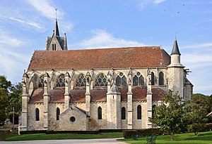
 Notre-Dame church in Crecy-la-Chapelle |
||
Crecy-la-Chapelle is a French commune with 4531 inhabitants (at January 1, 2017) in the department of Seine-et-Marne in the region Ile-de-France . It belongs to the Arrondissement of Meaux and the Canton of Serris .
geography
The city lies on the banks of the Grand Morin River .
Districts: Crécy Bourg, Montbarbin, Serbonne, La Chapelle, Libernon, Mongrolle, Ferolles, Montaudier
Neighboring communities: Bouleurs , Villiers-sur-Morin , Couilly-Pont-aux-Dames , Voulangis , Guérard , Maisoncelles-en-Brie
history
The municipality of Crécy-la-Chapelle was formed on October 1, 1972 from the communities of Crécy-en-Brie and La-Chapelle-sur-Crécy. The name Crécy appears for the first time in the 7th century as Criscecus, Crideciacavico or Creciacum . The first fortress was built in the 9th century (see county Crécy ).
Population development
| year | 1962 | 1968 | 1975 | 1982 | 1990 | 1999 | 2007 | 2017 |
| Residents | 1849 | 1928 | 2193 | 2413 | 3222 | 3851 | 4056 | 4531 |
| Sources: Cassini and INSEE | ||||||||
Attractions
- Notre-Dame-de-l'Assomption Collegiate Church
- Belfry , built in 1865
- Maison Corot
See also: List of Monuments historiques in Crécy-la-Chapelle
Town twinning
- Pielenhofen in Germany
literature
- Le Patrimoine des Communes de la Seine-et-Marne. Flohic Editions, Volume 1, Paris 2001, ISBN 2-84234-100-7 , pp. 360-365.
Web links
- Crécy-la-Chapelle at annuaire-mairie.fr (French)
