
Müllenbach (near Mayen)
| coat of arms | Germany map | |
|---|---|---|
_COA.svg)
|
Coordinates: 50 ° 13 ' N , 7 ° 4' E |
|
| Basic data | ||
| State : | Rhineland-Palatinate | |
| County : | Cochem cell | |
| Association municipality : | Kaisersesch | |
| Height : | 470 m above sea level NHN | |
| Area : | 4.27 km 2 | |
| Residents: | 624 (Dec. 31, 2019) | |
| Population density : | 146 inhabitants per km 2 | |
| Postal code : | 56761 | |
| Area code : | 02653 | |
| License plate : | COC, ZEL | |
| Community key : | 07 1 35 067 | |
| Association administration address: | Am Römerturm 2 56759 Kaisersesch |
|
| Website : | ||
| Local Mayor : | Andreas Klotz | |
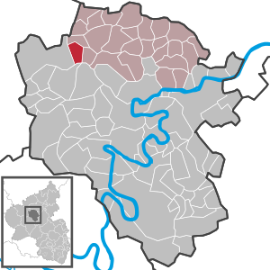
| Location of the local community Müllenbach in the district of Cochem-Zell | ||
  |
||

Müllenbach in der Eifel is a municipality in the district of Cochem-Zell in Rhineland-Palatinate . It belongs to the Kaisersesch association.
history
In 1036, Müllenbach is said to have been mentioned for the first time as "Michelembach sup Cumitato"; the documentary mention is only certain for 1333. In 1548, Kurtrier took over the sovereign rights over Müllenbach from the Counts of Virneburg . Müllenbach belonged to the Monreal Office and the Masburg High Court . The high court Masburg was a fiefdom of the Counts of Virneburg. In the Trier fire book from 1563 there are 23 fireplaces (households) in Müllenbach (Moelenbach).
In 1794 French revolutionary troops annexed the Left Bank of the Rhine , from 1798 to 1814 Müllenbach belonged to the canton of Kaisersesch in the Koblenz arrondissement of the Rhine-Moselle department . The Munizipalrat (Müllenbacher community representative in the Mairie Kaisersesch) was the citizen Felser in 1808. There was a school teacher in town.
Due to the resolutions at the Congress of Vienna (1815), the region was assigned to the Kingdom of Prussia . Under the Prussian administration, the municipality of Müllenbach became part of the mayor's office in Kaisersesch in the Cochem district , which belonged to the new administrative district of Koblenz and, from 1822, to the Rhine province .
The municipality of Müllenbach has been part of the state of Rhineland-Palatinate since 1946 , has belonged to the Kaisersesch association since 1968 and to the Cochem-Zell district since 1969 .
- Statistics on population development
The development of the population of Müllenbach, the values from 1871 to 1987 are based on censuses:
|
|
Municipal council
The municipal council in Müllenbach consists of twelve council members, who were elected in the local elections on May 26, 2019 in a personalized proportional representation, and the honorary local mayor as chairman. The twelve seats in the municipal council are divided between two groups of voters .
Personalities
- Johann Theodor Regnier (1810-1859), German attorney-at-law
See also
,_St._Hubertus_02.JPG)
Web links
- Local community Müllenbach on the website of the association community Kaisersesch
- Literature about Müllenbach in the Rhineland-Palatinate State Bibliography
Individual evidence
- ↑ State Statistical Office of Rhineland-Palatinate - population status 2019, districts, communities, association communities ( help on this ).
- ^ Wilhelm Fabricius : Explanations of the historical atlas of the Rhine Province, Volume 2: The map of 1789. Bonn 1898, pp. 138, 155, 210.
- ↑ Handbook for the residents of the Rhine-Mosel Department , Koblenz: Prefecture-Buchdruckerey, 1808, p. 65 ( www.dilibri.de )
- ^ Topographical-statistical overview of the government district of Coblenz , Coblenz: Hölscher, 1843, p. 38 ( www.dilibri.de )
- ↑ State Statistical Office Rhineland-Palatinate - regional data
- ^ The Regional Returning Officer Rhineland-Palatinate: Local elections 2019, city and municipal council elections

Alf | Alflen | Altlay | Alt-trimmed | Auderath | Bad Bertrich | Beilstein | Beuren | Binningen | Blankenrath | Brachtendorf | Bremm | Briedel | Brieden | Briedern | Brohl | Bruttig-Fankel | Büchel | Bullay | Cochem | Dohr | Durfus | Düngenheim | Ediger-Eller | Ellenz-Poltersdorf | Eppenberg | Serious | Eulgem | Faid | Felt | Forst (Eifel) | Forst (Hunsrück) | Gamling | Gevenich | Gillenbeuren | Greimersburg | Grenderich | Hambuch | Haserich | Hauroth | Hesweiler | Illerich | Kaifenheim | Kail | Kaisersesch | Kalenborn | Kliding | Klotten | Country core | Laubach | Leienkaul | Lie | Liesenich | Lütz | Lutzerath | Masburg | Mesenich | Medium- bodied | Möntenich | Moritzheim | Mosel core | Tired (Moselle) | Müllenbach | Neef | Nehren | Panzweiler | Peterswald -öffelscheid | Pomerania | Pünderich | Reidenhausen | Roes | Sankt Aldegund | Showers | Schmitt | Senheim | Sosberg | Tellig | Treis cards | Elms | Urmersbach | Urschmitt | Valwig | Wagenhausen | Walhausen | Hamlet | Wirfus | Wollmerath | Zell (Mosel) | Zettingen