
Bad Endorf
| coat of arms | Germany map | |
|---|---|---|

|
Coordinates: 47 ° 54 ' N , 12 ° 18' E |
|
| Basic data | ||
| State : | Bavaria | |
| Administrative region : | Upper Bavaria | |
| County : | Rosenheim | |
| Height : | 522 m above sea level NHN | |
| Area : | 40.11 km 2 | |
| Residents: | 8376 (Dec. 31, 2019) | |
| Population density : | 209 inhabitants per km 2 | |
| Postal code : | 83093 | |
| Area code : | 08053 | |
| License plate : | RO , AIB , WS | |
| Community key : | 09 1 87 128 | |
| Market structure: | 49 districts | |
Market administration address : |
Bahnhofstrasse 6 83093 Bad Endorf |
|
| Website : | ||
| First Mayor : | Alois Loferer ( CSU ) | |
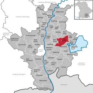
| Location of the Bad Endorf market in the Rosenheim district | ||
  |
||


Bad Endorf (until 1987 officially: Endorf i.OB ) is a market in the Upper Bavarian district of Rosenheim , which was officially recognized as a spa in 1987 . Since 1988 the place has had the designation "Bad" in the place name.
geography
Geographical location
The market is located around 15 km northeast of Rosenheim , 20 km south of Wasserburg am Inn , 30 km west of Traunstein , 8 km north of Prien am Chiemsee and 13 km from the Autobahn 8 (junction Bernau am Chiemsee ).
Community structure
There are 49 districts:

history
Until the church is planted
During the time of Roman rule (province of Noricum ) a Roman road led from Salzburg to Augsburg via what is now the municipality. In 924 the first documentary mention was made in the archives of the Archbishop of Salzburg with the spelling "Zennidorf". The district of Hirnsberg was first mentioned around 1100. For a long time, Endorf was an office of the Wildenwart rule , which together with the Hohenaschau rule was endowed with high jurisdiction . Endorf became an independent political municipality in the course of the administrative reforms in Bavaria after 1803.
19th and 20th centuries
In 1860 Endorf was connected to the Rosenheim – Salzburg line . In 1963, at a depth of 4848 m, the iodine-containing medicinal water was discovered by chance during an oil well . Then the construction of the spa began.
Incorporations
On April 1, 1971, parts of the dissolved community of Mauerkirchen were incorporated. On January 1, 1972, parts of Hirnsberg were added.
On August 19, 1973 Endorf was raised to the market. Hemhof and parts of the dissolved municipality of Pietzing were incorporated on May 1, 1978. In 1988, one year after being recognized as a spa , Endorf decided to use the name “bath” in the place name.
| local community | Date of incorporation | Districts |
|---|---|---|
| Hemhof | 05/01/1978 | Bach, Batterberg, Daumberg, Gaben, Hartmannsberg, Hemhof, Lemberg, Pelham, Rankham, Schlicht, Stephanskirchen and Thal |
| Hirnsberg | 01/01/1972 | Achthal, Anger, Asbichl, Gries, Hirnsberg, Holzberg, Holzen, Kreuzbichl, Kronlohe, Letten, Moos, Rain, See (at the Simssee), Stauden, Thalkirchen, Ulperting and Unterachthal |
| Wall churches | 04/01/1971 | Answer, Mauerkirchen, Rachenthal and Ströbing |
Population development
Between 1988 and 2018 the market grew from 5,082 to 8,377 by 3,295 inhabitants or 64.8 percent - the highest percentage growth in the district in the period mentioned.
politics
Municipal council
20 voluntary councilors together with the full-time mayor make up the council:
| 2014 | 2008 | 2002 | |
|---|---|---|---|
| Total seats | 20th | 20th | 20th |
| CSU | 7th | 7th | 9 |
| SPD | 3 | 3 | 5 |
| ÜWG 1 | 3 | 6th | 3 |
| EFL 3 | 2 | 4th | 3 |
| ABE 2 | 3 | - | - |
| B'90 / The Greens | 2 | - | - |
mayor
| Term of office | 1st Mayor | 2nd Mayor |
| -2020 | Doris Laban (ABE) | Wolfgang Kirner (CSU) |
| since 2020 | Alois Loferer (CSU) |
Community partnerships
economy
traffic
Road traffic
13 kilometers away from the town of Bad Endorf is the connection point Bernau am Chiemsee the Bundesautobahn 8 . This can be reached via state road 2092, which also connects Bad Endorf with Prien am Chiemsee . The state road 2095 provides a fast connection to the city center of Rosenheim .
Rail transport
The Rosenheim – Salzburg and Bad Endorf – Obing railway lines run through the municipality of Bad Endorf . The Rosenheim-Salzburg railway is the timetable of Deutsche Bahn run as a course book route 951st The Bad Endorf (Oberbay) train station is also located here . The Bad Endorf – Obing railway line is only used by museum trains today. The trains of the museum railway also start at Bad Endorf (Oberbay) station. They then use the Bad Endorf airfield stop to continue their journey towards Obing.
On May 7, 1860, the Rosenheim – Salzburg line was opened and the Endorf station was built. There were two crossing tracks and a water house at Endorf station. The station was also of great importance for goods from the region that were loaded at the loading ramp and the goods shed . In addition to the Endorf station, the Bergham stop was opened when the line opened . This was also in the municipality of Bad Endorf. On October 15, 1908, a local railway from Endorf to Obing was opened, whereupon another bypass was built on which the local railway locomotives move . In 1963, a pushbutton interlocking went into operation in Bad Endorf train station . On May 26, 1968, the Deutsche Bundesbahn stopped passenger transport on the local railway to Obing and stopped freight transport on January 1, 1996. On July 1, 2006, the line was reopened as a museum railway by the Chiemgauer Lokalbahn . The station, known today as Bad Endorf (Oberbay) , has a through track and three platform tracks, which are located on a house platform with a tongue platform and on an outside platform . Today the station is served every hour by regional express trains on the route Munich - Grafing - Rosenheim - Bad Endorf - Prien am Chiemsee - Traunstein - Freilassing - Salzburg . In addition, three long-distance trains stop in Bad Endorf. The museum railway is only in operation in summer. The Bergham stop on the railway line from Rosenheim to Salzburg was closed.
Bus transport
The municipality is connected to the regional transport network of Upper Bavaria (RVO) by five bus routes (9414, 9425, 9427, 9510 and 9511) . There are bus connections in the direction of Rosenheim , Prien am Chiemsee , Halfing , Wasserburg am Inn , Schonstett , Rimsting , Höslwang , Prutting and Eggstätt .
air traffic
Two kilometers north of the town center is the Bad Endorf airfield , a special airfield for aircraft up to 2000 kg maximum take-off weight (MTOW).
Public facilities
Gesundheitswelt Chiemgau AG (abbr.GWC, holding since 1998, majority of shares owned by the market) with the subsidiaries:
- Chiemgau-Thermen : (1971 to 1998 Jod Thermalbad Endorf AG) with thermal baths, sauna world and other offers in the areas of beauty , wellness and sport .
- Simssee Klinik GmbH: Specialist hospital for orthopedics , psychosomatics and geriatrics .
- Thermenhotel Ströbinger Hof
- Chiemgau Health Academy
State institutions
The Federal Police Sports School Bad Endorf is the federal police's center of excellence for the winter sports of alpine skiing , Nordic combined , cross-country skiing , ski jumping , biathlon , speed skating , short track , bobsleigh , luge and skeleton . The training takes place in the so-called "Bad Endorfer Model", that is, the training as a police officer and in competitive sports takes place in parallel.
Educational institutions
There is a primary and secondary school in Bad Endorf, which between 500 and 600 students attend (as of 2015). She is responsible for students from the school association between Bad Endorf, Halfing , Höselwang and Söchtenau .
Culture and sights
Buildings

- Parish Church of St. James from 1857.
- Hartmannsberg Castle between Schloßsee and Langbürgner See.
tourism
- With the Simssee , Langbürgner See , Schloßsee , Pelhamer See and just under a dozen smaller lakes in the Eggstätt-Hemhofer Seenplatte nature reserve , Bad Endorf is one of the municipalities in Bavaria with the most lakes.
- Bad Endorf is the northern starting point of the “ Grenzlos ” long-distance hiking trail , which leads on two alternative routes to Kufstein or connects Chiemsee and Kaisergebirge .
- The long-distance hiking trail " Via Julia ", which follows the course of the former Roman road from Salzburg to Augsburg , leads through the district of Stephanskirchen through the municipality and the Eggstätt-Hemhofer lake district .
- Bad Endorf is on the route of the Benediktweg , a pilgrimage route that was opened in August 2005.
theatre
- The theater company Bad Endorf e. V., the third oldest theater in Bavaria, mostly performs religious plays
Architectural monuments
Personalities
- Erna Tillgner (1888–1971), author and sculptor
- Wolfgang Clemen (1909–1990) was an important Anglicist and made a special contribution to Shakespeare research. He is considered to be the new founder of the English Department at the University of Munich after the Second World War . The Universities of Birmingham (1964), Rouen (1967) and Uppsala (1977) have awarded him an honorary doctorate . He was appointed Commander of the Order of the British Empire in 1972; In 1981 he was elected to the order Pour le mérite for sciences and arts . He was also the bearer of the Bavarian Maximilian Order for Science and Art , the Bavarian Order of Merit and the Great Federal Cross of Merit with a Star .
- Hermann Frieb , born in Mauerkirchen, resistance fighter against National Socialism, executed in 1943
- Walter Kindermann (1936–2013) was mayor from 1984 to 2002. The honorary citizen of the market was awarded the Federal Cross of Merit on ribbon in 2007.
- Maria Stadler (1914–1994) was awarded the Bundesfilmband in Gold (Federal Film Prize, now the German Film Prize ) in 1988 for her special services to German cinema. The director Doris Dörrie has set a film-documentary monument to her, the “Kino Maria” , with her debut work “Whether it's storming or snowing” .
Web links
- Homepage
- Entry on the coat of arms of Bad Endorf in the database of the House of Bavarian History
Individual evidence
- ↑ "Data 2" sheet, Statistical Report A1200C 202041 Population of the municipalities, districts and administrative districts 1st quarter 2020 (population based on the 2011 census) ( help ).
- ^ Municipality of Bad Endorf: Mayor. Retrieved May 24, 2020 .
- ↑ Markt Bad Endorf in the local database of the Bavarian State Library Online . Bayerische Staatsbibliothek, accessed on October 3, 2018.
- ^ Wilhelm Volkert (ed.): Handbook of Bavarian offices, communities and courts 1799–1980 . CH Beck, Munich 1983, ISBN 3-406-09669-7 , p. 561 .
- ^ Federal Statistical Office (ed.): Historical municipality directory for the Federal Republic of Germany. Name, border and key number changes in municipalities, counties and administrative districts from May 27, 1970 to December 31, 1982 . W. Kohlhammer GmbH, Stuttgart / Mainz 1983, ISBN 3-17-003263-1 , p. 587 and 588 .
- ↑ a b c Local elections in Bavaria
- ^ Mayor of Bad Endorf
- ^ Citizens & Town Hall> Municipality> Town Hall> Mayor. Bad Endorf municipality, accessed on May 23, 2020 .
- ^ Armin Franzke, Josef Mauerer: 1860–2010: 150 years of the Rosenheim - Salzburg line . PB Service, Munich 2010, ISBN 978-3-9812639-2-3 .
- ^ Armin Franzke, Josef Mauerer: 1860–2010: 150 years of the Rosenheim - Salzburg line . PB Service, Munich 2010, ISBN 978-3-9812639-2-3 , p. 128-129 .
- ^ Bad Endorf (Oberbay) | Deutsche Bahn AG. (No longer available online.) Archived from the original on October 17, 2018 ; accessed on October 16, 2018 (German). Info: The archive link was inserted automatically and has not yet been checked. Please check the original and archive link according to the instructions and then remove this notice.
- ^ Armin Franzke, Josef Mauerer: 1860–2010: 150 years of the Rosenheim - Salzburg line . PB Service, Munich 2010, ISBN 978-3-9812639-2-3 , p. 130 .
- ↑ Route network of the RVO. (PDF; 130KB) Retrieved October 17, 2018 .
- ^ Elementary and Middle School Bad Endorf - History. Retrieved on October 16, 2018 (German).
- ^ Elementary and middle school Bad Endorf - school association. Retrieved on October 16, 2018 (German).
- ^ Theatergesellschaft Bad Endorf e. V. Retrieved October 16, 2018 .
- ↑ Erna Tillgner at the Johannes-Theodor-Thormaehlen Foundation

Albaching | Amerang | Aschau im Chiemgau | Babensham | Bad Aibling | Bad Endorf | Bad Feilnbach | Bernau am Chiemsee | Brannenburg | Breitbrunn am Chiemsee | Bruckmühl | Chiemsee | Edling | Eggstätt | Eiselfing | Feldkirchen-Westerham | Flintsbach am Inn | Frasdorf | Griesstätt | Großkarolinenfeld | Gstadt am Chiemsee | Halfing | Höslwang | Kiefersfelden | Kolbermoor | New building | Nussdorf am Inn | Oberaudorf | Pfaffing | Prien am Chiemsee | Prutting | Ramerberg | Raubling | Riedering | Rimsting | Rohrdorf | Rott am Inn | Samerberg | Schechen | Schonstett | Söchtenau | Soyen | Stephanskirchen | Tuntenhausen | Vogtareuth | Wasserburg am Inn
Unregulated areas in the district of Rosenheim
Rotter Forst-Nord |
Rotter Forst-Süd