
Montmaur (Aude)
| Montmaur | ||
|---|---|---|
.svg)
|
|
|
| region | Occitania | |
| Department | Aude | |
| Arrondissement | Carcassonne | |
| Canton | Le Bassin Chaurien | |
| Community association | Castelnaudary Lauragais Audois | |
| Coordinates | 43 ° 24 ' N , 1 ° 51' E | |
| height | 188-306 m | |
| surface | 12.61 km 2 | |
| Residents | 307 (January 1, 2017) | |
| Population density | 24 inhabitants / km 2 | |
| Post Code | 11320 | |
| INSEE code | 11252 | |

Montmaur is a French commune with 307 inhabitants (as of January 1, 2017) in the Aude department in the Occitanie region (before 2016: Languedoc-Roussillon ). It belongs to the Arrondissement of Carcassonne and the canton of Le Bassin Chaurien (until 2015: canton of Castelnaudary-Nord ). The inhabitants are called Montmaurais .
location
Montmaur is located about 39 kilometers southeast of Toulouse in the Lauragais . Neighboring municipalities of Montmaur are Mourvilles-Hautes in the north and northwest, Les Cassés in the north and northeast, Saint-Paulet in the east, Soupex and Airoux in the southeast, Montferrand in the south, Avignonet-Lauragais in the west and southwest and Rieumajou in the west.
The community is located on Via Tolosana , one of the four historic " Way of the Pilgrims of St. James in France ".
Population development
| year | 1962 | 1968 | 1975 | 1982 | 1990 | 1999 | 2006 | 2013 |
| Residents | 318 | 290 | 241 | 228 | 242 | 266 | 306 | 325 |
| Source: Cassini and INSEE | ||||||||
Attractions
- Saint-Baudile church, a historic monument since 1948
- Montmaur Castle, Monument historique since 1926
- Valès Castle

Saint-Baudile church
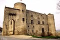
Montmaur Castle

Valès Castle


