Reichsstrasse 121
| Reichsstrasse 121 in the German Empire | |
| 121 | |
| Basic data | |
| Operator: |
|
| Start of the street: | Prochowice (Parchwitz) |
| End of street: | Mýtiny (knitting houses, OT from Harrachov) |
| Overall length: | 117 km |
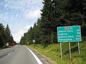
| The former Reichsstraße at today's Polish-Czech border crossing | |
The Reichsstraße 121 ( R 121 ) was a state road of the German Reich until 1945 , most of which lay in the province of Silesia . The road began at what was then Reichsstrasse 5 in Prochowice (Parchwitz), first ran on the route of today's Droga krajowa 94 to Legnica (Liegnitz), where Reichsstrasse 115 and Reichsstrasse 154 were crossed, and then via Złotoryja (Goldberg; Junction of Reichsstraße 155 ), Jelenia Góra (Hirschberg; junction with Reichsstraße 6 ) and further on the route of today's Droga krajowa 3 / European road 65 via Szklarska Poręba (Schreiberhau), crossed the border to former Czechoslovakia and ended at the group of houses Mýtiny ( Strickerhäuser, a district of Harrachov ) on what was then Reichsstrasse 150 .
Their total length was around 117 kilometers.
Individual evidence
- ^ The German Automobile Club (ed.): Road map of Germany, scale 1: 1,250,000, 1941
