
Rheinau (Baden)
| coat of arms | Germany map | |
|---|---|---|

|
Coordinates: 48 ° 40 ' N , 7 ° 56' E |
|
| Basic data | ||
| State : | Baden-Württemberg | |
| Administrative region : | Freiburg | |
| County : | Ortenau district | |
| Height : | 130 m above sea level NHN | |
| Area : | 73.51 km 2 | |
| Residents: | 11,395 (Dec. 31, 2018) | |
| Population density : | 155 inhabitants per km 2 | |
| Postal code : | 77866 | |
| Primaries : | 07844, 07227, 07853 | |
| License plate : | OG, BH , KEL, LR, WOL | |
| Community key : | 08 3 17 153 | |
| LOCODE : | DE RHI | |
City administration address : |
Rheinstrasse 52 77866 Rheinau |
|
| Website : | ||
| Mayor : | Michael Welsche | |
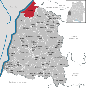
| Location of the city of Rheinau in the Ortenau district | ||
  |
||

Rheinau is a city in Baden-Württemberg and the northernmost of the Ortenau district . Freistett is the capital of the Rhine nearby municipality that the EUR district Strasbourg-Ortenau belongs.
The districts of Mannheim and Rastatt , the community-free area of Rheinau , which is about 45 km south-southwest (upstream), communities in neighboring Alsace ( France ) and in the canton of Zurich ( Switzerland ) have the same names .
geography
location
Rheinau lies in the Upper Rhine Plain . The urban area is located directly on the Rhine , in the middle of which the German-French border runs; the main town, Freistett, is 2.2 km from the Rhine, which flows there in a south-west-north-east direction. From the southernmost districts of Linx and Honau it is about 9 km to Kehl and 11 km (as the crow flies ) to Strasbourg in France . To the north of Honau and west-northwest of Diersheim lies the Steinwert-Hot 2 branch of the Altrhein .
The Glockenloch industrial area is located between Freistett and the Rheinau-Gambsheim dam to the north-west of it . It extends along the national road 87, which merges into the French D2 and leads over the barrage to France at Gambsheim there .
Neighboring communities
The city borders in the north on the city of Lichtenau in the Rastatt district , in the east on the city of Achern , in the southeast on the city of Renchen , in the south on the city of Kehl and in the west on the Alsatian communities of La Wantzenau , Gambsheim and Offendorf .
City structure

Politically, Rheinau is divided into the nine localities Freistett, Diersheim , Hausgereut , Helmlingen , Holzhausen , Honau, Linx, Memprechtshofen and Rheinbischofsheim . Apart from the main town of Freistett, where the town hall is located, a local council is elected in all parts of the city in accordance with the Baden-Württemberg municipal code and is chaired by a local mayor . The official naming of the districts is made by prefixing the name of the city and followed by the name of the respective district connected with a hyphen. In the localities there are administrative offices called “Stadt Rheinau, Ortsverwaltung ...”. The districts also form eight residential districts in accordance with the Baden-Württemberg municipal code, with the districts of Rheinbischofsheim and Hausgereut being combined into one residential district.
In terms of settlement geography, Rheinau also includes the nine villages and the much smaller hamlet of Hohbühn , which is administratively and parishly assigned to Linx. In the northeast of Rheinau is the Maiwaldsiedlung, which also extends to the boundaries of the neighboring towns of Achern and Renchen and is to be classified as a scattered settlement north of Memprechtshofen . On the barren, partly swampy soils of the former reindeer flood area , only homesteads could survive . Due to the population decimation during the Thirty Years' War , settlements in this less agriculturally less favored area were devastated.
In the urban area of Rheinau there are numerous lost localities : Ackerhof or Gaylingscher Hof, Guglingen and Hirsach were near Helmlingen; Quergen and Renchenloch near Memprechtshofen; Hohenhurst, Schufen und Stegen on Rheinbischofsheimer territory; Büche was near Holzhausen and Hastatt (?) In what is now Linx. The exact location of the deserted areas of Barau and Nulende is not known. Possible locations were identified on the districts of Freistett and Bodersweier or Querbach (districts of Kehl ).
Coats of arms of the districts

Linx (with high stage)


.svg)
.png)


history
The city of Rheinau came into being during the municipality reform in Baden-Württemberg .
Diersheim
In the district of Diersheim a fire burial ground of the Upper Rhine Ueben was found. It is the southernmost known cemetery in the Upper Rhine Valley. It contains 48 secured urns and some unsecured urns, 5 fire pit graves. The assignment to the Elbe Germanic Suebi results from the design of the accessories such as belt buckles, shield rim fittings, etc. In addition, a number of clay vessels have been identified as Elbe Germanic imports from Bohemia, Saxony and Thuringia.
The cemetery began to be occupied around 50 AD. Until 70 AD, the graves had rich grave goods of Elbe German origin, between 70 and 140 AD they were poor and have a provincial Roman character.
Helmets
After the Romans built a road that connected Argentorae ( Strasbourg ) with Aquaeum ( Baden-Baden ) (route like B36), a farm was established in the district of Helmlingen. Over time, this became a settlement that was probably burned down by the Teutons . The Suebian occupancy tore off. Between 140 and 260 AD, Elbe Germans reappear, but from the Altmark-East Hanoverian bowl urn group. With the fall of the Limes , the occupation of the burial ground ended.
Rheinbischofsheim
Rheinbischofsheim was first mentioned in a document in 1274 as a bishop's home . In 1574 the addition to the high footbridge was added. From 1803 the place was an office in the Landvogtei Yberg of the Grand Duchy of Baden , but lost this status to Kehl in 1815. In 1809 a Latin school was established here, the forerunner of today's grammar school.
Rheinau
The municipality of Memprechtshofen was incorporated into the municipality of Freistett on July 1, 1971 and the municipality of Helmlingen on October 1, 1974.
The community Hausgereut was incorporated into the community of Rheinbischofsheim on January 1, 1973, the Diersheim community on January 1, 1974, and the communities of Holzhausen and Linx on April 1, 1974.
On January 1, 1975, the city of Freistett-Rheinbischofsheim was formed by the union of the communities Freistett and Rheinbischofsheim. Honau joined them. The city was given the final name Rheinau after a previous public vote on the same day.
Before 1973, all communities belonged to the Kehl district .
politics

mayor
- 1975–1983: Friedrich Stephan
- 1983-2007: Meinhard Oberle (SPD)
- since 2007: Michael Welsche
Municipal council
The local elections on May 26, 2019 brought the following result with a turnout of 53.5% (2014: 56%):
coat of arms
The blazon of the coat of arms reads: "In gold with a red shield border a black lion."
Partnerships
The French neighboring town of Gambsheim has been an official partner municipality since June 22, 2019, based on municipal council resolutions.
Culture and sights
- Stadtkultur Rheinau: Events in the field of cabaret and the like in the town hall
- Heimatmuseum Rheinau e. V. in the district of Freistett
- Panzergraben cemetery and memorial in the Freistett district
- Jewish cemetery in the Freistett district
- Judenstein in the Rheinbischofsheim district
- Friedwald in the district of Memprechtshofen
- Historic bowling alley in the Holzhausen district
- Replica of a duck trap on a scale of 1:10 in the Memprechtshofen district
Buildings
- The Evangelical Church of Rheinbischofsheim is 56 m high and is the largest church in Hanauerland . It was built in 1876 and the interior was renovated in 1998.
- St. Nikolaus Chapel, called "Heidenkirchl", in the Freistett district. It is the oldest church in Hanauerland.
- St. Nicholas Church (often incorrectly called "St. Nicholas Chapel") in the Hausgereut district
- Diersheim town hall
- Fish ladder at the Rhine crossing , one of the largest fish ladders in Europe
- Until a few years ago, there was a 160 meter high meteorological measuring mast at 48 ° 40'33 "north latitude and 7 ° 55'14" east longitude . It was built because there were plans to build a nuclear power plant in Freistett.
Regular events
- There is a weekly market every Friday morning in Freistett on the market square.
- Dialect, culture and literature in the culture café and in the night café.
- Diersheim Winter: Events by artists and speakers from the region
- "Culture in the stable" (Freistett)
- Carnival in almost all parts of the city, every day between Dirty Thursday and Ash Wednesday in the “strongholds” of Rheinbischofsheim and Diersheim
Economy and Infrastructure
traffic
Bus transport
Rheinau is connected to Achern , Lichtenau (Baden) , Bühl (Baden) and Kehl by bus lines . The city belongs to the tariff association Ortenau . Due to its proximity to the Rastatt district and the agglomeration of Strasbourg , Rheinau is considered a transition area to the Karlsruhe Transport Association and the Stadtwerke of the Strasbourg city association and also benefits from special rates for bus trips to Lower Alsace.
Road traffic
Landstrasse 75 runs through the urban area. The motorway junctions Achern ( federal motorway 5 ) and Offendorf ( A35 ; Alsace motorway ) are 7 km away from Freistett . The County Road 5373 (of Diersheim according Auenheim), each spring of the "Narcissus Street". Hundreds of daffodils line the path to the left and right between the villages. Some bulb flowers, especially the tête-à-tête daffodils, were planted by private individuals.
Shipping
A shipyard and a marina are located near the barrage. In Helmlingen, Honau, Diersheim and Freistett, there are landing stages at the local gravel works for handling the excavated building materials.
air traffic
North of Rheinau, near the French border and the municipality of Rheinmünster - Söllingen in the Baden-Airpark is the Karlsruhe / Baden-Baden / FKB airport - sometimes also called "Baden-Airport" - from which flights to Berlin , Hamburg , Hurghada , London , Rome , Barcelona , Dublin , Marseille and Moscow as well as Pisa are offered.
education
Rheinau has numerous educational institutions:
- the Anne Frank grammar school with all-day school in the Rheinbischofsheim district
- the Rheinau secondary school in the Freistett district
- the Rheinau primary and secondary school with locations in the districts of Freistett and Rheinbischofsheim
- the elementary schools Rheinbischofsheim, Diersheim and Helmlingen
- two Protestant and seven municipal kindergartens
Established businesses
Important employers in the city include Brunner GmbH, Kieswerk HPF Hermann Peter KG Freistett, Klotter Elektrotechnik GmbH, RMA Pipeline Equipment, Stage Concept GmbH, Weber Fertighaus in Linx, Ytong Südwest GmbH ( Xella ), Zimmer Fruchtsaft and Zimmer Group in Freistett. Other companies are located in the Glockenloch industrial park .
The Centrale Electrique de Rhénane Gambsheim (CERGA), as operator of the barrage Rheinau-Gambsheim is a joint subsidiary of the French Electricite de France (EDF) and the German Energie Baden-Wuerttemberg AG (EnBW).
Club life
Sports
- Diersheim: SV Diersheim 1921 e. V.
- Freistett: SV Freistett 1921 e. V .; Turnerbund Freistett 1894 (over 1000 members).
- Helmlingen: TuS Helmlingen 1920 e. V.
- Honau: SV Honau 1948 e. V .; Karate-Dojo Rheinau e. V.
- Linx with Hobühn: SV Linx 1949; Fleet troop Linx
- Memprechtshofen: TuS Memprechtshofen 1921 e. V.
- Rheinbischofsheim with Hausgereut: VfR Rheinbischofsheim; TV Rheinbischofsheim 1896 e. V.
Making music, singing and dancing
- Diersheim: Musikverein Diersheim e. V .; Young wind instruments of the Musikverein Diersheim e. V .; Parforcehorn group Hanauerland - Diersheim department; Mixed choir Diersheim; Male Choir Singers Association Diersheim 1863 e. V .; Evangelical women's choir Diersheim; Dance group “Ma Navu” Diersheim; The Prince's Guards
- Freistett: Musikverein Stadtkapelle Freistett e. V .; Bläserjugend Musikverein Stadtkapelle Freistett e. V .; Fanfare procession of the Rheinau volunteer fire department Freistett; Workers' choir "Frohsinn" Freistett e. V .; Mixed choir 1899 Freistett e. V .; DO-RE-MI Children's and Youth Choir; Tanzgruppe Hanauerland e. V.
- Helmlingen: Singer Association Helmlingen e. V.
- Honau: Men's Choir Frohsinn Honau e. V.
- Linx with Hobühn: Musikverein "Harmonie" Linx e. V .; Mixed choir “Concordia” Linx e. V .; Mixed choir "Liederkranz" Holzhausen e. V.
- Memprechtshofen: Trombone Choir Memprechtshofen; Singers' Association Memprechtshofen 1887 e. V .; Tanzsportclub Memprechtshofen e. V.
- Rheinbischofsheim with Hausgereut: Rotkäppchen-Blech-Bänd eV; Fanfare procession Rheinbischofsheim; Musikverein "Frohsinn" Rheinbischofsheim e. V .; Bläserjugend Musikverein Frohsinn Rheinbischofheim e. V .; Men's choir "Liederkranz" Rheinbischofsheim e. V .; Evang. Church choir Rheinbischofsheim e. V.
Personalities
sons and daughters of the town

- Karl Ludwig Schulmeister (1770–1853), born in (Neu-) Freistett, spy in the service of Napoléon Bonaparte
- Georg König (1897–1976), born in Diersheim, farmer and politician (FDP / DVP), member of the state parliament
- Friedrich Stephan (1915–1997), born in Freistett, politician (SPD), member of the state parliament
Prominent residents
- Gottlob Schlörer (1891–1976), local researcher and natural scientist, lived temporarily in Diersheim, died in Bühl-Ottersweier
- Fred K. Prieberg (born June 3, 1928 in Berlin; † March 28, 2010 in Neuried-Ichenheim) German musicologist, lived in Diersheim for years.
- Hans Weber (* 1936) pioneer of prefabricated house construction, industrialist
- Gerhard (Gerard) Ruddies (born 1947) author, presenter (including “Halbneun”, “Take Third”, “Quite Schoen Schützen” for SWF) producer (sitcom: “Fascht e Familie” for SF DRS) and director (u. A. "Vis-à-Vis", "Report", "Wortwechsel" for SWR), lived 1979–1993 in Diersheim.
- Gerd Birsner (* 1953) songwriter, journalist and radio presenter; in his cabaret contributions as "Ortsrumsteher" (SWR 4) he exaggerated the village life in Diersheim
- Matto Barfuss (* 1970) cheetah man and artist
Persons connected to Rheinau
- Roland Wagner (* 1955), former French soccer player, played for SV Linx from 1990 to 1993
literature
- Rolf Nierhaus : Diersheim. In: Reallexikon der Germanischen Altertumskunde , Volume 5. Berlin 1984.
- Rolf Nierhaus: The Swebian burial ground of Diersheim. Studies on the history of the Teutons on the Upper Rhine from the Gallic War to the Alemannic conquest. Berlin 1966, ISBN 3-11-001205-7 .
- Nikolaus Honold, Kurt Schütt: Chronicle of the city of Rheinau. Ottersweier 1988.
Web links
Individual evidence
- ↑ State Statistical Office Baden-Württemberg - Population by nationality and gender on December 31, 2018 (CSV file) ( help on this ).
- ↑ Main statute of the city of Rheinau of November 12, 2001 ( page no longer available , search in web archives ) Info: The link was automatically marked as defective. Please check the link according to the instructions and then remove this notice.
- ^ The state of Baden-Württemberg. Official description by district and municipality. Volume VI: Freiburg administrative region. Kohlhammer, Stuttgart 1982, ISBN 3-17-007174-2 . Pp. 408-413.
- ^ R. Nierhaus: The Suebische burial ground of Diersheim. (= Roman-Germanic research, 28). 1966, p. 216 ff.
- ^ Website Rheinau - Stadtteile: Rheinbischofsheim , accessed on November 22, 2018
- ^ Federal Statistical Office (ed.): Historical municipality directory for the Federal Republic of Germany. Name, border and key number changes in municipalities, counties and administrative districts from May 27, 1970 to December 31, 1982 . W. Kohlhammer, Stuttgart / Mainz 1983, ISBN 3-17-003263-1 , p. 496 and 513 .
- ^ Federal Statistical Office (ed.): Historical municipality directory for the Federal Republic of Germany. Name, border and key number changes in municipalities, counties and administrative districts from May 27, 1970 to December 31, 1982 . W. Kohlhammer, Stuttgart / Mainz 1983, ISBN 3-17-003263-1 , p. 497 and 513 .
- ^ Federal Statistical Office (ed.): Historical municipality directory for the Federal Republic of Germany. Name, border and key number changes in municipalities, counties and administrative districts from May 27, 1970 to December 31, 1982 . W. Kohlhammer, Stuttgart / Mainz 1983, ISBN 3-17-003263-1 , p. 514 .
- ^ Ellen, Matzat: Rheinau and Gambsheim are looking forward to the signing of the town twinning . In: Kehler Zeitung . May 25, 2019.
- ↑ https://www.rheinau.de/soziales/schulen/
- ↑ leo-bw.de

Achern | Appenweier | Bad Peterstal-Griesbach | Berghaupten | Biberach | Durbach | Ettenheim | Fischerbach | Friesenheim | Gengenbach | Gutach (Black Forest Railway) | Haslach im Kinzigtal | Hausach | Hofstetten | Hohberg | Hornberg | Kappel-Grafenhausen | Kappelrodeck | Throat | Kippenheim | Lahr / Black Forest | Run | Lautenbach | Mahlberg | Meißenheim | Mühlenbach | Neuried | Nordrach | Oberharmersbach | Oberkirch | Oberwolfach | Offenburg | Ohlsbach | Oppenau | Ortenberg | Ottenhöfen in the Black Forest | Renchen | Rheinau | Ringsheim | Rust | Sasbach | Sasbachwalden | Schuttertal | Schutterwald | Schwanau | Seebach | Seelbach | Steinach | Willstätt | Wolfach | Zell am Harmersbach
Rheinau (municipality-free area)
Diersheim | Freett | House-paid | Helmlingen | Holzhausen | Honau | Linx | Memprechtshofen | Rheinbischofsheim