
Rivières (Charente)
| Rivières | ||
|---|---|---|
|
||
| region | Nouvelle-Aquitaine | |
| Department | Charente | |
| Arrondissement | Angoulême | |
| Canton | Val de Tardoire | |
| Community association | La Rochefoucauld-Porte du Périgord | |
| Coordinates | 45 ° 45 ′ N , 0 ° 22 ′ E | |
| height | 65–156 m | |
| surface | 21.54 km 2 | |
| Residents | 1999 (January 1, 2017) | |
| Population density | 93 inhabitants / km 2 | |
| Post Code | 16110 | |
| INSEE code | 16280 | |
 Rivières Town Hall |
||

Rivières ( Occitan : Riviera ) is a southwestern French municipality with 1999 inhabitants (as of January 1 2017) in the department of Charente in the region Nouvelle-Aquitaine . Rivières is located in the arrondissement of Angoulême and in the canton of Val de Tardoire (until 2015: canton of La Rochefoucauld ). The inhabitants are called Riviérois .
location
Rivières is located about 18 kilometers northeast of Angoulême on the Tardoire River in the cultural landscape of the Angoumois . The Bandiat also flows through the community . Rivières is surrounded by the neighboring communities
- Agris in the north and north-west,
- Les Pins in the north,
- Taponnat-Fleurignac in the east and northeast,
- La Rochefoucauld-en-Angoumois with La Rochefoucauld in the south and south-east and Saint-Projet-Saint-Constant in the south,
- Brie to the west and southwest.
The National Route 141 runs through the municipality .
Population development
| year | 1962 | 1968 | 1975 | 1982 | 1990 | 1999 | 2006 | 2012 |
| Residents | 1,050 | 1.106 | 1,212 | 1,484 | 1,587 | 1,737 | 1,894 | 1,882 |
| Source: Cassini and INSEE | ||||||||
Attractions
- Romanesque church of Saint-Cybard from the 12th century, rebuilt in the 15th century, monument historique since 1948
- Ribérolles mansion, Monument historique since 2010
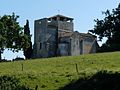
Saint-Cybard Church

Riberolles mansion


Web links
Commons : Rivières - Collection of images, videos and audio files