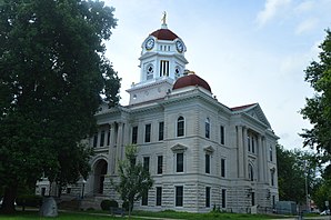
Hancock County, Illinois
 Hancock County Courthouse |
|
| administration | |
|---|---|
| US state : | Illinois |
| Administrative headquarters : | Carthage |
| Address of the administrative headquarters: |
County Courthouse 500 Main Street Carthage, IL 62321-0000 |
| Foundation : | January 13, 1825 |
| Made up from: | Pike County |
| Area code : | 001 217 |
| Demographics | |
| Residents : | 19,104 (2010) |
| Population density : | 9.3 inhabitants / km 2 |
| geography | |
| Total area : | 2110 km² |
| Water surface : | 52 km² |
| map | |
| Website : www.hancockcountycourthouse.org | |
The Hancock County is a county in the US -amerikanischen State Illinois . In 2010 , the county had 19,104 residents and a population density of 9.3 people per square kilometer. The county seat is Carthage .
geography
The county is located in western Illinois on the Mississippi River , which forms the border with the neighboring states of Iowa and Missouri . Hancock County covers an area of 2,110 square kilometers, of which 52 square kilometers are water. It borders on the following neighboring counties:
|
Lee County, Iowa |
Henderson County | |
|
Clark County, Missouri |

|
McDonough County |
|
Lewis County, Missouri |
Adams County | Schuyler County |
history
Hancock County was formed in the Illinois Territory on January 13, 1825, adjacent to Pike County, and named after John Hancock , a member of Congress and governor of Massachusetts .
The first courthouse was built in Montebello , on the banks of the Mississippi River . In 1833 the administrative headquarters were moved to Carthage. The courthouse, which still exists today, was built in 1908. Mormons also settled in Nauvoo around 1839 . From 1839 to 1846, Nauvoo was the largest city in Illinois.
In 1844, Mormon leader Joseph Smith and his brother Hyrum Smith were murdered by an angry mob in Carthage Prison. The Nauvoo Exodus began in early 1846 when the Mormons moved to their new headquarters in Utah .
Demographic data
| Population development | |||
|---|---|---|---|
| Census | Residents | ± in% | |
| 1840 | 483 | - | |
| 1850 | 9946 | 1,959.2% | |
| 1860 | 14,652 | 47.3% | |
| 1870 | 29.001 | 97.9% | |
| 1880 | 35,035 | 20.8% | |
| 1890 | 31,907 | -8.9% | |
| 1900 | 32,215 | 1 % | |
| 1910 | 30,638 | -4.9% | |
| 1920 | 28,523 | -6.9% | |
| 1930 | 26,420 | -7.4% | |
| 1940 | 26,297 | -0.5% | |
| 1950 | 25,790 | -1.9% | |
| 1960 | 24,574 | -4.7% | |
| 1970 | 23,645 | -3.8% | |
| 1980 | 23,877 | 1 % | |
| 1990 | 21,373 | -10.5% | |
| 2000 | 20.121 | -5.9% | |
| 2010 | 19,104 | -5.1% | |
| Before 1900 1900–1990 2000 2010 | |||
As of the 2010 census , there were 19,104 people in 8,024 households in Hancock County. The population density was 9.3 people per square kilometer. Statistically, 2.31 people lived in the 8,024 households.
The racial the population was composed of 98.0 percent white, 0.3 percent African American, 0.2 percent Native American, 0.2 percent Asian and other ethnic groups; 0.9 percent were descended from two or more races. Hispanic or Latino of any race was 1.0 percent of the population.
22.0 percent of the population were under 18 years old, 68.2 percent were between 18 and 64 and 19.8 percent were 65 years or older. 50.8 percent of the population was female.
The median income for a household was 43,774 USD . The per capita income was $ 23,098. 11.6 percent of the population lived below the poverty line.
Localities in Hancock County
1 - partly in Henderson County
2 - partly in Adams County
structure
Hancock County is divided into 25 townships :
|
|
See also
Individual evidence
- ↑ GNIS-ID: 424235. Retrieved on February 22, 2011 (English).
- ↑ a b c U.S. Census Bureau, State & County QuickFacts - Hancock County, IL ( Memento of the original from July 11, 2011 on WebCite ) Info: The archive link was automatically inserted and has not yet been checked. Please check the original and archive link according to the instructions and then remove this notice. Retrieved December 6, 2012
- ^ A b National Association of Counties.Retrieved December 6, 2012
- ^ US Census Bureau - Census of Population and Housing.Retrieved March 15, 2011
- ^ Extract from Census.gov.Retrieved February 15, 2011
- ↑ Missouri Census Data Center - Illinois ( page no longer available , search in web archives ) Info: The link was automatically marked as defective. Please check the link according to the instructions and then remove this notice. Retrieved December 6, 2012
Web links
Coordinates: 40 ° 24 ′ N , 91 ° 10 ′ W

