
District of Jerichower Land
| coat of arms | Germany map |
|---|---|

|

Coordinates: 52 ° 16 ' N , 12 ° 2' E |
| Basic data | |
| Existing period: | 2007– |
| State : | Saxony-Anhalt |
| Administrative headquarters : | Castle |
| Area : | 1,576.84 km 2 |
| Residents: | 89,589 (Dec. 31, 2019) |
| Population density : | 57 inhabitants per km 2 |
| License plate : | JL, BRG, GNT |
| Circle key : | 15 0 86 |
| NUTS : | DEE06 |
| Circle structure: | 8 municipalities |
| Address of the district administration: |
Bahnhofstrasse 9 39288 Burg |
| Website : | |
| District Administrator : | Steffen Burchhardt ( SPD ) |
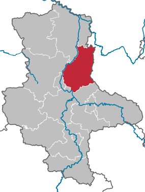
| Location of the district of Jerichower Land in Saxony-Anhalt | |
  |
|
The district of Jerichower Land is a district in the northeast of the state of Saxony-Anhalt . Neighboring districts are in the northwest and the north of the district of Stendal , in the northeastern Brandenburg Havelland , to the east which also Brandenburg Potsdam-Mittelmark , south of Anhalt-Bitterfeld , in the southwest of Salzlandkreis and the independent city of Magdeburg and in the west of the district Börde .
geography

The most important bodies of water in the district of Jerichower Land are - besides the Elbe - the Elbe-Havel Canal , the Mittelland Canal , the Ehle , the Nuthe , the Ihle and the Tucheim-Parchener Bach. The district has shares in the Fläming and Karower Platte plateaus formed during the Ice Age . The highest point is at 127 m above sea level. NHN of Jerusalem .
In the far east are five enclaves belonging to the Brandenburg district of Potsdam-Mittelmark in the area of the city of Möckern . There is also an exclave of the Jerichower Land district in the town of Ziesar in Potsdam-Mittelmark.
history
The district was first created in 1994 through the merger of the Burg and Genthin districts and the Mangelsdorf community in the Havelberg district . He continued the tradition of the old Prussian districts Jerichow I and Jerichow II . As a district town, Burg prevailed against Genthin in a referendum .
During the district reform of Saxony-Anhalt in 2007 , this district was dissolved and a new, larger district with the same name was formed. The south of the new district consists of communities that previously belonged to the Anhalt-Zerbst district , but had previously belonged to the old Jerichow I district.
politics
District council
district council Jerichower Land 2019
- Left : 6
- Greens : 3
- SPD : 8
- FDP : 2
- FWG Endert JL : 1
- FWG-J : 3
- Flat share Fläming : 2
- LWG : 1
- CDU : 10
- AfD : 6
(Result of the local elections on May 26, 2019)
| Parties and constituencies | Percent 2019 |
Seats 2019 |
Percent 2014 |
Seats 2014 |
Percent 2007 |
Seats 2007 |
Percent 2004 |
Seats 2004 |
Percent 1999 |
Seats 1999 |
Percent 1994 |
|
|---|---|---|---|---|---|---|---|---|---|---|---|---|
| CDU | Christian Democratic Union of Germany | 24.2 | 10 | 34.1 | 14th | 29.8 | 14th | 37.0 | 16 | 38.2 | 18th | 29.8 |
| SPD | Social Democratic Party of Germany | 18.3 | 8th | 21.2 | 9 | 25.5 | 12 | 22.7 | 10 | 27.0 | 13 | 35.7 |
| AfD | Alternative for Germany | 14.6 | 6th | - | - | - | - | - | - | - | - | - |
| THE LEFT. | THE LEFT. | 14.2 | 6th | 17.5 | 7th | 15.8 | 8th | 18.8 | 8th | 16.1 | 8th | 16.0 |
| GREEN | Alliance 90 / The Greens | 7.0 | 3 | 5.5 | 2 | 2.9 | 2 | 3.0 | 1 | 2.3 | 1 | 4.9 |
| FDP | Free Democratic Party | 6.3 | 2 | 4.6 | 2 | 6.5 | 3 | 8.4 | 3 | 7.9 | 4th | 7.3 |
| FWG-J | Free community of voters Jerichow | 6.0 | 3 | 4.4 | 2 | 2.5 | 1 | 1.7 | 1 | - | - | - |
| Fläming flat share | Fläming community of voters | 4.9 | 2 | 1.3 | 1 | - | - | - | - | - | - | - |
| LWG | Rural voter community Jerichower Land | 2.7 | 1 | 2.5 | 1 | 2.6 | 1 | 4.2 | 2 | 4.0 | 2 | 3.9 |
| FWG Endert JL | Free voter community / Endert Jerichower Land | 1.8 | 1 | 4.9 | 2 | 3.6 | 2 | - | - | - | - | - |
| FW | FREE VOTERS | - | - | 4.0 | 2 | - | - | - | - | - | - | - |
| Active JL | Active for the Jerichower Land | - | - | - | - | 4.6 | 2 | - | - | - | - | - |
| NPD | National Democratic Party of Germany | - | - | - | - | 2.3 | 1 | - | - | - | - | - |
| FWG | Free voter community Burg | - | - | - | - | 1.6 | 1 | 2.9 | 1 | 1.5 | 1 | - |
| education | Initiative school education with a future Jerichower Land | - | - | - | - | 1.6 | 1 | - | - | - | - | - |
| WASG | Elective alternative work and social justice | - | - | - | - | 0.6 | - | - | - | - | - | - |
| NEW FORUM | New forum | - | - | - | - | - | - | - | - | 1.7 | 1 | 2.1 |
| WG AWV | General voter association Genthin eV | - | - | - | - | - | - | - | - | 0.8 | - | - |
| EB | Individual applicants | - | - | - | - | - | - | 1.1 | - | 0.5 | - | - |
| Others | Others | - | - | - | - | - | - | - | - | - | - | 0.3 |
| total | 100 | 42 | 100 | 42 | 100 | 48 | 100 | 42 | 100 | 48 | 100 | |
| Turnout in percent | 54.2 | 48.1 | 36.3 | 42.8 | 49.5 | 67.4 | ||||||
- The Left took up the position of PDS until 2004 .
- EB: Individual applicant 2004: Frank Endert; 1999: Roland Richter (0.2%), Wolfgang Schulze (0.3%).
- The results of the 1994 to 2004 elections relate to the territorial status before 2007.
- There is no distribution of seats for the 1994 election.
The distribution of seats among the parliamentary groups in the district assembly after the election on May 26, 2019:
- CDU : 10 members
- SPD / FDP : 10 members
- AfD / FWG Endert JL: 7 members
- LEFT : 6 members
- Voting communities Jerichower Land (incl. FWG-J, WG Fläming, LWG): 6 members
- GREEN : 3 members
The chairman of the district council is Matthias Fickel (CDU), the first deputy is Helmut Halupka (SPD) and the second deputy is Michael Bremer (Die Linke).
The SPD politician Steffen Burchhardt has been the district administrator since 2014 .
From 1994 to 2001 Detlev Lehmann (SPD) held the office of district administrator. In 2001, Lothar Finzelberg was elected as the first PDS district administrator. He resigned from the PDS in 2003, was re-elected in 2007 and remained district administrator until 2014.
coat of arms
The coat of arms of the Altlandkreis of the same name was approved on September 12, 1995 by the Ministry of the Interior of Saxony-Anhalt. Since the district was formally dissolved and re-established on July 1, 2007, the coat of arms had to be approved again, on February 5, 2008.
Blazon : "Split by blue and silver, in front a silver pole, behind a black, silver-contoured and red- armored crane ."
Colors of the county are white and blue.
The silver post symbolizes the Elbe-Havel Canal as an important waterway in the Jerichower Land and at the same time indicates the Elbe as the western boundary of the district. The crane, which lives in the district, populates the Elbe meadows every year and thus represents a symbol of landscape and nature.
The coats of arms of the administrative communities, cities and municipalities of the district can be found in the list of coats of arms in the district of Jerichower Land .
flag
The flag was approved on April 3, 2008 by the Ministry of the Interior of Saxony-Anhalt.
The flag is white-blue (1: 1) striped (cross shape: stripes running horizontally, lengthways shape: stripes running vertically) and centered with the district coat of arms.
economy
The Jerichower Land is today one of the economically strongest districts in Saxony-Anhalt, alongside the Saalekreis and the Börde district . On the one hand, the district benefits from its proximity to Magdeburg. On the other hand, a steadily growing economy has developed particularly in the Burg area .
The focal points are:
- Food industry (e.g. Burger Knäcke , Wiesenhof )
- Steel processing (e.g. Burger rolling mill )
- Paper industry ( e.g. Prowell , Propapier )
- Furniture industry (e.g. burger kitchens )
traffic
The district town of Burg was - like Genthin - connected to the long-distance railway network as early as 1846 with the construction of the Berlin-Magdeburg railway line by the Berlin-Potsdam-Magdeburg Railway Company . This company also opened the Biederitz – Trebnitz railway line in 1874 , which merged with the older one in Biederitz.
The first branch line was built by the Prussian State Railways in 1892 and ran from Biederitz via Möckern to Loburg . There it was connected to the extensive narrow-gauge network of the small railways of the Jerichow I district , which in 1896 led from the district town of Burg on two parallel routes that merged in Magdeburgerforth to Ziesar. The connection Groß Lübars – Loburg – Gommern followed in 1903. Because of the military training area in Altengrabow , the route to the state railway to Loburg was expanded as a three - rail track .
In Ziesar - now part of the state of Brandenburg - the narrow-gauge railways were joined by the standard-gauge small railway network of Genthiner Eisenbahn AG , which has grown together from several independent companies. The following sections relate to the Jerichower Land district (with the opening year):
- 1899 Genthin – Schönhausen railway and Genthin – Milow railway
- 1912 Railway line Rogäsen – Karow
- 1917 Güsen – Ziesar railway line
- 1924 Güsen – Jerichow
This meant that there were railway lines with a length of around 260 kilometers in today's district; of which over 160 kilometers have now been shut down for passenger traffic:
| year | route | Gauge | length |
|---|---|---|---|
| 1951 | Rogäsen – Karow | 1435 mm | 2 km |
| 1960 | Loburg – Kressow – Gommern | 750 mm | 7 km |
| Klb Castle - Magdeburgerforth - Ziesar East | 750 mm | 34 km | |
| 1965 | Zerbster Tor Castle - Großlübars | 750 mm | 28 km |
| Altengrabow – Magdeburgerforth Bf | 750 mm | 6 km | |
| 1967 | Genthin – Kuxwinkel – Milow | 1435 mm | 16 km |
| Loburg – Lübars – Altengrabow | 1435 mm | 7 km | |
| 1999 | Güsen-Jerichow | 1435 mm | 21 km |
| 1999 | Güsen – Paplitz – Ziesar | 1435 mm | 23 km |
| Genthin Klb-Jerichow-Schönhausen-Sandau | 1435 mm | 20 km |
The Kleinbahn und Kraftwerk Pretzien GmbH was a narrow-gauge railway that only served goods traffic.
The BAB 2 and the federal highways 1 , 107 , 184 , 246 and 246a also run through the Jerichower Land .
The district of Jerichower Land has the vehicle registration number JL. In addition, the old license plates BRG and GNT have been available again since 2012.
Communities


Unified municipalities
(cities arehighlighted in bold )
(* seat of the district)
| coat of arms | local community | Residents | Area in km² |
|---|---|---|---|
|
|
Biederitz | 8497 | 39.33 |
|
|
Castle * | 22.406 | 164.05 |
|
|
Elbe parey | 6416 | 108.65 |
|
|
Genthin | 13,761 | 230.73 |
|
|
Gommern | 10,488 | 159.98 |
|
|
Jerichow | 6773 | 269.93 |
|
|
Moan | 12,930 | 523.93 |
|
|
Möser | 8318 | 80.24 |
Territorial changes
Since 1995 there have been many changes in the area in the Jerichower Land district.
There are no longer any of the original ten administrative communities. In the same time the number of parishes decreased to eight.
Changes in administrative communities
- Dissolution of the Elbe-Parey administrative community - formation of the Elbe-Parey single community from the member communities (September 1, 2001)
- (Provisional) dissolution of the administrative community Genthin - incorporation of the member communities into the city of Genthin , which (for the time being) becomes a unified community (April 30, 2002)
- Dissolution of the administrative community Burg - incorporation of the member communities into the city of Burg (December 1, 2002)
- Formation of the Möckern-Fläming administrative community from the Möckern and Fläming-Fiener administrative communities (excluding the communities of Gladau , Paplitz and Tucheim ) (January 1, 2005)
- (Re) formation of VG Genthin from the communities of Gladau, Paplitz and Tucheim of the dissolved VG Fläming-Fiener (January 1, 2005)
- Formation of the Elbe-Stremme-Fiener administrative community from the Jerichow and Stremme-Nordfiener administrative communities (January 1, 2005)
- Formation of the administrative community Biederitz-Möser from the administrative communities Biederitz (excluding the communities Menz , Nedlitz and Wahlitz ) and Möser (January 1, 2005)
- Dissolution of the administrative community Gommern - formation of the city of Gommern from the member communities and the communities Menz, Nedlitz and Wahlitz from the dissolved VG Biederitz and the communities Dornburg, Ladeburg and Leitzkau from the district of Anhalt-Zerbst (January 1, 2005)
- Dissolution of VG Genthin - incorporation of the member parishes into the city of Genthin, which becomes a unified parish (July 1, 2009)
- Dissolution of the Elbe-Stremme-Fiener administrative association (January 1, 2010)
- Dissolution of the administrative association Biederitz-Möser (January 1, 2010)
- Dissolution of the Möckern-Loburg-Fläming administrative community (September 1, 2010)
Changes at the community level
Church planting
- Dissolution of the municipalities City of Jerichow , Brettin , Demsin , Kade , Karow , Klitsche , Nielebock , Redekin , Roßdorf , Schlagenthin , Wulkow and Zabakuck - re-establishment of the city of Jerichow (January 1, 2010)
- Dissolution of the municipalities of Biederitz , Gerwisch , Gübs , Königsborn and Woltersdorf - re-establishment of the municipality of Biederitz (January 1, 2010)
- Dissolution of the communities Hohenwarthe , Körbelitz , Lostau , Möser , Pietzpuhl and Schermen - re-establishment of the community Möser (January 1, 2010)
Incorporations
- Dissolution of the community of Friedensau , Stegelitz and Wörmlitz - incorporation into Möckern (January 1, 2002)
- Dissolution of the community of Ihleburg - incorporation into Burg (May 25, 2002)
- Dissolution of the Lübars community - incorporation into Möckern (July 1, 2002)
- Dissolution of the Mangelsdorf community - incorporation into Jerichow (August 6, 2002)
- Dissolution of the municipalities of Büden and Ziepel - incorporation into Möckern (January 1, 2003)
- Dissolution of the municipality of Hohenziatz - incorporation into Möckern (January 1, 2004)
- Dissolution of the municipality of Mützel - incorporation into Genthin (March 1, 2004)
- Dissolution of the municipality of Reesen - incorporation into Burg (July 1, 2009)
- Dissolution of the municipality of Loburg - incorporation into Möckern (January 1, 2009)
- Dissolution of the municipalities of Magdeburgerforth and Reesdorf - incorporation into Möckern (July 1, 2009)
- Dissolution of the communities of Drewitz , Grabow , Krüssau , Rietzel and Wüstenjerichow - incorporation into Möckern (January 1, 2010)
- Dissolution of the Stresow community - incorporation into Möckern (September 1, 2010)
- Dissolution of the community of Schopsdorf - incorporation into Genthin (July 1, 2012)
Protected areas
There are nine designated nature reserves in the district (as of February 2017).
License Plate
On July 1, 1994, the district was assigned the distinctive sign JL . It is still issued today.
Until around the year 2000, vehicles from the areas of the former Burg and Genthin districts were each given special identification numbers:
| area | Letters | numbers |
|---|---|---|
| Altkreis Castle | A to N | 1 to 999 |
| AA to NZ | 1 to 99 | |
| Genthin old district | P to Z | 1 to 999 |
| PA to ZZ | 1 to 99 |
Since November 29, 2012, the distinctive signs BRG (formerly Burg) and GNT (former Genthin) have been available.
Web links
Individual evidence
- ↑ State Statistical Office Saxony-Anhalt, population of the municipalities - as of December 31, 2019 (PDF) (update) ( help ).
- ↑ census database
- ↑ Map services of the Federal Agency for Nature Conservation ( information )
- ↑ https://wahlresults.sachsen-anhalt.de/wahlen/kw19/erg/kreis/kw.15086.ergtab.frametab.html
- ^ Result of the district election 2014 ( Memento from March 4, 2016 in the Internet Archive )
- ^ Result of the district election 2007 ( Memento from September 8, 2014 in the Internet Archive )
- ^ Result of the district council election 2004
- ↑ Results of the district elections in 1994 and 1999 ( Memento from September 8, 2014 in the Internet Archive )
- ↑ a b State Administration Office of Saxony-Anhalt (Ed.): Official Journal . 5th year, no. 8 . Halle (Saale) May 15, 2008, p. 137 f . ( lvwa.sachsen-anhalt.de ( Memento from December 8, 2015 in the Internet Archive ) [PDF; 235 kB ; accessed on December 1, 2015]). Official Journal ( Memento of December 8, 2015 in the Internet Archive )
- ↑ State Statistical Office Saxony-Anhalt, population of the municipalities - as of December 31, 2019 (PDF) (update) ( help ).
- ↑ regionalstatistik.de Regional database of the Federal Statistical Office (as of December 31, 2016)
Altmarkkreis Salzwedel | Anhalt-Bitterfeld | Börde | Burgenland District | Dessau-Roßlau | Halle (Saale) | Resin | Jerichower Land | Magdeburg | Mansfeld-Südharz | Saalekreis | Salzlandkreis | Stendal | Wittenberg
Detlev Lehmann (1994-2001) | Lothar Finzelberg (2001–2014) | Steffen Burchhardt (since 2014)