
Rupertiwinkel


The Rupertiwinkel (also: Bayerischer Rupertiwinkel ; sometimes incorrectly called Rupertigau ) has been classified by the Bavarian State Office for the Environment since 2011 and 2013 as a cultural landscape unit with two significant cultural landscapes , which are located in the extreme southeast of Upper Bavaria (in a north-south direction) over parts of the Districts Altötting , Traunstein and Berchtesgadener Land .
Geographically, this region is shaped by the two larger still waters Waginger See and Tachinger See and the Högl as a prominent elevation. I.a. the Aperschnalzen has to this day as the Salzburg Flachgau receive common, regional peculiarity-preserving custom.
The Rupertiwinkel belonged to the outskirts of the Prince Archbishopric of Salzburg until 1803 without its own area or region designation . In 1810 the entire territory of this principality became part of the Kingdom of Bavaria . Unlike the rest of the former Salzburg territory, the Rupertiwinkel region remained with Bavaria with the Treaty of Munich in 1816. The area designation "Rupertiwinkel" was only mentioned in writing during the homeland movement at the end of the 19th and beginning of the 20th century and has since referred to a landscape with its own historical and cultural roots and corresponding customs. This area designation was preceded by the liturgical privilege granted by Salzburg to the separated Roman Catholic parishes of the region in 1814 to celebrate the holiday of the Salzburg patron saint Rupert of Salzburg again, albeit limited to the celebration of mass.
geography
Geographical location
The Rupertiwinkel area around Waginger See and Tachinger See lies north of the Chiemgau Alps and borders the Austrian city of Salzburg in the east .
The geographic extent of the Ruperti angle thus extends (sorted clockwise ):
- in the north from the Alz past Trostberg and over Tyrlaching to Asten ,
- in the east of Asten along the Salzach via Tittmoning , past Fridolfing , via Laufen and Surheim to Freilassing ,
- in the southeast of Freilassing, along the Saalach via Ainring to Piding ,
- in the south of Piding over the ridge of the Hochstaufen and the Teisenberg near Anger and past Teisendorf to the Teisendorfer district of Neukirchen and
- in the west of Neukirchen via Waging am See , Otting and Palling back to Trostberg an der Alz .
Rupertiwinkel cultural landscape unit
As part of the cultural landscape structure of Bavaria as a contribution to biodiversity , the Rupertiwinkel was set up in a draft of the Bavarian State Office for the Environment from 2011 under the designation "60 Rupertiwinkel" as a separate cultural landscape unit, which is consciously based on the demarcation of former areas of the Archdiocese of Salzburg with the Chiemgau oriented in the west, the Alz -Hügelland in the north and the Berchtesgadener Land in the south. In the east, the Rupertiwinkel extends to the Austrian border, which in this section follows the course of the Saalach or the Salzach and, among other things, is a. as a "diverse hill country" in front of the Berchtesgaden and Salzburg Alps .
Within this cultural landscape unit, two significant cultural landscapes in the sense of "cultural landscape recommendations for Bavaria" were defined in 2012 and 2013 :
- 60-A: Salzachtal between Laufen and Burghausen
- 60-B: Rupertiwinkel around the Waginger and Tachinger See
mountains
The mountains and elevations in the Ruperti angle include - sorted by height in meters (m) above sea level (NN):
- Hochstaufen (1771 m) near Piding .
- Teisenberg (1333 m) near Teisendorf .
- Högl ( 827 m ) between Anger and Ainring - Thundorf
- Hochhornberg ( 774 m ), near Teisendorf
- Schlossberg von Tettelham (559 m) near Otting, municipality of Waging
- Rainbichl (544 m) near Tyrlaching , (excellent view over the entire Rupertiwinkel)
- Eichelberg ( 532 m ), near Oberbuch in Tyrlaching
- Wölfelsberg ( 463 m ), near Schönram in Petting
- Beselberg (461 m), in the urban area of Laufen on the B 20 in the direction of Tittmoning
- Brack ( 450 m ), near Patting in Teisendorf

Hochstaufen of Bayerisch Gmain from
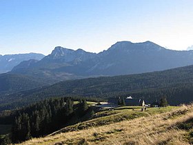
Teisenberg with a view from the Schneid to the Stoißer Alm


Waters
- Rivers
- Salzach (225 km; source in the state of Salzburg )
- Saalach (103 km; source in the province of Salzburg)
- Sur (43 km; source in Surberg im Chiemgau )
- Götzinger Ache (31 km; source Waginger See )
- Lakes
- Waginger See (6.61 km²)
- Tachinger See (2.36 km²)
- Abtsdorfer See (84 ha)
- Leitgeringer See (15 ha)
- Höglwörther See (13.5 ha)
- Fridolfinger See (5 ha)

Waginger See with Hochstaufen , Zwiesel in front of the flatter Teisenberg
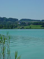
Taching and Tachinger See


history
prehistory
Within the Bavarian tribal and territorial duchy
Originally (from the 6th century) the area of the later Rupertiwinkel belonged to what was then Salzburggau and was part of the Bavarian tribal duchy . The Salzburg Church already owned scattered properties in the area at an early stage. For example, the Bavarian Duke Theodo handed over the village of Piding with 30 farms to the first Salzburg Bishop Rupert around the year 700 .
During the first decades of the Bavarian territorial duchy (1180-1918) and after the Counts of Lebenau had died out in 1229, the Archbishop of Salzburg, Eberhard II , was able to secure their territory (including the northern half of the later Rupertiwinkel north and east of Lake Waginger). With the extinction of the Counts of Plain in 1260, u. a. also the southern half of the later Rupertiwinkel south and west of the Waginger See to the diocese of Salzburg . These areas were u. a. Also part of the agreements signed by Erharting in 1254 and 1275 , with which the prerequisites for the state separation from the Duchy of Bavaria and the recognition of the Archdiocese of Salzburg as an independent territory were created.
In the outskirts of the independent Prince Archdiocese of Salzburg
With the enactment of a separate state order by Archbishop Friedrich III. Leibnitz was Archbishopric of Salzburg from 1328 to a largely autonomous territory within the Holy Roman Empire . The later “Rupertiwinkel” was assigned to the “granary” of the archbishopric because of its fertile soil and its area was assigned to the outlying mountains or “Land vor dem Gebirg” or “Flaches Land” called northern Salzburg possessions. In terms of area, it largely coincided with the former Salzburg nursing courts Staufeneck , Raschenberg- Teisendorf, Halmberg- Waging, Tittmoning and Laufen .

Oil painting: St. Rupert of Salzburg, namesake of the Rupertiwinkel

Dominions in northern Salzburggau in the High Middle Ages
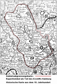
Map of the Archbishopric Salzburg (18th century)

Information board on the historical border between Salzburg and Bavaria


Secularization and transition to the Kingdom of Bavaria
Changing rulers (1803-1810)
In the course of secularization , Hieronymus Graf Colloredo abdicated in 1803 as the last Prince Archbishop of Salzburg. After that, the former Grand Duke of Tuscany Ferdinand III took over. the reign as Elector of Salzburg . After the Peace of Pressburg in 1805, the Salzburg region was under the rule of the Austrian Empire from 1806 to 1809 , then for almost a year that of Napoleonic France . In the Treaty of Schönbrunn , it was assigned to the Kingdom of Bavaria, just like the area of the former prince-provost of Berchtesgaden, which from 1803 was also under similarly changing reigns . In its implementation, it became part of the Salzach district in the Kingdom of Bavaria in 1810 .
Division of the former Salzburg out-of-the-mountain possessions
After the negotiations at the Congress of Vienna under the direction of Metternich in 1816 with the were the Treaty of Munich the Außergebirg designated possessions of the former archdiocese Salzburg shared. While with the Flachgau the area to the right of the Salzach together with the Tennengau below it was again assigned to the Austrian Empire, the area to the left of the Salzach with its Roman Catholic "Ruperti" parishes remained in the Kingdom of Bavaria.
Incorporation into the Kingdom of Bavaria
In the course of the takeover, the regional courts established in the rest of Bavaria in 1802 were created in the Rupertiwinkel area , which are now referred to as "regional courts of the older order". The district of the two nursing courts Waging and Teisendorf was combined to form the new Teisendorf district court . The Tittmoning and Laufen nursing courts became the Laufen regional court and the Tittmoning regional court . As early as 1818, however, the Teisendorf Regional Court was dissolved and its area was largely assigned to the Laufen Regional Court.
Own designation of the cultural landscape
Rupertus privilege
The historical background for the name "Rupertiwinkel" is generally seen as the granting of a liturgical privilege , which already a good 100 years before its spread as an area designation pioneered the term at least within the church for the parishes of the region:
Shortly after joining the Kingdom of Bavaria , the parishes newly assigned to the Roman Catholic diocese of Passau by means of a Circumscriptions bull asked for a special permit that would allow them to celebrate a St. Mass in memory of St. Rupert allowed. In doing so, they wanted to build on the 1,000-year-old tradition of their former rule of the Archbishopric of Salzburg , which, in contrast to Bad Reichenhall in Bavaria and the former prince-provost of Berchtesgaden , celebrated " Rupertitag " on September 24th . This special permit or this privilege was granted to the parishes of old Salzburg on June 16, 1814, but under the stipulation that if St. Rupert "is not a church patron, only with express restriction to church services and without a trace of a public holiday outside of the church". Although so restricted, the parishes in this region were given their own measuring sheet with reference to their "salt patron" - "... and so the name Rupertiwinkel came over us."
These privileges were retained by the Rupertiwinkel parishes when they were annexed to the Archdiocese of Munich-Freising on October 5, 1821, following the partitioning of the outlying mountains (1816) .
Formation of the district office in Laufen
In 1862 the authorities for justice and administration in Bavaria were separated and the political administration was assigned to district offices , which from 1939 often passed almost unchanged into districts of the same area. In the Rupertiwinkel region, the former district courts of Laufen and Tittmoning became part of the district office of Laufen . This in turn ceded some communities to the Traunstein District Office on January 1, 1880 .
First written mentions
As an area designation in the spelling "Rupertus-Winkel", the name was first recorded in 1898 in an advertisement in the "Laufener Wochenblatt" No. 102, when the clergy in the old Salzburg area was invited to a meeting in Waging. Ten years later, the local history researcher Theodor Nißle , a royal Bavarian postal secretary and writer in Munich, used the area designation in the spelling “Rupertuswinkel” in his “wake-up call” in the “entertainment sheet” supplement to the “Laufener Wochenblatt” from December 1908. Hans Roth brings this and other use of the area designation in connection with the homeland movement that was spreading in the German Reich at the time .
Foundation of the local friends of the Rupertiwinkel association
In 1917/18 the "Friends of the Homeland Association of the Rupertiwinkel" was founded with its headquarters in Laufen . As early as 1917, the book As the French came in the "Verlag der Heimatfreunde des Rupertiwinkel" was published on behalf of this association as its first publication. The association only existed until 1936 - what led to its dissolution cannot currently be verified.
Emergency money from the district office in Laufen
The familiarity of the area designation was promoted in a special way by the fact that the district office of Laufen used the 5, 10, 25 and 50 pfennig and 1 mark pieces from 1918, which were distributed as emergency money or emergency coins according to Karl Goetz's designs . Depicting Rupertus and, apart from the 50-pfennig pieces, also had them labeled "Rupertiwinkel".
Formation of the district of Laufen
On January 1, 1939, the Laufen district office was renamed the Laufen district .
After the Second World War
Rejection of the reintegration of the Rupertiwinkel into Salzburg
Already shortly after the end of the Second World War until about the currency reform in 1948 in what would later become the Federal Republic of Germany, the Salzburg governor Josef Rehrl (1947–1949) made political efforts to reintegrate the Rupertiwinkel into the Austrian state of Salzburg . The former district of Berchtesgaden (with Bad Reichenhall and the surrounding area) should also be included . On this occasion, Rehrl wanted to expand the Salzburger Land right up to the Traun and the Alz . A “historical break line”, which in truth never existed, should be restored. However, the population of the region was overwhelmingly hostile to the whole thing, and the Bavarian Prime Minister Hoegner announced resolute resistance: "If need be, our Bavarian farmers will defend their land with pitchforks and scythes."
These efforts of Rehrl were named by the Ramsau forester Georg Küßwetter as one of his motives, why he had the Blaueishütte on the Hochkalter in the Berchtesgaden Alps destroyed by his hunters in May 1946 by arson and the foundation walls later demolished to prevent rebuilding. The 1952 trial against him had aroused nationwide attention.
Rupertigau price snapping

In 1954 the Rupertiwinkel was invited to the "Rupertigau-Preisschnalzen" for the first time. This is now the largest event of the Aperschnalzens , in which well over 100 passengers (including bass ; dialect for groups ) take part in the youth and general classes. It is traditionally held every third year in one place on the Salzburg side, otherwise only in the Rupertiwinkel on the Bavarian side. At the Rupertigau-Schnalzen 2012 in Teisendorf, 68 youth passes and 124 general ones were represented with more than 1,800 participants.
In 1957 the Bavarian-Salzburg Schnalzervereinigung Rupertiwinkel was founded with its seat in Saaldorf , which since then has regularly held Schnalz events. In Saaldorf there has been a big price crash every ten years since 1954.
Foundation of the historical association Rupertiwinkel
In 1964, a "successor organization" was established to the "Association of Friends of the Homeland of the Rupertiwinkel", which was dissolved in 1936, under the name "Historischer Verein Rupertiwinkel eV". This association sees its task in researching the history of the Rupertiwinkel, and has set itself the goal of "preserving and maintaining the natural and historical uniqueness of this Rupertiwinkel so rich in art and cultural monuments".
Under the leadership of Heimatpfleger Hans Roth (1938–2016), the association published the magazine “Das Salzfass” from 1967 to 2014, under whose title the local history supplement to the “Laufener Wochenblatt” published between 1922 and 1933 was published. The cover of the magazine showed a historical demarcation map, as well as the logo of the association, consisting of stylized elements, a wooden salt barrel and the coats of arms of Bavaria and Salzburg.
Municipalities of the Rupertiwinkel in three newly or transformed districts
Even before its dissolution, on January 1, 1970, the Lauter community in the Laufen district was assigned to the Surberg community in the Traunstein district . Until its dissolution on July 1, 1972 as part of the regional reform in Bavaria , the extension of the district of Laufen largely corresponded to that of the Rupertiwinkel. According to the last territorial status, only the communities of Piding and Anger , which belong to the Rupertiwinkel, and Heiligkreuz and Lindach , which today belong to the town of Trostberg , were missing .
Since July 1, 1972, the municipalities of the Rupertiwinkel have been divided into the districts of Altötting , Berchtesgadener Land and Traunstein . (→ See section: Distribution of municipalities in three districts )
Socio-cultural associations
Geographically, the Rupertiwinkel area today extends from north to south over parts of the Altötting district , the Traunstein district and the Berchtesgadener Land district , of which the larger sub-area is assigned to other cultural regions or cultural landscapes .
The cultural landscape Rupertiwinkel is socio-culturally different to this day from the neighboring, previously ducal Bavarian regions of Inn-Salzach in the north and the Chiemgau in the west as well as in the south within the Berchtesgadener Land district from the uninterrupted Bavarian area of today's city of Bad Reichenhall and the communities Bayerisch Gmain and Schneizlreuth .
From a cultural point of view, Rupertiwinkel , which once belonged to the archbishopric of Salzburg , is still closely linked to the Salzburg region. Examples include the custom of the aperitifs and the design of the “Salzburger Flachgauhof”, which predominates in the greater part of the Ruperti angle. To the north of the Brünning – Tengling – Fridolfing line is the transition to the four-sided courtyard . Linguists located the last remnants of the old Salzburg dialect in the Rupertiwinkel area. But after more than 200 years of “separation”, there has also been a cultural demarcation from the Salzburg Flachgau region , with which it jointly formed the northern part of its domain called “ Aussergebirg ” during the time of the Prince Archbishopric of Salzburg . B. is visible in the meanwhile differently shaped costumes .
Distribution of the municipalities in three districts
In the course of the regional reform in Bavaria , the area of the Rupertiwinkel has been distributed politically and geographically since July 1, 1972 over parts of the districts of Altötting in the north, Berchtesgadener Land in the southeast and Traunstein in the northwest.
| The municipalities and cities of the Rupertiwinkel are divided into the three districts |
||
|---|---|---|
| Altötting district | District of Berchtesgadener Land | District of Traunstein |
| Tyrlaching | Ainring | Fridolfing |
| Anger | Kirchanschöring | |
| Freilassing | Palling | |
| To run | petting | |
| Piding | Tittmoning | |
| Saaldorf-Surheim | Heiligkreuz (Trostberg) | |
| Teisendorf | Lindach (Trostberg) | |
| Waging by the lake | ||
| Wonneberg | ||
Culture and sights

Cultural traditions
A custom that is only found in the Rupertiwinkel and neighboring Salzburg Flachgau is the Aperschnalzen . In addition, the customs that are widespread in the Bavarian cultural area are maintained.
Every larger town has a traditional costume association and a traditional music band , which mostly belong to Gauverband I or the district music association Chiem- and Rupertigau of the Upper and Lower Bavaria Music Association . In addition, Catholic boys' associations as well as associations of gunmen and Perchtenlaufers contribute to the maintenance of customs.
The making of alpine folk music is widespread among family and friends . General customs in the Rupertiwinkel include setting up the maypole , Peter and Paul fire and the Leonhardiritt .
For many people, festive clothing on Sundays and public holidays is still the traditional costume, which is mostly similar to the traditional Miesbach costume . In contrast to earlier times, however, traditional costume is rarely worn in everyday life .
Museums
Folk and cultural history museums in the Rupertiwinkel are the Bajuwarenmuseum in Waging am See and a farm museum near Kirchanschöring and the mining museum in Achtal near Teisendorf.
The " Lokwelt Freilassing " is a railway museum in Berchtesgadener Land , which is operated in cooperation between the city of Freilassing and the German Museum . The museum is located on the site of the former Freilassing depot of Deutsche Bahn AG and houses part of the Deutsche Museum's railway collection.
Buildings

Sacred building
→ See also: Category: Church building in the Rupertiwinkel
The Laufen collegiate church is the oldest Gothic hall church in southern Germany.
Sacred buildings of art-historical significance in the Rupertiwinkel are also the churches of St. Leonhard am Wonneberg near Waging am See , Assumption of Mary (Weildorf) near Teisendorf , St. Johann in Fridolfing , Asten (Tittmoning) and St. Coloman near Tengling with a late Gothic altar. There is also the St. Laurentius Church in Piding, the St. Johannes Church on Johannishögl near Piding (with a panoramic view) and the Höglwörth Monastery near Anger , located on a peninsula in Lake Höglwörth .
Profane building
In Tittmoning, Tittmoning Castle is located above the Salzach. The city also has a large town square. The town houses of these formerly rich salt trading towns are built in the Inn-Salzach style.
The Staufeneck Castle stands at the foot of the Hochstaufen.
natural beauties
The Rupertiwinkel, in which tourism is an essential source of income, has its natural beauties u. a. opened up by a high density of bike and hiking trails. There are routes on the Hochstaufen (including Pidinger via ferrata ), on the Teisenberg and the Meggenthal forest adventure trail on the Rampelsberg .
The Bajuwaren tour , around the Waginger and Tachinger See , Salzachtal-Weg and in honor of Pope Benedict XVI, who grew up in Rupertiwinkel, also run in whole or in part in the Rupertiwinkel . created cycle pilgrimage route Benediktweg . Mountain bikers can use the paths on the Teisenberg to the Stoißer Alm.
literature
- Helga Reindel-Schedl: Running on the Salzach. The old Salzburg nursing dishes Laufen, Staufeneck, Teisendorf, Tittmoning and Waging. (= Historischer Atlas von Bayern , No. 55) Commission for Bavarian State History, Munich 1989, ISBN 3-7696-9940-8 .
- Christian Soika (Hrsg.): Heimatbuch des Landkreis Traunstein. Volume 5: The northern Ruperti angle. District of Traunstein, Erdl, Trostberg 1990, ISBN 3-925249-18-4 .
- City of Laufen and the communities of the Rupertiwinkel (Hrsg.): Der Rupertiwinkel. A blessed area. With Bavaria since 1810. Panorama Verlag, Laufen an der Salzach 2010, ISBN 978-3-902429-81-0 .
- Andreas Hirsch: From Salzburg “back to Baiern”. The Rupertiwinkel fell back to the Bavarian Kingdom 200 years ago. In: Heimatblätter 9 (2010), Reichenhaller Tagblatt .
- Peter Pfarl, Toni Anzenberger: Chiemgau and Rupertiwinkel. About royal castles, air painters and magic mountains. Verlag Anton Pustet, Salzburg 2016, ISBN 978-3-7025-0821-0 .
Web links
- Website of the historical association Rupertiwinkel eV , online at rupertiwinkel.org
- Bavarian State Office for the Environment : 60 Rupertiwinkel (2011) , in the draft of a cultural landscape structure of Bavaria as a contribution to biodiversity , PDF file, online at lfu.bayern.de
- Bavarian State Office for the Environment: Significant cultural landscapes in the cultural landscape unit 60 Rupertiwinkel (2012) , in Significant cultural landscapes in Bavaria - Draft of a room selection , PDF file, online at lfu.bayern.de
- Bavarian State Office for the Environment: 60 Rupertiwinkel (2013) , in Cultural Landscape Recommendations for Bavaria , PDF file, online at lfu.bayern.de
Individual evidence
- ↑ Hans Roth : The Rupertiwinkel. A Salzburg cultural landscape in today's Bavaria , in: Unser Bayern , Heimatbeilage der Bayerische Staatszeitung , 27, 1978, pp. 75-77.
- ↑ a b Bavarian State Office for the Environment : 60 Rupertiwinkel (2011) , in the draft of a cultural landscape structure of Bavaria as a contribution to biodiversity , PDF file, online at lfu.bayern.de
- ↑ a b c Hans Roth : Geographical Limitation and Concept Formation , in: Paul Werner: Bäuerliche Baukultur im Berchtesgadener Land: Documentation of a Landkreis , Plenk, 1984, p. 104.
- ↑ a b c Max Wieser ( home nurse of the Berchtesgadener Land district ): Der Rupertiwinkel , online at prangerschuetzen.de (for the whole paragraph)
- ↑ Bavarian State Office for the Environment: Significant cultural landscapes in the cultural landscape unit 60 Rupertiwinkel (2012) , in Significant cultural landscapes in Bavaria - Draft of a room selection , PDF file, online at lfu.bayern.de
- ↑ Bavarian State Office for the Environment: 60 Rupertiwinkel (2013) , in Cultural Landscape Recommendations for Bavaria , PDF file, online at lfu.bayern.de
- ^ Helga Reindel-Schedler: Running on the Salzach. The old Salzburg nursing dishes Laufen, Staufeneck, Teisendorf, Tittmoning and Waging. Historical Atlas of Bavaria , Series I, Volume 55, Commission for Bavarian State History, Munich 1989
- ↑ a b Joseph Ernst von Koch-Sternfeld : History of the principality of Berchtesgaden and its salt works. Volume 3, from p. 118 f. ( Full text in Google Book Search).
- ↑ Laufen District Court: Historical , accessed on January 29, 2017.
- ^ City of Laufen and the communities of the Rupertiwinkel (ed.): Der Rupertiwinkel. A blessed area - with Bavaria since 1810 , 2010, p. 13.
- ↑ Hans Roth: Association of Friends of Home of the Rupertiwinkel - his work from 1918 to 1936 , 1985
- ^ Theodor Nißle (ed.): When the French came. Records from the winter of 1800/1801. On behalf of the local friends of the Rupertiwinkel, based in Laufen. Laufen, Verlag der Heimatfreunde des Rupertiwinkel 1917
- ↑ a b c Historischer Verein Rupertiwinkel eV , club homepage , online at rupertiwinkel.org
- ^ Karl Roll : Das Notgeld im Rupertiwinkel , in: Internationale Collector's Newspaper, 15th year, 1923, No. 12, p. 89 f.
- ↑ Künker auction 249: Coins and Medals from Medieval to Modern Times • Münster and Westphalia in the Context of the European Monetary History: The Dieter Braun Collection , 2014, p. 296 ( google-books-page )
- ↑ Josef Wysocki: Life in Berchtesgadener Land 1800-1990 , pp. 322–326. (for whole paragraph)
- ↑ Schaun's in Ramsau . In: Der Spiegel . No. 32 , 1952, pp. 10-12 ( online August 6, 1952).
- ^ Report in the Bergheimer Gemeindezeitung from March 2012, available online at bergheim.riskommunal.net (PDF; 3.8 MB), accessed on March 9, 2012
- ↑ a b SALZFASS , contents 2002 to 2014 of the club magazine "Das Salzfass" published by Hans Roth , online at rupertiwinkel.org
- ^ Hans Roth: The Rupertiwinkel as an art and cultural landscape. In: Festschrift 25 years Staatliche Realschule Freilassing . 1977, pp. 8-14; ders .: The Rupertiwinkel. A Salzburg cultural landscape in today's Bavaria , in: Our Bavaria . Bavarian local supplement. Staatszeitung , 1978, No. 10, pp. 75-77
- ↑ Festschrift: 50 Years of Rupertigau-Preisschnalzen 1954-2004 (PDF 3.5MB), online at schnalzen.de
- ↑ Seminar paper: Das Aperschnalzen (PDF 3.5MB), online at schnalzen.de
Coordinates: 47 ° 56 '11.99 " N , 12 ° 55' 56.97" O