
Saint-Sulpice-la-Forêt
|
Saint-Sulpice-la-Foret Sant-Suleg-ar-C'hoad |
||
|---|---|---|

|
|
|
| region | Brittany | |
| Department | Ille-et-Vilaine | |
| Arrondissement | Rennes | |
| Canton | Liffré | |
| Community association | Rennes metropolis | |
| Coordinates | 48 ° 13 ′ N , 1 ° 35 ′ W | |
| height | 46-92 m | |
| surface | 6.72 km 2 | |
| Residents | 1,332 (January 1, 2017) | |
| Population density | 198 inhabitants / km 2 | |
| Post Code | 35250 | |
| INSEE code | 35315 | |
| Website | http://www.saint-sulpice-la-foret.fr/ | |
_Mairie.jpg) Town hall (Mairie) of Saint-Sulpice-la-Forêt |
||

Saint-Sulpice-la-Forêt ( Breton : Sant-Suleg-ar-C'hoad ) is a French municipality with 1332 inhabitants (as of January 1 2017) in the department of Ille-et-Vilaine in the region of Brittany ; it belongs to the Arrondissement of Rennes and the canton of Liffré . The inhabitants are called Sulpiciens .
geography
Saint-Sulpice-la-Forêt is about 14 kilometers north-northeast of Rennes . Saint-Sulpice-la-Forêt is surrounded by the neighboring municipalities of Chasné-sur-Illet in the north, Liffré in the south and east, Betton in the southwest and Mouazé in the west.
Population development
| year | 1962 | 1968 | 1975 | 1982 | 1990 | 1999 | 2006 | 2013 |
| Residents | 299 | 325 | 509 | 731 | 1,064 | 1,307 | 1,429 | 1,412 |
| Source: Cassini and INSEE | ||||||||
Attractions
- Saint-Sulpice church from the 11th century
- Ruin of the Benedictine monastery Notre-Dame in Le Nid-au-Merle (also: Monastery Saint-Sulpice des Bois), founded in 1112, dissolved in 1792, Monument historique in 1926/1992/1993
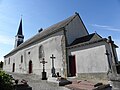
Saint-Sulpice church

Monastery chapel
_%C3%89glise_01.jpg)

literature
- Le Patrimoine des Communes d'Ille-et-Vilaine. Flohic Editions, Volume 1, Paris 2000, ISBN 2-84234-072-8 , pp. 811-818.
Web links
Commons : Saint-Sulpice-la-Forêt - collection of images, videos and audio files